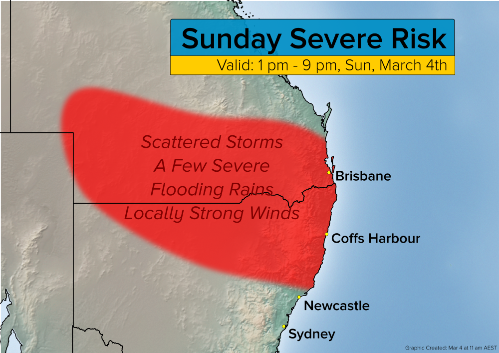
Much Anticipated Cherry Blossom Bloom Just Weeks Away Across Japan

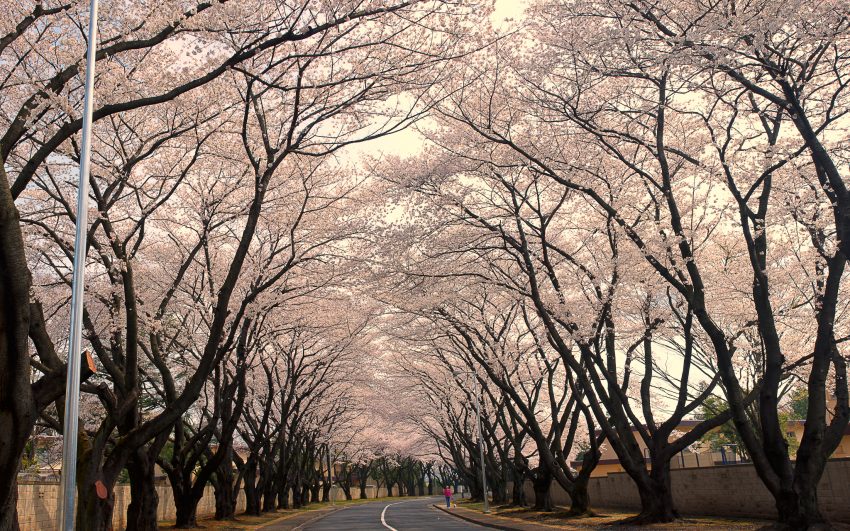
Residents and tourists alike are looking forward to the imminent blooming of Japan’s renowned cherry blossom trees. Although the lovely flowers have become common decoration across many countries, cherry blossoms (known as sakura) have special significance in Japan. The transient nature of the blossom is said to represent the beautiful but temporary nature of life, the inevitably of mortality. Cherry blossoms are used frequently across the spectrum of Japanese art from music to movies to decorative cookware. Starbucks stores in Japan even roll out cherry blossom-flavored beverages in the spring.

The Japan Meteorological Agency (JMA) helps monitor the progress of the “cherry blossom front”, the wave of blooms that open from south-to-north as temperatures warm each early spring. A sample set of fifty-nine trees across Japan is monitored for budding flowers. The southernmost home islands will see blossoms open first within the next few weeks. Experts project the blooms could happen as much as a week early thanks to unusually warm late winter temperatures. However, northern islands like Hokkaido may have to wait till early or even mid-May thanks to lingering wintery conditions there.

A Few Severe Storms Likely Sunday for Parts of NSW and QLD


Scattered storms will develop later this afternoon over portions of southern Queensland and northeastern New South Wales. A widespread severe storm outbreak is not expected due to weak upper level winds and questionable instability. However some stronger cells will likely produce heavy, flooding rainfall and gusty winds.

The time frame for severe storm development across the region is between 1-9 pm AEST. Brisbane could be threatened by 3 pm. At this time, the severe threat is expected to remain north and northwest of Sydney and Newcastle.


GOES-17 Satellite Launch Puts Latest Weather Tech Into Orbit

The latest in the GOES series of weather satellites, GOES-S, was launched from Cape Canaveral, Florida on Thursday. It joins GOES-16 in geostationary orbit, launched in late 2016. GOES-S will be redesignated GOES-17 when it becomes operational later this year. It will serve as NOAA’s GOES West satellite, responsible for covering the U.S. west coast, Hawaii, Alaska, and much of the Pacific Ocean.

The new GOES satellites will be able to collect three times the amount of meteorological data as their predecessors. They’ll also collect the data at four times the spatial resolution, five times as fast! GOES 17 in particular will have critical responsibilities that include monitoring winter storm systems approaching the U.S. and Pacific basin hurricanes. Thermal infrared imagery will help meteorologists spot fires faster (see above – image courtesy CIRA).

One of the most exciting new technologies on board the new GOES satellites is the Geostationary Lightning Mapper (GLM). Unlike ground sensor-based lightning detection networks, the GLM will be able to monitor lightning strikes over the ocean. These data could help radically improve forecasts of hurricane strength, for instance. However, it will not be able to distinguish between cloud-to-ground and cloud-to-cloud lightning strikes on its own.

Slow-Moving Storm Producing Torrential Rains across Northern Queensland!

An upper low drifting slowly across northern Queensland has a history of producing major flooding. As of Saturday morning, it’s still producing heavy rains over western parts of the state. These are less densely populated but more arid areas sensitive to these record rains. Here’s a select list of rainfall totals over the last several days:


Queensland Rainfall Totals (since 28-February):

Bluewater: 516 mm

Mt. Margaret: 509 mm

Stony Creek: 441 mm

Deeragun: 420 mm

Pallarenda: 342 mm

Townsville: 263 mm


A tap of rich tropical moisture from the Gulf of Carpentaria is to blame for the prolonged heavy rain threat. The upper low is expected to drift slowly and erratically over western Queensland and perhaps eastern Northern Territory, dropping additional heavy rains over the inland deserts through the next several days (see above). It could also help fuel a severe storm threat further southeast later this weekend. Check morecast.com and the Morecast app for the latest forecast details for your location!