Dangerous Cold Snap Pushing Into New England

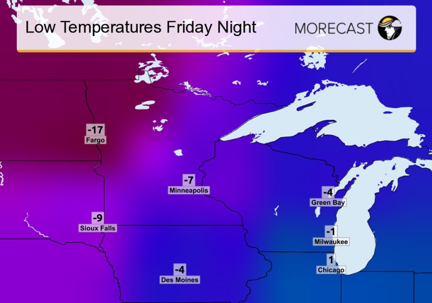
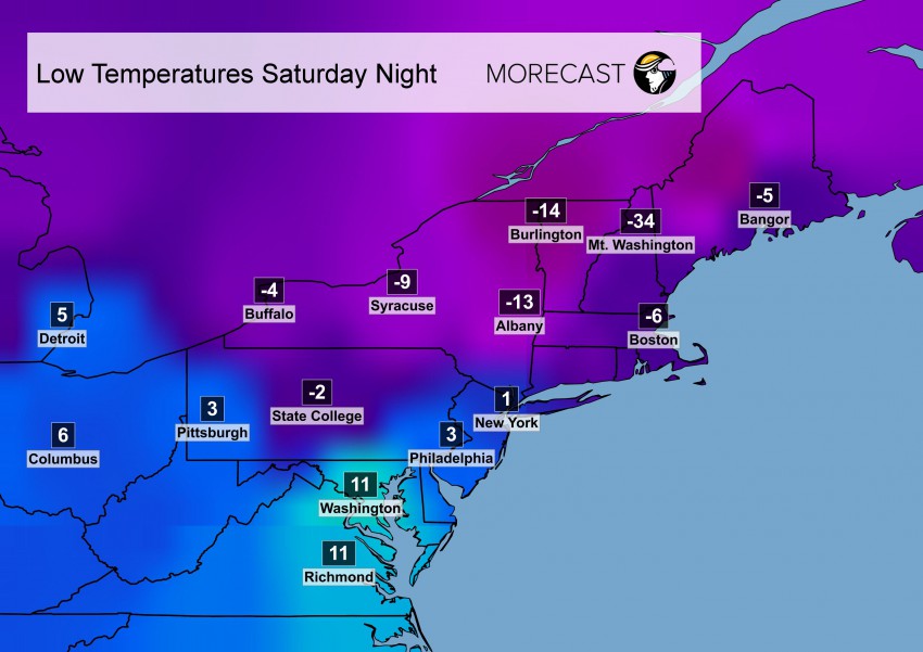
A strong push of dangerously cold arctic air will move into New England starting late Friday, with the coldest air arriving for the day Saturday and Saturday night. The most brutal conditions will occur Saturday evening, with temperatures expected to be subzero in most locations. New York City, which has not dropped below zero since January 1994, will be very close to zero, while Boston, Hartford and Buffalo are expected to see the mercury plummet below zero degrees. Adding to the danger will be gusty winds Saturday, which will knock the wind chills down to as much as 50 degrees below zero in interior New England and the higher elevations. Most major cities can expect wind chills between zero and -30 degrees. At those levels, frostbite of exposed skin can occur in as little as ten minutes, so limit your time outdoors this Valentines Day Weekend.

Read full article

Record Breaking Cold Snap Freezes the Northeast U.S. Sunday Morning

The well advertised arctic intrusion into the Northeast U.S. broke many temperature records Sunday morning, including in Watertown, New York which dropped to a frigid -37°F shattering the old record of -30°F set in 1979. In total, seventeen states east of the Mississippi River from Minnesota to Virginia to Maine had at least one observation with a temperature below zero early Sunday.  Every state in the Northeast had temperatures drop below zero Sunday morning with many locations falling to -10°F or lower.

Low Temps Sunday
Low temperatures across the Northeast from Sunday morning, February 14th. Source for the temperature data is the National Weather Service Mesonet

Read full article

Blizzard conditions and snow coming to the Northeast

There is a rapidly intensifying low that is pushing into the Northeast Monday into Tuesday which is causing a threat for snowfall totals to reach 12 inches. The main focal point is the Cape Cod area which will have blizzard like conditions and snowfall totals ranging from 6-12 inches.
Read full article