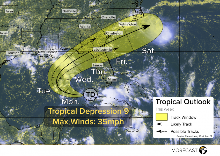
The ninth tropical depression of the year has been inundating Cuba over the last couple days. It’s showing signs of strengthening and is about to make a big right turn.
Tropical Depression 9 is now passing through the Florida Straits, producing torrential rain and flooding over parts of Cuba and the Florida Keys. Convection has organized somewhat overnight, but rotation still appears very broad and not very intense.
Tropical Depression 8 that’s approaching the Carolinas from the Atlantic is working to carve a path parallel to the East Coast that this storm will likely follow. This storm will continue tracking west today, but will likely begin turning tomorrow toward the northeast. Anyone with interests along the Florida Gulf Coast should watch this turn with caution, as it will dictate what parts of the Sunshine State will see the most impacts. Know your evacuation routes and have an emergency preparation plan ready to implement!
TD 9 has quite a bit of wind shear to contend with, causing the main thunderstorm activity to be southeast of the circulation center. This will work to impede storm development even as it tracks over very warm waters in the Gulf. This shear means that rapid development to hurricane strength is unlikely before it moves onshore. However, this storm likely will strenghten to a tropical storm during its time in the Gulf and preparations should start now before the effects start to be felt by Midweek.
Additional updates will be sent out via Facebook and Twitter. Use the MORECAST app to see forecast details specific to your location!