Tropical Cyclone Hola Churns in South Pacific

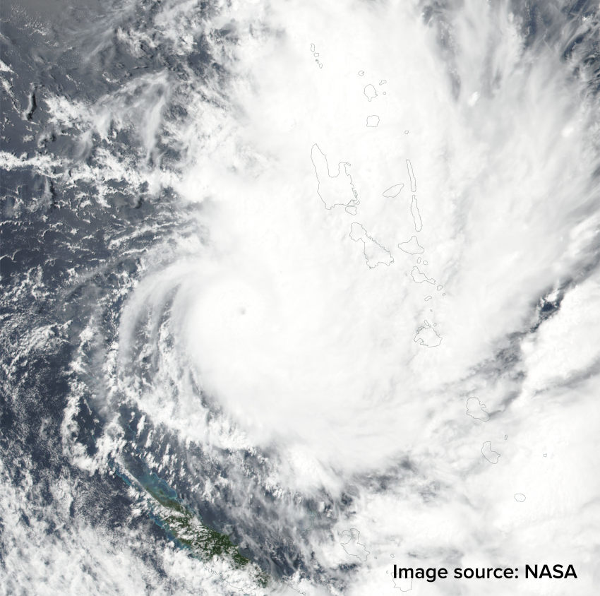
Tropical Cyclone Hola continues to spin in the South Pacific near the island of Vanuatu, about 1,600 km northeast of Brisbane, Queensland.

The slow movement of Hola this week has brought copious amounts of rain to Vanuatu. Since 7-March, the villages of Lamap Malekula and Saratmata have received close to 400 mm of rain.

Where will Hola go next?

Hola will begin to interact with a trough and move toward the southeast on Friday. Over the weekend, the tropical cyclone will merge with the trough and get steered toward New Zealand.

Sea-surface temperatures are currently warmer than average surrounding New Zealand. Orange and reds in graphic below indicate above average temperatures, while blues indicate below average temperatures (Map courtesy of tropicaltidbits.com). As Hola moves southeast into this area, these warm waters will help add fuel to the system.

Sea-surface temperatures are warmer than average across the waters surrounding New Zealand

Hola’s interaction with the trough will gradually transition the tropical cyclone towards a strong non-tropical cyclone. Despite the change in character, Hola will threaten the North Island of New Zealand with wind and rain as early as Sunday night or Monday. Auckland, New Zealands largest city, will be at risk for wind and rain on Monday.

Heavy Thundery Rain Potential For Central Australia

A slow moving disturbance will cross the Northern Territory bringing a heavy thundery rain threat to some normally drier regions in Central Australia.


What cities will be affected?

Cities such as Alice Springs, Tennant Creek, and Camooweal are expected to see rounds of thundery rain starting on Thursday and continuing into Saturday. 3-day rain totals in this area will average 50-100 mm, with some pockets of 100-200 mm of rain likely.

The expected rain falls will lead to a risk for flooding.

Who else will get rain?

Farther to the east, additional rounds of thundery rain across central Queensland will add to the already impressive rain totals so far this March. Communities such as Mount Isa, Cloncurry, and Trepell have seen 100-300 mm of rain since March 1st.

The thundery rain across most of western Queensland will come to an end by Saturday as drier air pushes in from the east. This drier air will bring an end to the thundery rain threat in places like Alice Springs by Sunday.

A third area of heavier thundery rain will exist across the east coast of far northern Queensland from near Townsville to Cairns. The culprit for the rain here is a persistent onshore flow aided by a weak low pressure system over the Coral Sea. The greatest potential for heavy rain will be through Friday, before thundery showers become more sparse over the weekend.


Nor’easter Pummels Northeast with Snow, Rain, Wind

A quickly strengthening nor’easter will move up the Northeast coast bringing heavy snow, wind, and rain Wednesday and Thursday.

The Details:

The heavily populated I-95 corridor from Philadelphia to New York and close to Boston will see accumulating snow, though amounts will vary greatly. The potential exists for 6-12 inches of snow, especially if a heavier snow band sets up. Travel will be difficult to nearly impossible at times within the areas of heaviest snow. Air travel will also be impacted, with numerous cancelled flights already in the Northeast Wednesday afternoon.

Strong winds will batter coastal locations and bring the second risk for moderate coastal flooding in less than a week. Where the stronger winds are combined with snow, visibility will be reduced to near zero at times.

The combination of heavy wet snow and strong winds will lead to downed trees and scattered power outages.

The storm will lift into central and northern New England on Thursday with significant snow and strong winds expected.

In the wake of the nor’easter, seasonably chilly air with scattered snow showers will continue on Friday as broad northwest flow keeps the colder and unsettled weather pattern in place.


Mid-Week Nor’easter Targets Northeast With Snow, Wind

On the heels of one of the worst winter storms in years, a second storm will target the Northeast with heavy snow, wind, and rain beginning Wednesday.

Colder air will be drawn closer to the coast with this storm, which will bring the likelihood for an impactful snow accumulation to parts of the coastal plain.

Parts of the I-95 corridor from Philadelphia to New York and Boston are likely to receive 3-6 inches of snow, with more than a foot likely in the northwest suburbs. The Jersey Shore and far southeast New England look to stay milder enough for mainly rain.

Model Simulation Of Nor’easter:


The Details:

A band of rain and snow is expected to push across the northern Mid-Atlantic through Wednesday morning. By midday Wednesday, low pressure will develop off the Mid-Atlantic coast and begin to enhance the precipitation across New Jersey, Pennsylvania and southern New York. Precipitation rates will increase as the low pressure strengthens and moves northeastward. The heavy precipitation will move into New England Wednesday afternoon and night. Where it is cold enough, snowfall rates of 1-3 inches per hour are likely, which will make travel difficult to near impossible at times.

Strong winds will also be factor, however, maximum wind gusts are not expected to be quite as strong as the previous storm last Friday. Still, the combination of strong winds and heavy wet snow will bring the risk of downing weaker tree branches and scattered power outages.

Coastal flooding will be a concern again for many east and northeast facing shorelines.