Beijing Sees Wettest Day In Six Months; Rain Targets Korean Peninsula Next

Low pressure moving across eastern China has brought Beijing its wettest day in more than six months. The heavy rain will target the Korean Peninsula through Monday.

The Details:

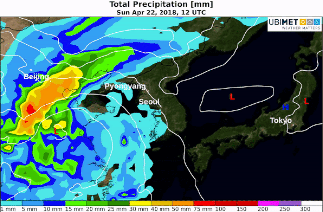
Beijing picked up 27.2 mm of rain on Saturday, which is the most rain in the city since October 10th, 2017 when 52 mm of rain fell. The rain has now ended across most of the metro area.

Steady to heavy rain will spread across the Yellow Sea on Sunday and move into the Korean Peninsula on Monday.

The swath of heaviest rain is expected to setup from just south of Beijing eastward across the Yellow Sea and through South Korea. 50-100 mm of rain is expected in this corridor over a 24-36 hour period of time.

Rainfall setup this weekend into early next week

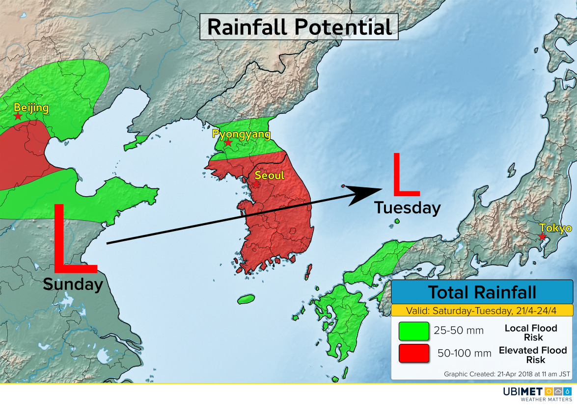
Monday is expected to be a rainy day across South Korea as low pressure moves across the country. Some flooding is possible in the areas of heaviest rain, including around Seoul.

As low pressure moves into the Sea of Japan on Tuesday, it will weaken and consolidate with a stronger low farther south.

Below is a model animation showing expected rainfall totals from Saturday afternoon through Tuesday.

No Relief for Drought-Ravaged Areas of the High Plains


Wildfires raged out of control on Tuesday across parts of the Plains, especially Oklahoma, Kansas, and Colorado. The system responsible for high winds and hot temperatures has moved off to the east. However, soil conditions will remain dangerously low thanks to more than six months of little to no precipitation. This is particularly true from southwest Kansas through the Panhandles to northeastern New Mexico. Other than 0.24″ of rain recorded on March 27th, Amarillo has seen no measurable precipitation since early October.


This kind of extended drought creates an abundance of dry tinder, plant and other debris that ignites easily. Any increase in winds and/or temperature means an extreme wildfire threat. Minor brush fires quickly grow beyond the ability to be controlled. The graphics at bottom reflect the forecast for the next few weeks with a decent chance of some passing rain. Still, minor moderation of the drought won’t diminish the wildfire threat significantly. Indeed, lightning-bearing storms have been known to spark wildfires in sensitive conditions.


Choking Dust in the Air Across the U.S. Plains Thanks to High Winds and Drought


High winds are whipping up dust and smoke across the High Plains today. You can distinguish the brown-colored dust in the satellite loop below especially from eastern Colorado into western Kansas. You can also see the grayish wildfire plumes in northwestern Oklahoma, the Texas panhandle, and near the Kansas-Colorado border.


Temperatures have soared to near 100 degrees this afternoon in portions of northwest Texas and western Oklahoma. Adding to the blowtorch effect are winds gusting commonly in the 60-70 mph range (see graphic below). A gust to 100 mph was recorded at Burlington, CO earlier! This combination of hot and dry air with high winds has made for a lethal wildfire threat. In addition, wind-blown dust can drive visibilities down to near zero, creating hazardous driving conditions.


The ground will remain dangerously dry in this region thanks to months of below normal or no precipitation. However, the system responsible for the high winds and heat will move east. The fire danger should diminish somewhat for Wednesday.

Wildfire Danger in the High Plains Early This Week!


After a brief cool-down, gusty southwest winds are pushing temperatures quickly back up over the Southern Plains. Temperatures which started Sunday morning in the 20s over the Texas Panhandle have jumped back up to near 90 degrees on Monday afternoon. Meanwhile, southwest winds are gusting up to 40 mph, combining with months-old drought to produce a dangerous wildfire threat.

As you can see in the satellite animation below, wildfires are breaking out in many areas. These are distinguished by their plume-like appearance, contrasted with the fast-moving, elevated clouds to the west. Many of the plumes in the upper right of the picture (southeast Kansas and northwest Oklahoma) are probably controlled burns. However, the two plumes that appear late in the loop over western Oklahoma are certainly wildfires.


The situation looks even worse for Tuesday. The map below shows forecast humidity values for Tuesday afternoon, at or below 10% from western Oklahoma into the Texas Panhandle and further west. Winds will increase with gusts of 50-60 mph, and temperatures will again approach or exceed 90 degrees. The result: a historically large wildfire risk (see graphic at bottom from the Storm Prediction Center who handles fire forecasting). Any fire sparked in this region will be very likely to run out of control, threatening homes and businesses. An elevated fire risk will still exist on Wednesday and beyond, however the region affected should shrink back to desert areas of New Mexico and west Texas.