Beta Drenches Houston While Massive Teddy Rolls Toward Maritime Canada


An extremely active tropical cyclone period seems to be winding down. As of tonight (Tuesday, 22-Sept) there are no more active tropical cyclones in the Atlantic Basin, and none expected in the next several days. However, two post-tropical storms will continue to cause major issues through Wednesday.


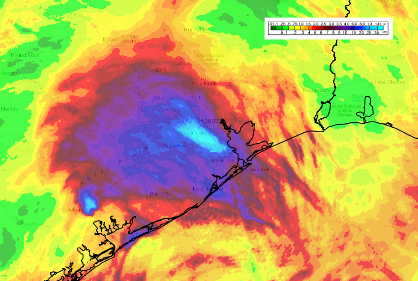
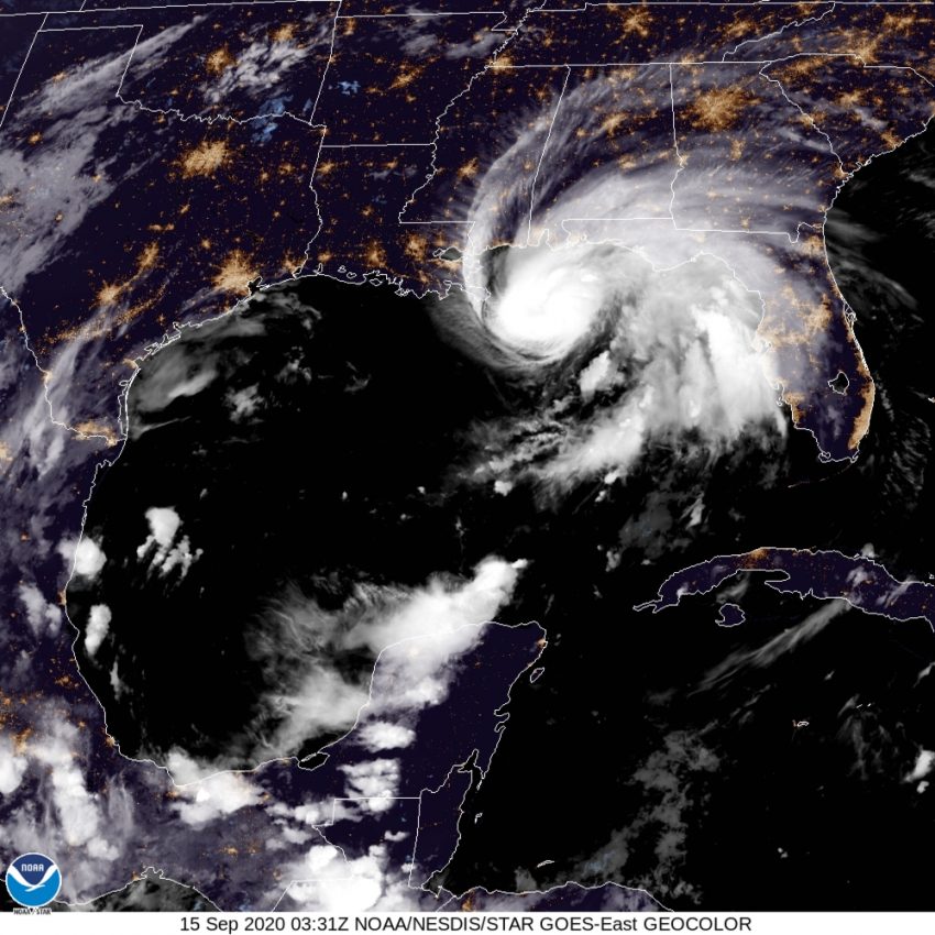
Post-tropical storm Beta has been drifting slowly near or along the western Gulf Coast for the past several days. When it made landfall on Monday night, it was the ninth named storm of the season to do so, tying a record for the most active season with plenty of time to break it. Although damage due to wind or storm surge has generally been slight, Beta has dumped torrential rain across much of southeast Texas. Parts of the Houston metro have seen 7-14 inches (175-350 mm) of rain since the weekend (see map above). Serious flash flooding has been result, closing down major highways and interstates and requiring numerous water rescues of stranded vehicles. This excess rainfall has already and will continue to cause dangerous rises in area creeks and rivers. Fortunately, Beta is beginning to weaken and move more quickly, reducing the flash flood threat going forward.


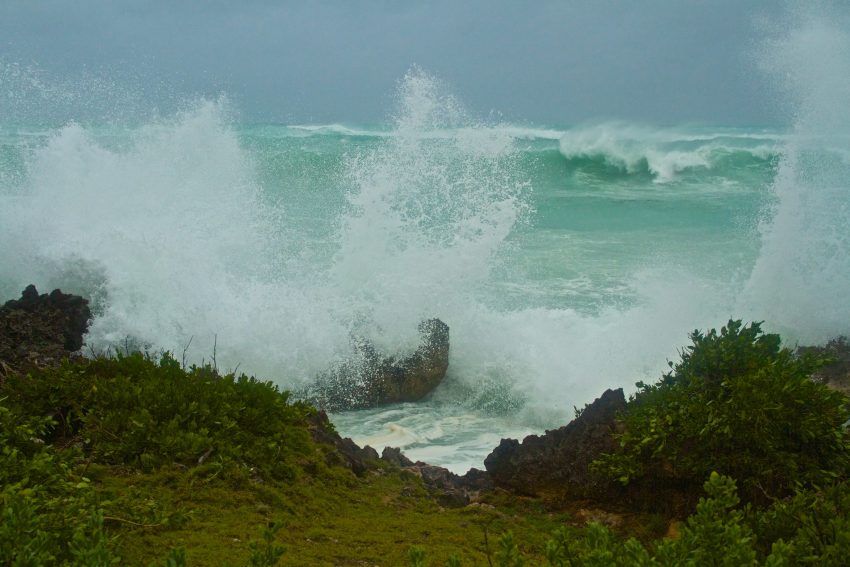
Hurricane Teddy peaked at Category Four intensity last week while moving over the open Atlantic. Fortunately, Teddy has thus far managed to avoid any serious direct impacts to land, although it brushed the island of Bermuda with gusty winds and rain. Teddy has, however, pushed high waves and elevated tides far ahead of its circulation. The entire eastern seaboard of the U.S. has seen this kind of rough surf over the past few days (see tweet video below from Maine). Teddy has transitioned to a post-tropical storm, but an extremely large and powerful one. Hurricane-like conditions are affecting portions of coastal Nova Scotia with Newfoundland likely the next target on Wednesday. Lead photo courtesy flickr users Lee and Chantelle McArthur.


Sally Intensifies Rapidly, Landfall Late Tonight or Early Wednesday in Mississippi


Sally started the day as a tropical storm but has undergone rapid intensification due to very warm waters and favorable upper level winds. Now a dangerous Category Two, Sally could intensify further before landfall late Tuesday or early Wednesday. Deadly storm surge, destructive winds, and torrential rainfall will hammer the Gulf Coast from Louisiana to the Florida panhandle.


For the first time since 1971, five named cyclones occupied the tropical Atlantic basin simultaneously Monday (see map above). Rene has weakened to a remnant low. Tropical Storms Teddy and Vicky pose no immediate threat to land. Paulette passed directly over the island nation of Bermuda on Sunday night into Monday morning as a Category One hurricane. It’s only the tenth time in recorded history that a mature hurricane’s eye passed directly over the island. Some residents reported damage to their homes, but for the most part it seems the island escaped significant impacts.


Unfortunately, Hurricane Sally won’t be so passive. Significant surge flooding is already being reported along the Alabama coast with torrential rainfall over parts of the Florida Panhandle. Sally is moving slowly west-northwest and may slow down even more into Tuesday. The very warm waters over the northeastern Gulf will continue to provide fuel for intensification. Sally may even approach major hurricane status as it approaches the coast. Regardless, locations along the coast from southeast Louisiana to the Florida-Alabama border will be inundated by a deadly storm surge up to nine feet (2.75 m). Destructive winds gusting to 120 mph (190 kph) will bring down numerous trees and powerlines and tear roofs from homes. The slow storm motion will also translate into prodigious rainfall totals up to 18 inches (450 mm) in spots, leading to major freshwater flooding. Conditions will continue to deteriorate through Tuesday in the target zone with landfall expected on Wednesday morning.

Typhoon Haishen Rips Through Japan and South Korea


The busy port of Busan, South Korea suffered a direct hit from Typhoon Haishen on Monday morning, just hours after it raked the Japanese island of Kyushu. Fortunately, Haishen had weakened significantly since peaking at Category Five status late last week. Still, the region saw damaging winds and serious flooding as the storm moved through.


Haishen continues to move rapidly north today, weakening as it does. The storm will be not much more than a remnant low tonight into Tuesday as it moves through North Korea and into eastern China. However, Haishen was a much stronger storm overnight Sunday into early Monday as it passed close to Kyushu Island and slammed into southeast South Korea. Winds gusting in excess of 130 mph (210 kph) were reported in the southern Japanese Islands, along with widespread rainfall around eight inches (200 mm). Rain-prone mountainous areas saw much higher rainfall as much as 23 inches (580 mm)! The typhoon threat provoked nearly a million Japanese residents to evacuate from their homes. Hundreds of thousands were without power due to the storm as of Monday morning.


Haishen is the third typhoon in the past few weeks to strike the Korean peninsula after Bavi and Maysak. It’s the first time in nearly 75 years that three typhoons have struck the Koreas in the same season. Haishen is also the fifth named storm to strike the peninsula this season, a new record. Lead photo courtesy wikipedia contributor Stephen Wheeler.

Busy Western Pacific Pattern with Multiple Typhoons Battering Korean Peninsula


An especially active period of typhoon activity continues over the Western Pacific. South and North Korea will continue to be the main focal point for the worst impacts. These storms are coming on the heels of devastating monsoonal flooding earlier in August that claimed dozens of lives. Typhoon Bavi struck North Korea last week, followed by Maysak just today in South Korea. The third and strongest typhoon, Haishen, looks to strike nearly the same region by this weekend.


Bavi reach Category Three status as it moved through the Yellow Sea last week. Fortunately it weakened just before landfall over north Pyongan Province on Thursday, 27-Aug. Minor damage was reported in China, South Korea and some of the southern Japanese islands. More serious impacts, including flash flooding as well as downed trees and powerlines, occurred near landfall in North Korea. Maysak peaked at Category Four intensity on Tuesday over the East China Sea. It was around this time that a livestock-carrying ship, the Gulf Livestock 1, was struck and feared lost with 43 crew and nearly 6,000 head of cattle. Like Bavi, Maysak weakened considerably before landfall but still caused wind damage and power outages for 200,000 households in south and east South Korea.


Typhoon Haishen is currently a Category One with maximum sustained winds to 85 knots (155 kph). However, rapid intensification is expected the next few days as the typhoon moves slowly west-northwest over very warm waters. Haishen will then accelerate and turn north-northwest towards the southern Japanese Islands (see forecast map above). Another South Korean landfall is expected this weekend, very close to the major port city of Busan. Like the other recent storms, some weakening is expected before landfall. However, the cumulative effect of monsoonal flooding and the recent typhoons has left the region vulnerable. Downed trees and powerlines will occur more readily over a densely populated area, leading to major disruptions.