Tropical Rains Bring Deadly Flooding to Japan

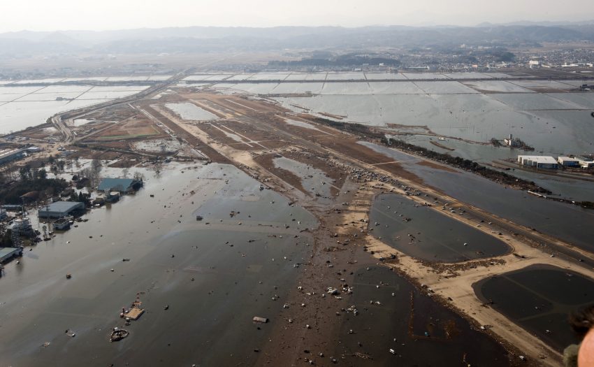
Extreme rainfall has inundated parts of southwest Japan over the last few days leading to deadly flooding.

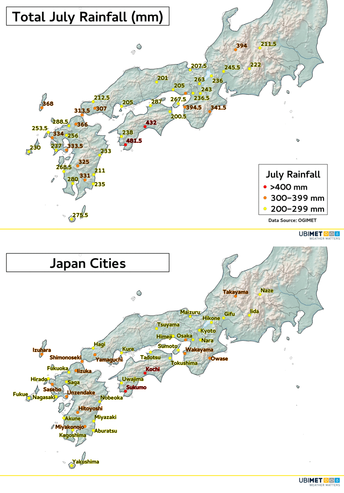
The city of Sukumo in Japan’s Shikoku Prefecture has received 390 mm of rain in a 24 hour period over the weekend. 334 mm of that fell in just 6 hours.

That easily places Sukumo at over 400 mm of rain for the month of July.

Other Japan Prefectures such as Kyushu, Chugoku, Kansai, and Chubu have also been affected by heavy rain and destructive flooding.

According to CNN, over 40 people have already been killed, and that tally could continue to rise over the coming days.

One of the main factors that contributed to the heavy rain was a stalled frontal boundary over the area. Copious amounts of tropical moisture rode along the frontal boundary dropping the extreme rainfall in a short period of time.

Additional showers will continue on Sunday, however, the heaviest rainfall has ended for most areas.

The region will get a much needed break from widespread precipitation for much of the upcoming week.

Record-shattering Heat Engulfed Southern California Friday

The hot weather that has gripped much of the US during the first week of July centered itself over heavily populated southern California on Friday.

Record-shattering Heat

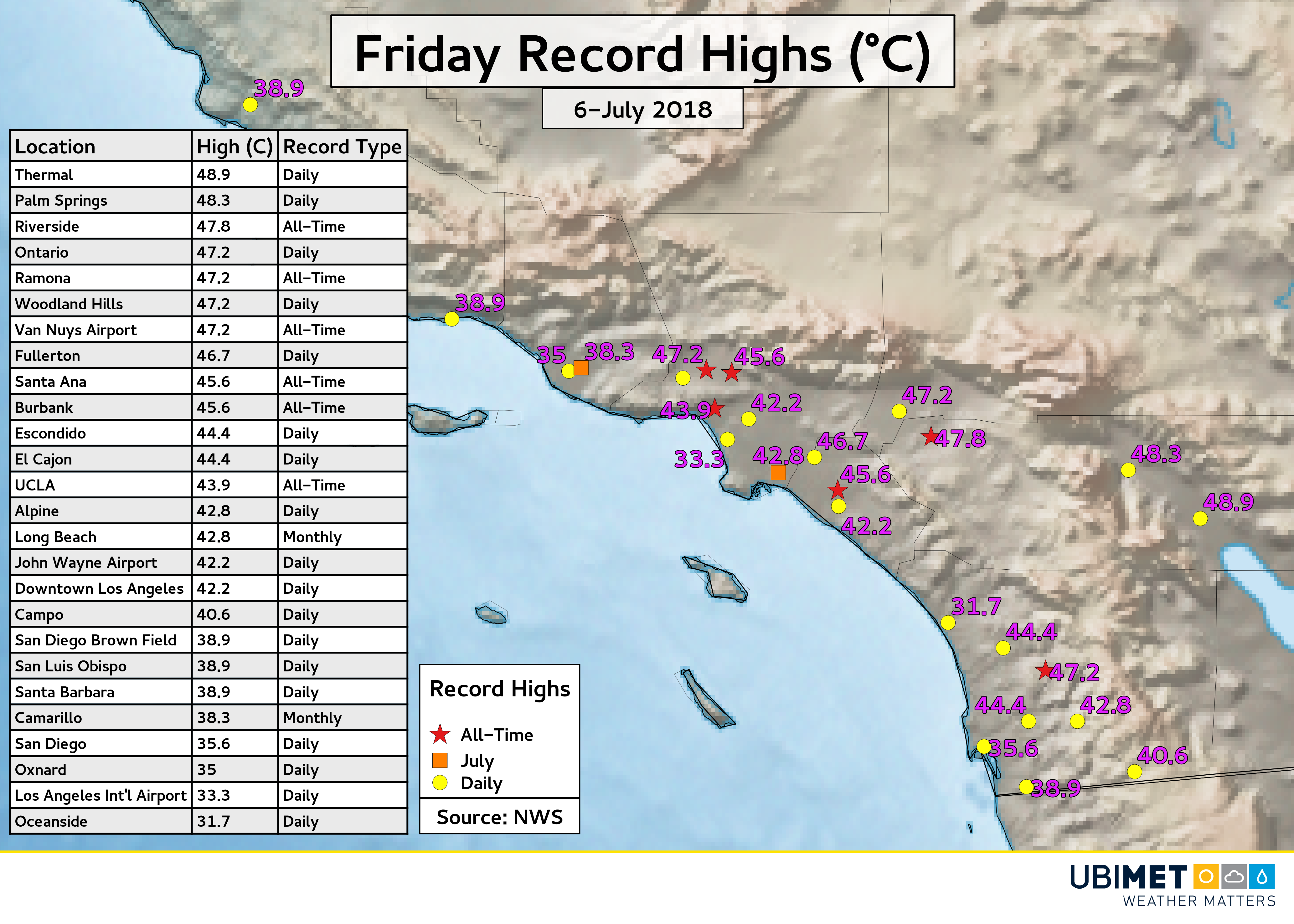
26 daily record highs were set, and many of the records ended up being shattered by more than 6-11 degrees°C (10-20°F). All of the climate stations in the Los Angeles and San Diego areas were among the 26 record highs.

In additional to daily records, at least two stations set July record highs and six stations set all-time record highs. In Santa Ana, the previous all-time record high of 44.4°C dated back to 1917. On Friday, the city broke that 101-year record by reaching a sweltering 45.6°C.

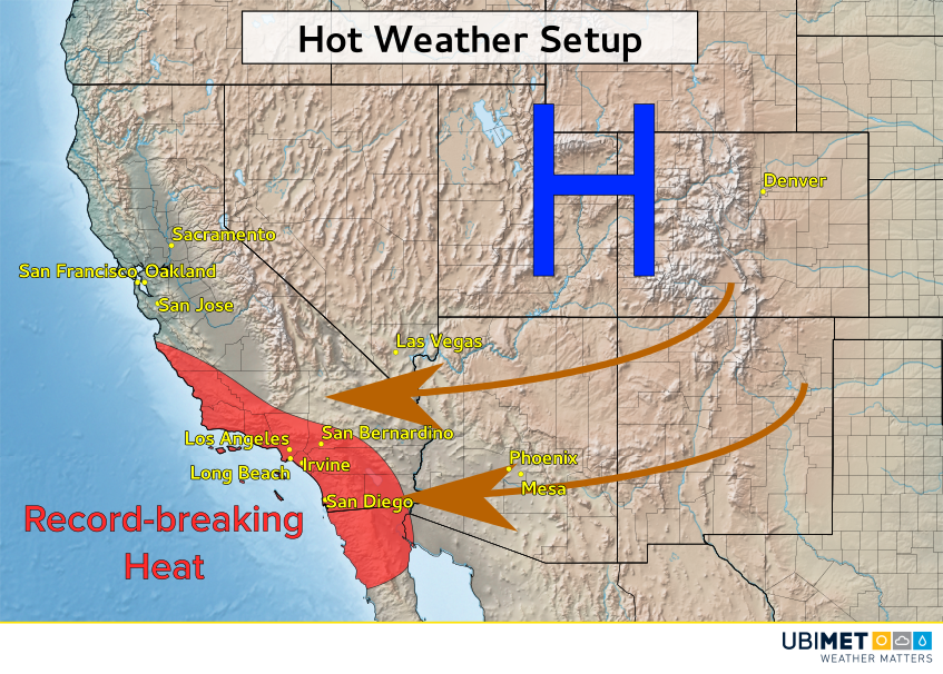
The reason for the extreme heat over southern California can be traced to a hot dome of high pressure that was centered across the Southwest US.

The flow around the high pressure system pushed hot and dry air from the desert all the way to the coast, blocking the typical onshore flow from the cooler Pacific Ocean.

Additional record highs have been set this weekend, however, the most extreme heat has past.

Temperatures will edge down closer to average during the first few days of the upcoming week.

More Snow to Whiten Australian Ski Resorts This Weekend

A cold disturbance crossing southeast Australia on Saturday will add more snow this weekend to the already snowy Alpine region.

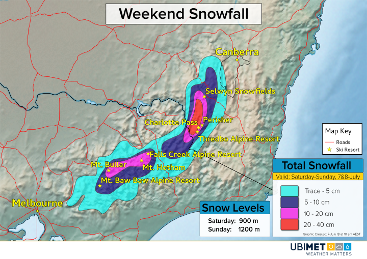
Weekend Snow Forecast

Skiers and other winter enthusiast woke up to heavy snow and near whiteout conditions across the Alpine region above 1300 meters.

The heaviest snow fell from Friday night into Saturday afternoon, however, snow showers will continue at varying intensities into Sunday.

The highest snow totals this weekend will fall across the higher terrain of the NSW Alps. Snowfall of 20-40 cm above 1500 meters is expected, including across most of the ski resorts. Many of the ski resorts in VIC will likely approach 20 cm of new snow.

Snow levels on Saturday will be as low as 900 meters at times, however, most of the accumulating snow will be around and above 1000 meters.

Temperatures will be around a degree or two milder on Sunday sending snow levels up closer to 1200 meters.

UPDATE: Typhoon Maria Rapidly Strengthening, Now Targeting China!


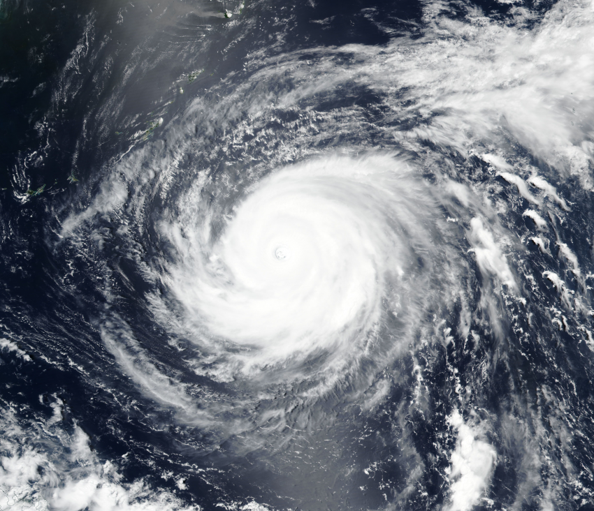
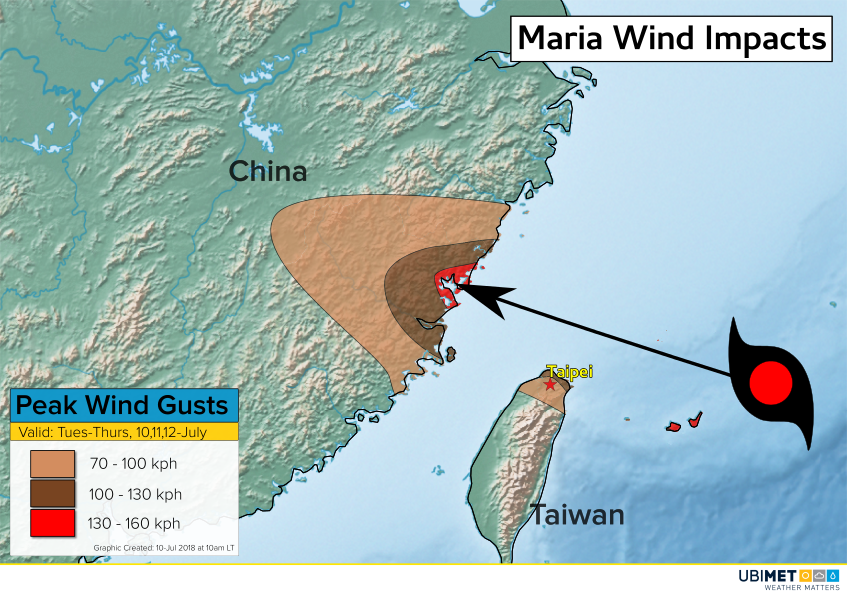
Typhoon Maria has rapidly intensified overnight (lower right of satellite animation below) and is now producing wind gusts up to 250 kph (155 mph). Further strengthening is expected as Maria moves northwest over very warm sea surface temperatures with little wind shear. Locations from Taiwan to mainland China to Korea and southern Japan remain in danger from a dangerous cyclone strike next week!


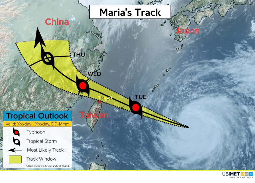
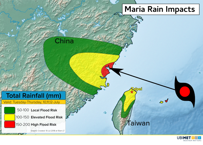
The latest model guidance indicates a shift towards the west with Maria’s future track. The most likely track carries Maria towards the Shanghai region around the middle of next week. Although Maria would likely weaken as it approaches the mainland, that still represents a major threat to tens of millions of residents in the world’s third-most populous city. However, there’s plenty of time for steering currents to change. Eastern China, Taiwan, Korea, and Japan remain potential destinations.


Maria is likely to become a Super Typhoon in the next few days. Devastating impacts are likely for the Ryukyu Islands between Taiwan and Japan early next week. After that, Maria will move over cooler sea waters with increasing shear, leading to steady weakening.

Meanwhile, torrential rainfall continues in central and southern Japan, forcing widespread evacuations. One location in Kochi prefecture has seen 850 mm of rain over the past two days! Additional heavy rains, locally up to 200 mm, will fall in the next 48 hours. Flash and river flooding will be an increasingly widespread and serious hazard. Landslide warnings are also in effect across the region.