Record-Setting Heat Wave Scorches Most of Australia
Australia summers are routinely hot over the deserts of the central and southwest. However, this week has seen numerous high temperature records set. Tuesday was the hottest day on record in Australia in terms of nationwide average temperature. The record was short-lived, however, as Wednesday’s number outpaced Tuesday’s by a full degree!
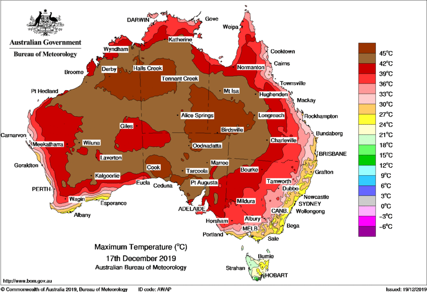
The map above shows high temperatures recorded in the past three days (17-19 Dec). You can see the vast stretches of the center and west that saw highs peak above 45 deg C (113 deg F). The average high for the country on Tuesday reach 40.9 deg C (106 deg F), a new record that lasted only about 24 hours. Wednesday’s average soared to 41.9 deg C (107 deg F). Nullarbor, SA reached 49.9 deg C Thursday, setting a new national high temperature mark for the month of December. It’s an unsettling way to start the summer that’s only three weeks old. The extreme heat is shifting east towards portions of Victoria, Queensland and New South Wales. Highs are easily exceeding 40 deg C at Adelaide, quite unusual that far south. Sydney and Melbourne will get in on the act with temperatures reaching the mid-40s for locations inland from the immediate coast on Friday and Saturday.
A day after Australia’s hottest day on record, the country’s most populous state declared its second emergency in as many months as extreme heat and strong winds stoked more than 100 bushfires. More here: https://t.co/QWdICDsyjM pic.twitter.com/9fQDOPnDCz
— Reuters (@Reuters) December 19, 2019
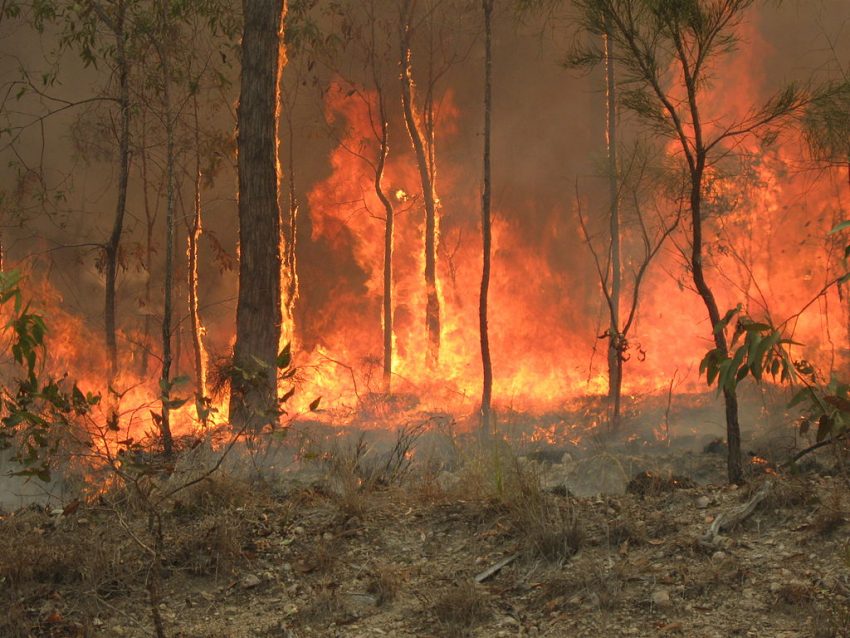
This blistering heat is exacerbating the dangerous wildfire threat in some parts of the country, especially in the east. Air quality is also extremely poor due to thick, choking smoke downwind of the blazing wildfires. Conditions are so primed that officials have instituted a total burn ban across several states, including New South Wales. In fact, a state of emergency has been declared, the second time in as many months that it’s been necessary. The state of emergency gives additional powers to firefighters to issue evacuations, close roads, and even shut down water and electricity services. Wildfires have been raging over portions of New South Wales and Queensland for weeks, burning more than seven millions acres and destroying almost 700 homes and businesses. Lead photo courtesy Wikipedia contributor 80 trading 24.