From Fires To Floods; Sydney, Australia Receives Deluge Of Rain

Following months of dry and hot weather, the heavens opened up over over eastern New South Wales during the past few days. The city of Sydney was brought to it’s knees as a barrage of heavy rain and flooding inundated the city, and surrounding metropolitan area from late last week through the weekend. Staggering rainfall amounts ranging from 150-400 mm(6-16 inches), which have not been seen since the 1990s,smashed records throughout the region. The rains were accompanied by strong winds and coastal flooding, as an east coast low left much of the area reeling. This has prompted the Insurance Council of Australia to declare a catastrophe in eastern New South Wales. Current claims are at $45 million, and are likely to climb in the near future.

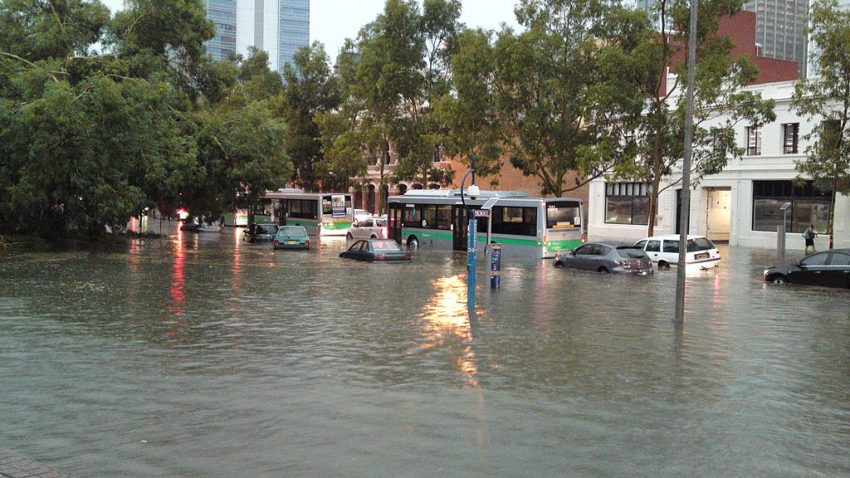
An evacuation order remains in place for many neighborhoods in and around Sydney as rivers, creeks, and even lagoons have come over their banks. Street flooding due to drainage systems not being able to keep up with the excessive rainfall has been very prevalent as well. 200 water rescues have been performed since the weekend in Sydney alone, mostly due to motorists driving into flood waters. One dramatic rescue involved a 16 year old boy who was fishing along the Allynbrook River.

Wind gusts of over 100 kph(62 mph) rocked the region. This led to thousands of trees being toppled, which then led to widespread power outages. At the peak, around 140,000 customers were without power, but close to 100,000 remain in the dark as power crews work feverishly to restore it. Massive train delays and school closures is what welcomed Sydneysiders this morning. Numerous landslides have been reported, with more expected in the coming days, as soils in areas previously burned by the recent bushfires have become transient after the heavy rain.

Coastal flooding due to the presence of King Tides combined with a stiff onshore wind, has left many coastal communities under water. Waves as high as 8 meters(26 feet) contributed to significant erosion along the beaches. The waves were strong enough to pull a buoy off of Collaroy Beach off of it’s moorings. These effects are very similar to what is expected during a tropical cyclone.

Despite the wave of destruction unleashed upon the region, there are a few positive outcomes from all the rain. One for which is a substantial drop in the number of active fires. Before the rains there were 62 active fires, and now there are just 38. One particular fire, known as the Currowan Fire, is finally extinguished after burning 500,000 hectares(1.2 million acres) over a 74 day period. Another beneficial result of the rain is that Sydney’s water supply is now nearly 75% full after being at 43% just last week. This will stave off the threat of water restrictions which had been looming in the wake of the recent drought.

Tropical Cyclone Damien Strikes Northern Western Australia

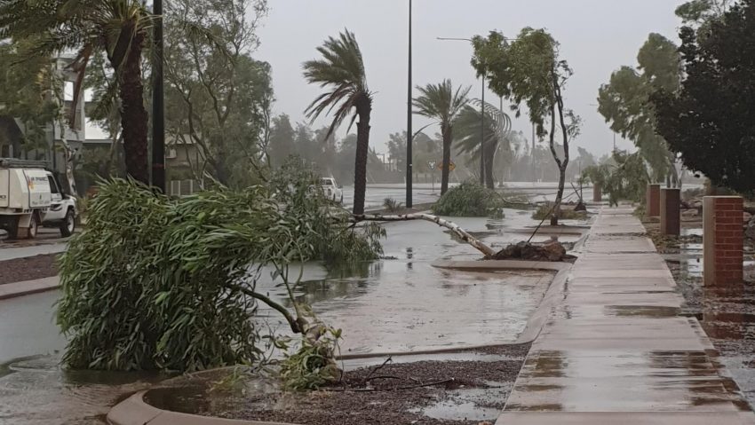
Considerable damage has been reported in the Pilbara region of Western Australia due to Tropical Cyclone Damien, which is the third cyclone to affect the area this year. The storm made landfall near Karratha on Saturday night as a category 3, with winds of 205 kph(127 mph). 10,000 people are currently without power as a red emergency alert remains in place for the area, and residents are being urged to stay inside their homes until the authorities give the Ok to come out again.

Damien brought destructive winds, storm surge, and torrential downpours to the region. Crews are still surveying the damage, but no deaths have been reported thus far. Rainfall totals have averaged 200-250 mm(8-10 inches), and many roads were flooded. A considerable amount of homes have sustained at least some damage, with destroyed roofs being the most common form of destruction.

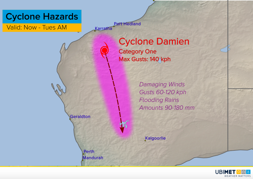
Despite Damien being downgraded to a category 1 storm with winds currently at 92 kph, the threat for more damage still looms as the storm moves further south into central Western Australia in the coming days. Flooding rains, with possible totals near 200 mm(8 inches), and strong wind gusts, up to 140 kph (87 mph)will be the main hazards going forward until the storm completely diminishes early next week.

Flooding Rains Spreading Down the New South Wales Coast!


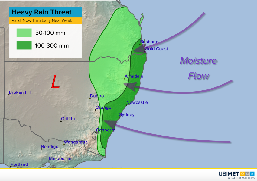
Heavy rains have been falling today along the coast of southeast Queensland and northeast New South Wales. Amounts exceeding 100 mm have been recorded in spots. This heavy rain is spreading south along the New South Wales. It’s part of a pattern shift away from the dry, hot, wildfire-friendly conditions of a few weeks ago towards one that is cool and rainy.


The map above shows the overall setup. An upper level low has parked itself over northern NSW and won’t be dislodged for several days. Meanwhile, persistent onshore flow at the surface will bring moisture from the ocean into eastern New South Wales. This flow will be perpendicular to the mountain ranges, and east-facing slopes will help enhance upward motion of the moist air. The combination of these factors will make a perfect recipe for prolonged, occasionally heavy rainfall along the east coast of New South Wales, including the Sydney metro area.

Widespread rainfall totals of 150-300 mm are expected through early next week with localized heavier bands dropping totals upwards of 400 mm. These amounts will lead to serious flash flooding. Some of the mountain slopes are likely to see landslides. Increasing easterly winds gusting as high as 60-80 kph will combine with rain-weakened soils to down trees and powerlines, resulting in power outages.

Bushfires Approach Australian Capital Of Canberra

Bushfires are currently burning just south of the Australian capital city of Canberra. 35,800 hectares(88,500 acres) where burned by Saturday afternoon in the Orroral Valley in nearby New South Wales. This has prompted a state of emergency to be declared in the capital district and surrounding areas, which is the first time this has occurred since 2003. Residents in the city of 400,000 are on edge as heat, combined with dry, and windy conditions are creating the perfect setup for fire to spread rapidly. Many fear a repeat of what happened in 2003, in which 500 homes were destroyed in one day throughout the district. So far, only 20 homes have been destroyed within the district.

A total fire ban has been enacted, while officials have urged residents to fill up their sinks, buckets, and bathtubs so that they have access to safe water to drink and to extinguish flames when fires arrive. Canberra set an all time record high for February on Saturday with 42.7 degrees(109 degrees Fahrenheit). The record heat has been accompanied by strong, drying winds, which is making it very difficult for firefighters to control the flames. Isolated thunderstorms in the area have proven to be more detrimental than beneficial, as they are producing more lighting than rain, leading to additional fires being ignited. The fires themselves have been generating their own weather patterns in some cases, in which lighting and strong winds are developing within them, leading to even more fires. The extremely fire conducive conditions will last until Monday. By then, cooler temperatures, higher humidity, and less wind should assist firefighters with getting a handle on the blazes.

This latest round of fires is coming on the heels of an already deadly and destructive bushfire season for Australia. Since September, 33 people have been killed nationwide, while 3000 homes have been destroyed. 10.5 million hectares(26 million acres) have burned, and scientists estimate that over one billion animals have perished.