Record Cold, Snow Blast New York City!

After a very mild and basically snowless winter, New York City, along with many other locations across the northeastern United States were dealt a blast of arctic air and even some snow on Saturday morning. The highly anomalous airmass, which originated over the Arctic Ocean, is responsible for numerous record lows in the region.

As the airmass rolled in late on Friday night, the temperature in New York’s famed Central Park dropped to 36 deg F (2.2 deg C ) which broke the record for May 8th of 37 deg F (2.7 C) set back in 1947. By early Saturday morning the temperature dropped to 34 deg F (1.1 deg C) which not only broke the record for May 9th of 35 deg F (1.6 deg C), also set in 1947, but is the coldest it has ever been on record this late in the season. Although not a record, Saturday’s afternoon high in the city only reached 47 deg F (8.3 deg C). This is not only 21 degrees below average, but more typical of high in early December, rather than early May.

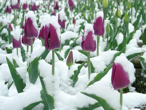
The unusual cold temperatures were accompanied by very rare May snow. A trace of snow was recorded in Central Park, which ties the record set on May 9th 1977 for latest snowfall in a season. The trace of snow is equal to what the city recorded in all of this past February. In nearby Islip, New York, a trace was also recorded, which is more than what actually occurred in February. Much higher amounts of snow were seen in various locales across the northeast. One such place was Sugar Hill, New Hampshire, which recieved 10.5 in (27 cm) of snow.

With the growing season well underway, widespread freeze warnings are in place throughout the region. Given that it is May, prolonged periods of cold cannot be sustained, and a warm up will commence by midweek.

Another Round of Severe Weather Strikes Southern U.S.!

Once again the American South is ground zero for severe weather, in what has been a seemingly endless streak of death and destruction over the last few weeks. The region was hit by a barrage of flooding rains, damaging winds, and deadly tornadoes from Wednesday into Thursday. At least 7 people have been killed, while widespread damage has been reported across several states. 44 tornadoes have been reported during the two day period.

In the town of Madill, Oklahoma an EF2 tornado, with winds between 111-135 mph (179-217 kph), touched down on Wednesday afternoon. The twister is responsible for two deaths. One of the victims was a worker at a local steel factory whose body was found 6 miles (10 km) to the southwest of Madill. The factory where the man worked has been heavily damaged, putting it’s 600 employees out of work.

Onalaska, Texas was another town struck by a deadly tornado. Here, it is estimated that an EF3 tornado containing winds of 140 mph (225 kph) traversed the area. 3 people were killed as the storm ripped through town, uprooting trees, downing powerlines, and destroying homes. According to one local official, 291 homes sustained damaged, 46 were destroyed, and 33 people were injured.

Large hail and extreme flooding were among the hazards dished out by the storm system. Hail up to an inch and a half in diameter (2.54 cm) was reported in several towns across Louisiana, including Livonia. The flooding proved deadly in Louisiana as an elderly man was swept away by the floodwaters in DeSoto Parish. Numerous water rescues were performed in the vicinity as well. 5 inches of rain (12.7 cm) within just a few hours inundated the streets of Charleston, South Carolina on Thursday afternoon.

Death Toll Surges in Wake of Storms across American South

After being pummeled by a relentless storm system over the weekend, residents across the Southern United States are cleaning up and accessing the damage. The storm system delivered a plethora of hazards to the region including hail, flooding rains, and deadly tornadoes. 33 people are confirmed dead, the result of storms that carved a destructive path stretching 1200 miles (1931 km) from Texas to the Carolinas. Over 1 million customers lost power due to the outbreak, while hundreds of homes and businesses were damaged or destroyed.

While the severe weather outbreak lasted Saturday through Monday, Sunday was the busiest day. Not only was Sunday the busiest day of this outbreak, it was the most active severe weather day of the calendar year thus far, and produced the most severe storm reports in one day since 6/28/2018. It also is the deadliest tornado outbreak in the United States since 2012.

There were nearly 60 reports of tornadoes, with most of them occurring in southern Mississippi. Several of them featured very long tracks that contributed to the extensive damage. One such was given a preliminary rating of EF4 on the Enhanced Fujita Scale, containing winds of 170 mph (274 kph). This twister tore through the town of Bassfield.

Tornadoes may have caused the most damage during the outbreak, but other dangerous perils, such as flooding were rampant as well. In the town of Dalton, Georgia massive flooding led to numerous high water rescues as roads were inundated with up to 4 feet (1.2 meters) of water. Governors of the effected states have declared a State of Emergency, in addition to the preexisting declarations due to Covid-19.

Deadly Tornadoes Rip Through Southern U.S. on Easter

Amid the horrors unleashed by Covid-19, residents of several southern states have been thrust into another dangerous scenario as severe weather has struck the region this Easter weekend. Violent storms containing hail, heavy rain, and tornadoes have moved through the states of Texas, Tennessee, Louisiana, Mississippi, Alabama, Arkansas, and Georgia. As of now, 6 people have been confirmed dead due to tornadoes in Mississippi, while close to 365,000 are without power across the aforementioned states.

The damage has been deemed catastrophic in many areas. One such area is the city of Monroe, Louisiana. Here, a tornado with winds estimated to be around 165mph (266 kph) touched down on Sunday afternoon, destroying or damaging at least 300 homes. The city’s airport sustained substantial damage, estimated to be around $30 million dollars. Fortunately, no fatalities were reported in the city, although some residents sustained minor injuries.

It appears Mississippi has taken the brunt of the storm system, as multiple tornadoes touched down across southern portions of the state. The twisters ravaged towns including, Soso, Heidelberg, and Pachuta, with winds estimated by Doppler radar to be between 170-205 mph (274-330 kph). This would equate to a rating of EF4 or EF5 on the Enhanced Fujita Scale. At the height of the tornado outbreak, two Tornado Emergencies were issued by The National Weather Service. This is an occurrence that does not happen frequently. Two of the tornadoes sent debris 20,000 feet (6096 meters) into the air. One  meteorologist claimed that these were the most intense tornadoes he has ever seen on radar throughout his career.


The combination of extremely favorable conditions in the upper levels of the atmosphere, and deep moisture from the Gulf of Mexico in place, is what led this multi-faceted storm system to become so destructive. As this system moves eastward on Monday, the threat of severe weather will shift to the East Coast and Mid-Atlantic regions. Conditions will not be as conducive for tornadoes as they were on Sunday, but a few isolated tornadoes may occur. Damaging winds, hail, and torrential downpours look to be the greatest hazards.