Jelawat not a Threat to Land

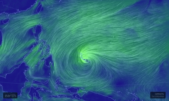
Tropical Storm Jelawat developed in the West Pacific on Sunday, however, it is not expected to threaten any major landmasses.

Future Track Details

The center of Jelawat passed in between the island nations of Micronesia and Palau on Monday. The Micronesian island of Yap Island picked up over 180 mm of rain early this week as the center passed off to the west.

The storm will track northward through Wednesday, and then get steered toward the northeast thanks to a cold front moving southward from Japan.

West Pacific tropical outlook through this week

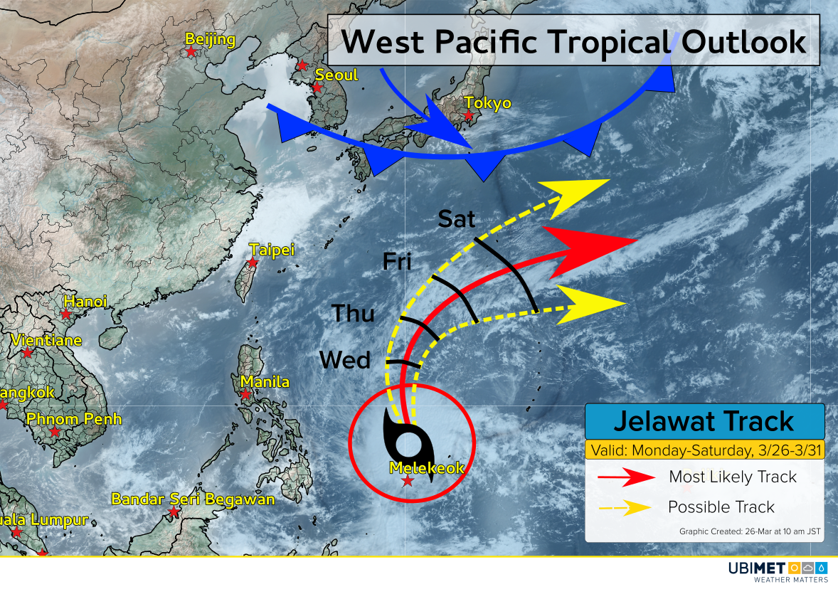
The expected curve to the northeast will keep the center of Jelawat far from any major landmasses.

Later this week, east-facing coastal locations of the Philippians, Taiwan, northward to Japan should expected to see rough surf. Direct wind and rain impacts are not expected.

Will Jelawat Strengthen?

Warm ocean water temperatures of 27-29°C have allowed Jelawat to acquire tropical characteristics. However, as the cyclone continues northward it will encounter stronger westerly wind shear. The wind shear will have a negative effect on Jelawat, and weakening is expected beyond Wednesday.

Global sea-surface temperatures. Jelawat is located within the blueish-purple circle.

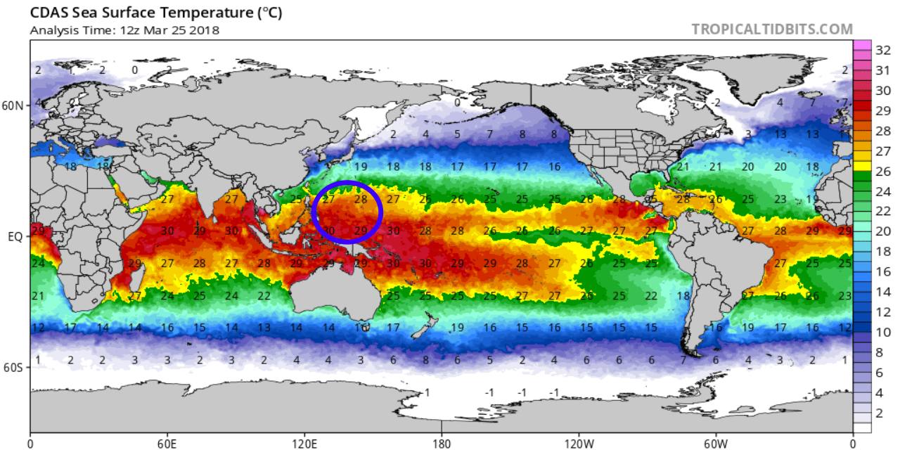
Once the Jelawat turns toward the northeast, the cyclone is expected to lose its tropical characteristics as wind shear increases and sea-surface temperatures cool to below 25°C.

California’s Sierra Ski Resorts Taking a Pounding This Month

After a very quiet beginning and middle of the west coast ski season, things have picked up big time in March. A particularly juicy storm has dropped several feet of snow just in the past week or so! As you can see in the table below, this latest storm has more than doubled the base snow depth at several resorts, in some cases much more than doubled. Additional snows locally up to a foot can be expected in the next couple of days before the pattern dries out.

Mammoth Mountain was the big winner with the current storm, reporting 88 inches (224 cm), or more than seven feet, in the past seven days. That brings them up to 141 inches so far for the month of March. Compare that to the 106 inches they had tallied through the first six months of the season (see graph below). The 35 inches the mountain saw on 22-March was a higher amount by itself than any previous month except for January (36 inches). The 141-inch total so far is already the fourth-most snowfall the Mountain has seen in March in the past 50 years with still another week to go.


Nora Intensifying Quickly as it Approaches Northern Queensland!


Severe tropical cyclone Nora has intensified to Category Three status over the warm waters of the Gulf of Carpentaria. Nora is compact so conditions remain relatively tranquil along the coast as of late Saturday morning. However, conditions will deteriorate quickly later Saturday afternoon into the overnight, especially from Aurukun south. Nora is expected to turn south near the western coast of the Yorke Peninsula and slow down, possibly even stalling over the southeastern Gulf or the adjacent coast for a day or so!


The heaviest impacts will fall on the coast from Aurukun down to Carpentaria. In this region, winds could gust up to 200 kph or more, leading to severe structural damage and widespread power outages. Rainfall up to 500 mm will also occur, leading to flash flooding. A moderate storm surge will affect the immediate coast, exacerbating any flooding issues.

Nora or its remnants will be slow to exit the region. Later next week, the circulation could move westward across NT and WA, producing locally heavy rain and gusty winds. We’ll have additional updates in the coming days!

Topsy-Turvy March Weather Courtesy of Unusual Atlantic Pressure Pattern

Through the month of February, residents of the Northeast could afford to chuckle at the “six more weeks of winter” promised by the fabled groundhog. Many cities reported among their warmest Februarys ever with clear days and little snowfall.

Then March hit. In the last 3-4 weeks there have been no less than four major Nor’Easter storms, bringing record snowfall and frigid temperatures. The table shows average temperatures for the major cities – note that March so far has been two to three degrees colder than February (all temperatures in deg Fahrenheit). Other areas of the globe have seen anomalous weather as well, from bone-chilling cold and snow in Europe to record warmth in the Arctic Circle.


One major factor that could help explain the topsy-turvy weather pattern is a particular phase of the North Atlantic oscillation, or NAO. The NAO is a fluctuation in surface pressure patterns over the Atlantic ocean. During much of February the NAO was in its positive phase (see graphic below), a situation that usually results in quiet, mild weather. However, from late February into early March the NAO plunged into deeply negative territory. In the negative phase of the NAO, the upper level jet stream that moves storms and air masses around becomes highly amplified. Warm air from the tropics can rush north into the Arctic, displacing frigid air down to the south over eastern North America or Europe. This turbulent pattern promotes more frequent development of winter storms over the U.S. Eastern seaboard and western Europe.


The NAO is currently forecast to trend a bit more towards the neutral phase. That combined with lengthening daylight hours should finally bring winter to a close in the next few weeks. But those that were fooled by the mild February have learned their lesson.