Tropical Disturbance Will Bring More Heavy Rain to the Southeast U.S.


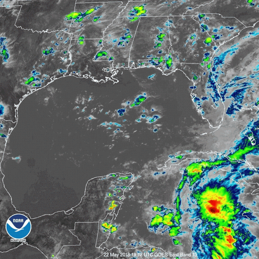
We’re monitoring a tropical disturbance currently hovering over the western Caribbean, just east of the Yucatan Peninsula. It’s part of a train of tropical moisture pumping up into the eastern U.S. Heavier than normal rainfall has been occurring for more than a week and is likely to continue for another week or more. But will there be the added threat of tropical storm development?


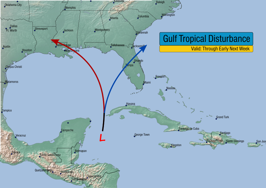
Model guidance is split on how this system will evolve. They agree on the possibility of some tropical development, despite how early we are in the season. In fact the hurricane season doesn’t even start until June 1st. However, a few tropical storms have been known to develop earlier. Some of the models turn the system towards the northwest and the central Gulf; others bring it more northeast towards Florida and the Carolinas.

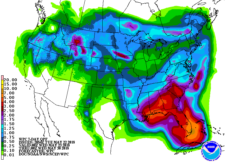
Regardless of whether or not the system intensifies to tropical depression or storm status, the moisture associated with the system will enhance already heavy rainfall in the southeast. The map below from NOAA’s Weather Prediction Center shows forecast rainfall amounts through the next seven days. You can see the heaviest rainfall amounts of 6-10 inches (150-250 mm) likely to impact coastal zones and the Florida peninsula.


UPDATE: Major Storm Still on Track to Slam Western Australia Late This Week!


Today’s model guidance and satellite trends continue to suggest significant heavy rains and winds are heading for western and southern WA starting Thursday. Expect strong thunderstorms to move in late Thursday afternoon into the overnight which will carry the bulk of the rainfall as well as lightning, damaging hail, and enhanced winds.

Strong high pressure has been nearly stationary over the Bight for the past week or more. However, a large, strong trough will finally push the high pressure east. This trough and the associated surface front will approach the coast Thursday and move inland by Friday. Wind gusts of 60-80 kph will be common, with higher gusts to 100 kph probable for wind prone locations along the southwest coast, potentially including the Perth metro area. The Capes will see the highest gusts of 100-120 kph.


Most of the heavy rainfall will occur with the storms along the cool front Thursday afternoon into early Friday. Rainfall rates could be 30-40 mm / 3 hours in this time frame. Considering the Perth airport hasn’t recorded more than 10 mm of rain in one day since January 16th, rainfall rates of that magnitude will likely lead to some localized flooding. We’ll have more updates as needed in the next few days. Lead photo courtesy flickr contributor Anthony Quintano.


Warm, Wet Pattern Will Persist Across the Eastern U.S.


A muggy, wet summertime pattern has set up across much of the eastern half of the U.S. over the past several weeks. Persistent southerly flow has been pulling moisture up from the Gulf of Mexico and the tropical Atlantic. The result has been two to four times the normal precipitation amounts from Florida up to the Mid-Atlantic since late April (see graphic below courtesy the Climate Prediction Center). Long-term trends and model guidance indicate this pattern will continue through much of the summer.


One of the prime mechanisms controlling long-term climate forecasting is the ENSO (El Nino Southern Oscillation), variations in sea surface temperatures across the Pacific basin. Currently neutral, the ENSO will be trending more positive and could be designated an actual El Nino later this year. In the shorter term, the Madden-Julian Oscillation (MJO), a globe-circling wave of clouds and rain, will remain active. This pattern is sometimes associated with increased tropical cyclone activity in the Atlantic basin, which would tend to support the idea that rainfall will be above normal. Global models have been tending to generate cyclones in the longer range (two weeks out). Even if cyclones don’t develop (it’s a bit early to reasonably expect them), an open tropical moisture tap can be expected to continue.


The one- to three-month forecasts above reflect the expectations for continued warm, wet weather. Unfortunately, this enhanced rainfall will continue to miss the extreme drought now stretching from the Four Corners region into the southern High Plains (map below).


UPDATE: Large Hail, High Winds Pound the Plains Saturday Afternoon & Evening


Heat and humidity sparked severe storm development on Saturday from the Texas Panhandle through southeast Kansas and southern Missouri. As you can see on the radar loop below, the storms took a variety of forms, from individual supercells to bowing squall lines and multi-storm clusters. Several reports of hail in the 2-3 inch (7.5 cm) diameter range were received, along with wind gusts of 70-75 mph (120 kph). At least one tornado touched down with a long-lasting severe cell in northern Oklahoma in the mid-afternoon.


Despite indications from model guidance on Friday, severe storms never developed from Topeka, KS through Kansas City to northern Missouri and southern Iowa. Instead, the corridor of severe storms ended up being from the Kansas-Oklahoma border to southern Missouri. These severe storms sapped unstable energy that otherwise might have fueled storms further north.