Australia Experiences Coldest Week Of Year So Far

The winter solstice arrived in the southern Hemisphere on Thursday, 21-June at 10:07 GMT. For Australia, it was appropriately marked by an unseasonably cold week for many locations.

Earlier in the week, a polar maritime air mass drove northward across the eastern half of Australia all the way to the QLD coast thanks in part to a strong storm spinning between NSW and New Zealand.

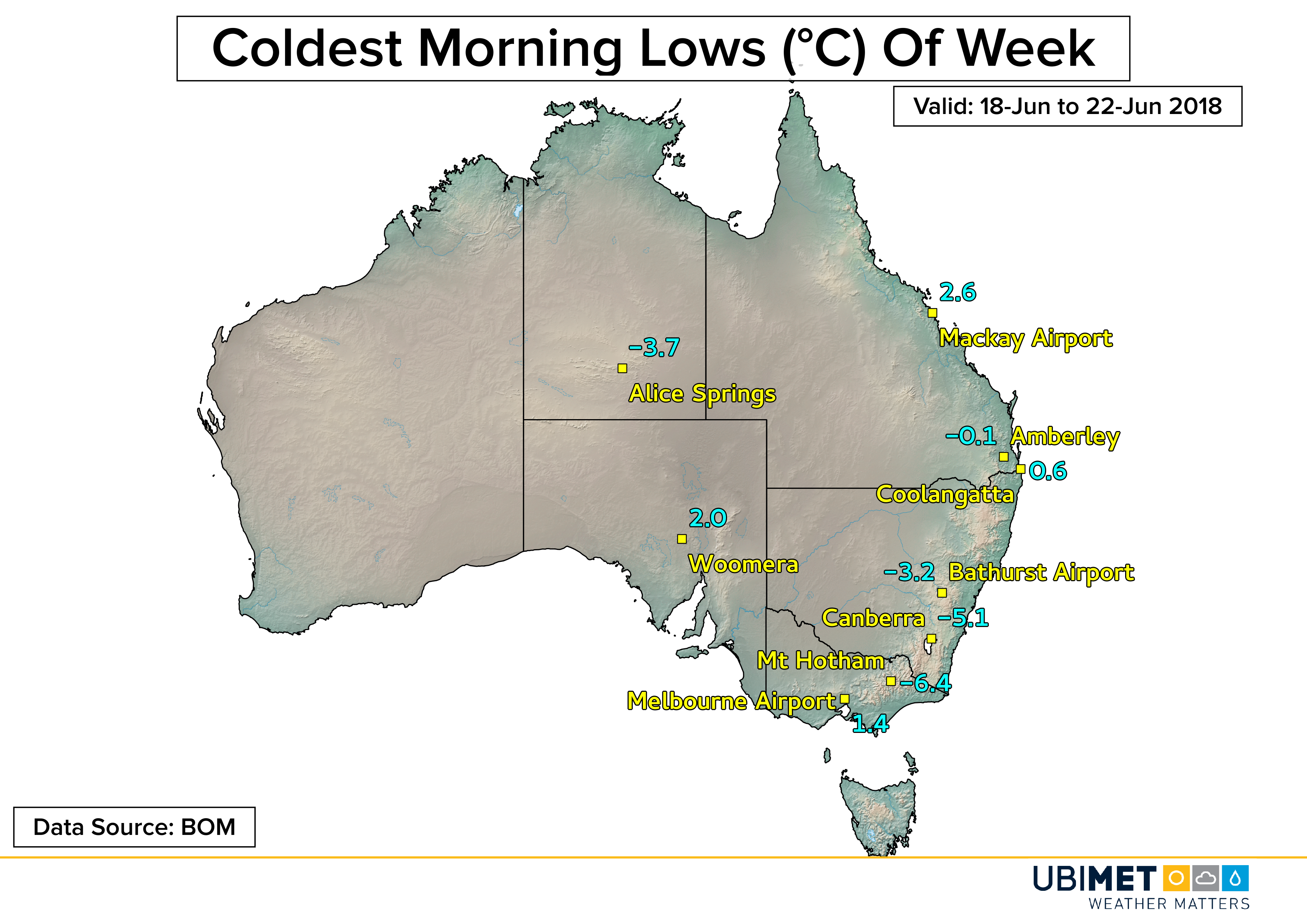
The Monday morning low at Coolangatta, Queensland bottomed out at just 0.6°C setting a new monthly record low temperature for June. The temperature was the coldest reading in Coolangatta since 15-August, 2008 when the temperature also fell to 0.6°C. The average June low temperature in Coolangatta is 11.4°C.

Farther north at the Mackay Airport the temperature got down to 2.6°C on Tuesday morning. That was only 0.9°C away from its June record low of 1.7°C set on 2-June, 2000.

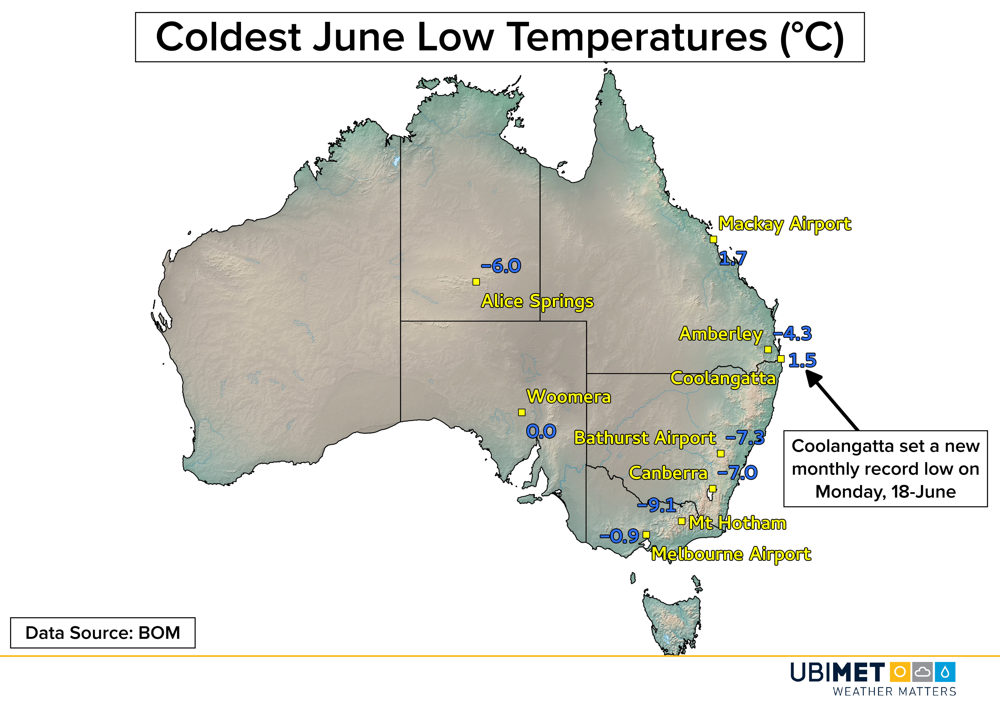
Across New South Wales and VIC, many communities away from the immediate coast saw temperatures drop to frosty and freezing levels. In Canberra, the recorded temperature fell as low as -4.7 Friday morning. Surrounding towns were even colder.

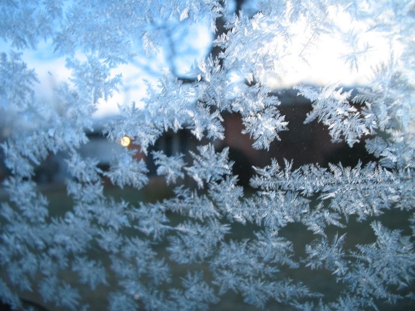
Even in the notoriously hot desert region of central Australia the overnight temperatures plunged below 0°C most nights. Alice Springs bottomed out at -3.7°C Tuesday morning. The below freezing temperatures made for some rare wintry-looking photos from the desert.

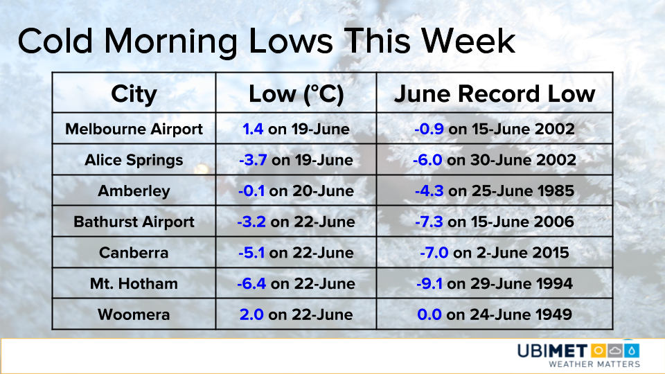
For some more detailed statistics on the recent cold stretch of weather, check out the table below.

Temperatures this weekend are expected to still tilt below average for most locations in southeast Australia. This is due to a cold front crossing TAS and bringing in a fresh air mass from the south.

2018 US Climate: Wet & Warm Weather Dominates

The 2018 summer solstice began at 10:07 GMT on 21-June in the northern hemisphere. Since the start of the solstice is close to the halfway point of the year, it marks a good time to check in on the state of the climate so far in 2018.

The maps and information below were compiled by Ubimet using close to 900 stations across the United States. The data from these stations compare 2018 observations to historical climate data with a record period of at least 30 year or more.

Precipitation:

Wetter than average conditions have dominated many locations from the northern Rockies eastward to the Midwest, Northeast, Mid-Atlantic, and Florida.

February was a particularly wet month from the Mississippi Valley up into the Mid-Atlantic as precipitation surpluses ranged from between 200-300% of normal.

The Southern Plains and Southwest have largely been drier than normal, which is not good news for the ongoing drought in these area. January and April were particularly dry months for these regions.

The next map below takes a look at stations which are experiencing a top 5 driest or wettest year so far through 20-June. Stations experiencing a top 5 wettest year outnumber those with a top 5 driest year by a greater than 2:1 margin.

Temperature:

Warmer than average temperatures have dominated much of the United States through the first half of 2018. Communities from the West Coast to the southern Plains to the East Coast have largely been warmer than the long-term average.

There have been some colder than normal pockets that extend from Montana into parts of the Midwest; and a second area across the Appalachians. However, out of the 822 stations with temperature data only 16.7% are colder than their long-term average.

The last map below takes a look at stations which are experiencing a top 5 coldest or warmest year so far through 20-June. Stations experiencing a top 5 warmest year outnumber those with a top 5 coldest year by a 23:1 margin!

The temperature trend observed in the United States through the first half of 2018 is consistent with the latest IPCC assessment which concludes that the Earth as a whole is warming.

Keep an eye out for more climate-related information and visual content from Ubimet in the coming weeks and months.

Tornado Observed close to Denver Airport on Tuesday

An outbreak of severe thunderstorms on Tuesday afternoon produced a tornado that was observable from Denver International Airport (DIA).

A cell tower camera at the airport captured an image of what was later confirmed to be a tornado.

A reanalysis of radar imagery from the storm shows that the tornado touched down about 15 miles (25 km) north of the airport. The black arrow in the follow image indicates approximately where the tornado would have been.

Additional storms fired in the Denver area during the later afternoon and evening hours prompting hundreds of arrival and departure delays at the city’s international airport.

Other Severe Storm Reports

Denver was not the only city targeted by severe weather on Tuesday. There were other severe thunderstorms across eastern Colorado and other areas of the High Plains that produced many instances of large hail.

Hail up to the sizes of tennis balls and tea cups (2.5 to 3.0 inches) were observed in Arapahoe County, Colorado, which sits to the southeast of Denver.

Some twitter users posted videos showing copious amounts of hail falling from a thunderstorm. Two of the more impressive video tweets are shown below.

Wednesday will bring quieter weather to the High Plains as the storm system responsible for the severe weather moves out of the region.

Monday Recap: Northeast hit with Record Heat and Severe Storms

A hot and muggy air mass provided ideal conditions for record-breaking temperatures and scattered severe storms across the Northeast on Monday.

Record Temperatures

Unofficially, 18 record highs from the Midwest to the Northeast were tied or broken on Monday.

At Washington, D.C. Dulles Airport, the high of 94 degrees tied a record from 11 years back in 2007. Elsewhere, highs in the middle 90’s across central Pennsylvania and southern New York state broke several record highs, many of which were from the 1990’s.

A cold front will drop through the Great Lakes and Northeast on Tuesday bringing some relief from the heat and humidity. Across the southern Mid-Atlantic and Carolinas, Tuesday will end up hotter than Monday in some cities as the cold front will remain north of the area.

Severe Weather

In addition to the hot weather, an abundance of moisture in the atmosphere help fuel several clusters of severe thunderstorms across the Northeast.

There were a total of 191 wind and hail reports recorded by the Storm Prediction Center from Ohio to Virginia northward to Maine.

Many of the wind reports featured downed trees and power lines. In Poughkeepsie, NY, strong winds from severe thunderstorms lead to a building collapse injuring one person that was inside. Across southern Maine, severe storms knocked out power to thousands of customers.

One of the most impressive storms of the afternoon was a potential tornado producing storm across southern New Hampshire.

In the wake of Monday’s severe weather, the Northeast will get a break from the severe weather on Tuesday as the cold front brings in a drier more stable air mass.