More Heavy Rain and Mountain Snow for Oregon and Northern California!


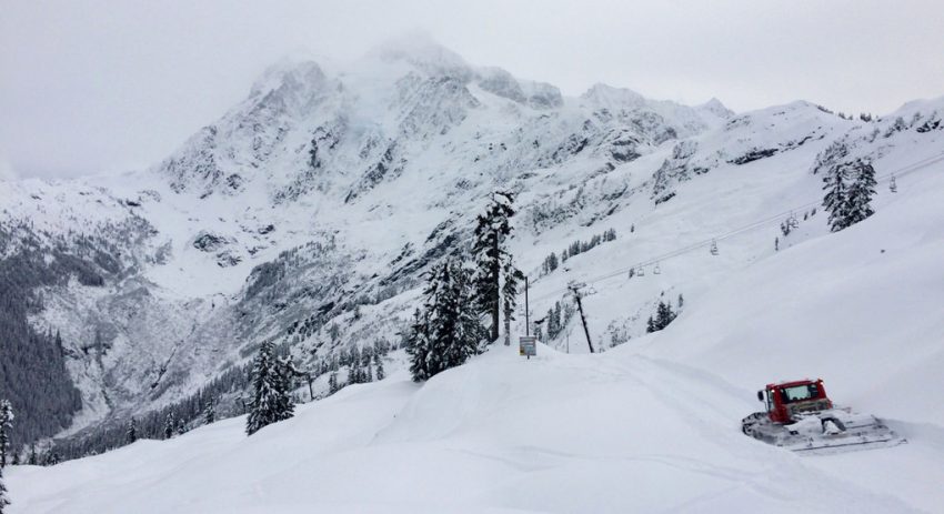
A deep Pacific moisture tap continues to slam portions of the west coast. Heavy rain is flooding the lower elevations with crippling snow in the mountains. Rivers have surged to levels not reached in decades, while ski resorts face the unhappy prospect of having too much snow to operate.

The latest storm system dropped heavy snows even in the relatively low-lying Willamette Valley of central Oregon. An Amtrak train was stopped for 37 hours with 183 passengers on board by a downed tree due to the heavy snow just outside Oakridge, OR. Up to 18 inches of snow was reported in Eugene, one of the biggest storms on record. The storm then moved south into the northern half of California. Mt. Shasta reported upwards of 70 inches of accumulation in a 48-hour period. The snow was enough to bury ski lifts, shutting the popular ski resort there down. Similar accumulations pounded portions of the Sierra Nevada range. Squaw Valley ski resort has recorded 300 inches in the month of February, the snowiest month on record. For the season, they’ve seen 557 inches, or more than 46 feet!


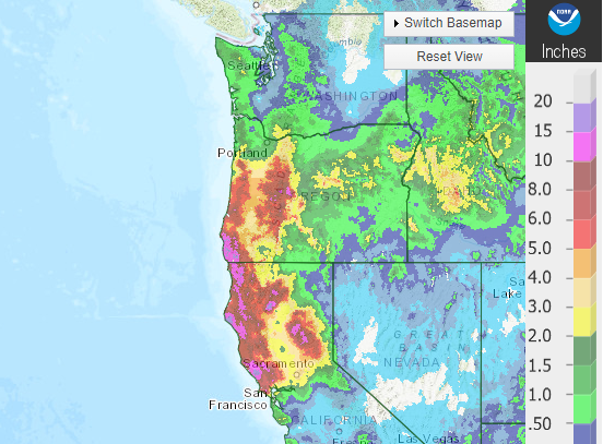
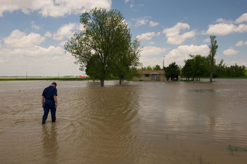
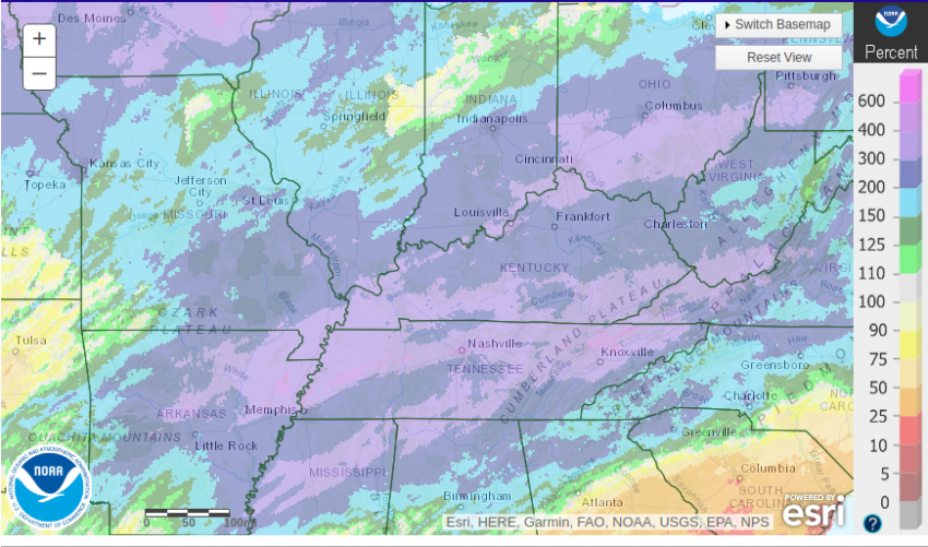
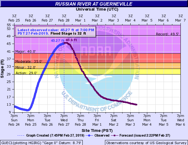
The issue for lower elevations has been persistent heavy rain. West-facing foothills and coastal areas of northern California and southwest Oregon saw widespread 6-12 inch rainfall amounts since last week, locally higher (see map above). The Russian River at Guerneville rose from near 10 feet on Monday afternoon to more than 45 feet by Wednesday evening (see graphic below), flooding much of the town and forcing thousands to evacuate. Indeed, all roads in and out of Guerneville and nearby Monte Rio are now impassable, totally stranding any residents who stayed behind. Fortunately, the region will enjoy a few days of dry weather to begin to recover. Lead photo courtesy flickr contributor Peter Stevens.


Major Flooding Inundates Towns Along the Ohio and Mississippi Rivers!


Torrential rains have slammed portions of the Midwest and Tennessee Valley through much of February. Runoff from this excess rainfall has pushed local streams and rivers well above flood limits. These floodwaters are now starting to feed into the major rivers of the region. Gauges all long the Ohio and Mississippi Rivers are entering the major flood stage!


The graphic above shows rainfall has been two to four times normal values since February 1st across the region. Nashville, Tennessee has seen 13.47 inches of rain through February 23rd, the most ever recorded in the month of February. Likewise, Huntsville, Mississippi set a new record for the month with 12.6 inches. Memphis has reported measurable rain on fifteen days so far in February.


The excess water has been straining local dams and tributaries for the past few weeks. It’s now entering the major rivers, including the Ohio and Mississippi. Eight gauge sites are reporting major flooding in the region as of Tuesday evening, including three on the Ohio and one on the Mississippi. Seven more gauges further south along the Mississippi could join that list in the next few weeks as the floodwaters surge downstream. Many of the sites that are already seeing major flooding will not begin to recede until this weekend or beyond. Officials in Paducah, Kentucky have added flood gates to the wall protecting the downtown from the Ohio River (top tweet above). Sandbags are helping reinforce the wall at key points. Unfortunately, rural areas nearby often can’t be afforded the same protective measures and face inundation (see tweets above). Lead photo courtesy Isaac Pacheco, US Coast Guard.


Damaging Winds Sunday and Monday Across the Midwest, Great Lakes and Northeast!


A large, strong area of low pressure moving across eastern Canada produced very strong winds from this weekend into Monday. Areas of the Great Lakes, Midwest, and Northeast as well as southeast Ontario were hardest hit. Gusts exceeding 60 mph (100 kph) were common across the region with some areas seeing gusts of 80-100 mph or higher!


Mt. Washington, typically the windy spot in the Northeast U.S. saw a gust to 171 mph (275 kph), setting a new record for the month of February. Gusty winds toppled numerous trees, powerlines, street lights, and semi-trailer trucks. Strong westerly winds pushed chunks of ice onshore over portions of the Great Lakes (see video above). Already fallen snow was whipped around by the winds, leading to dangerous whiteout conditions that in some places rivaled the March 1993 Superstorm. Fortunately, winds have begun to subside as of Monday evening. Lead photo courtesy Wikipedia contributor James Marvin Phelps.

Rare Snowfall for Desert Southwest, Including Sin City


An unusually cold air mass has been anchored across much of the western U.S. in recent weeks. A series of significant troughs has been rotating through, pushing Pacific moisture into the cold air. The result has been snow falling on areas unaccustomed to seeing flakes fly. Some particularly beautiful scenes have been captured in the bright lights of Las Vegas over the past week.


The first shot of accumulating snow came through Vegas on Sunday evening. A dusting fell on most of downtown, but western suburbs saw 1-2 inches of wet accumulation. A much larger, stronger trough has come in for the late week, producing off-and-on snow from late Wednesday well into Thursday. Slushy accumulations of 0.5-1 inch were tallied for parts of the Vegas downtown, enough for residents to build some tiny snowmen for the first time in their lives! McCarran International Airport reported 0.8 inch of snow for the day, the most in more than a decade. Western and southern suburbs fringing on the mountains saw accumulations of several inches. It was enough to prompt for officials to call a rare snow day for Clark County schoolchildren.


Other areas of the Southwest have seen unusual snow amounts as well. Chilly temperatures in the L.A. Basin led to reports of wet snow flurries in Malibu, Pasadena, and Calabasas. Interstates running through the mountains ringing Los Angeles were closed due to heavy snow and icy conditions. Kingman, Arizona, a city more commonly known for withering summertime heat, reported 12-18 inches of heavy snow. And Flagstaff set a new daily record for snow accumulation on Thursday, up to 33 inches and counting as of Thursday evening. The storm system responsible for the desert snows will eventually emerge into the Plains with a threat for blizzard conditions and severe storms this weekend. Lead photo courtesy Wikipedia contributor Jake DeGroot.