Tropical Storm Barry Already Flooding New Orleans Days from Landfall


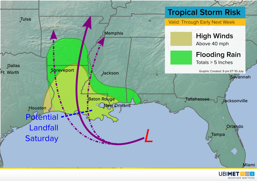
The tropical low that moved into the northern Gulf earlier this week strengthened Thursday to become Tropical Storm Barry. The second named storm of a fairly quiet 2019 season thus far, Barry is taking aim at coastal Louisiana. Further strengthening is expected and Barry could be a hurricane as it approaches landfall!


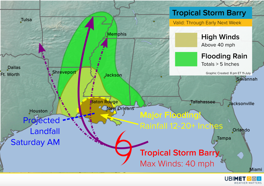
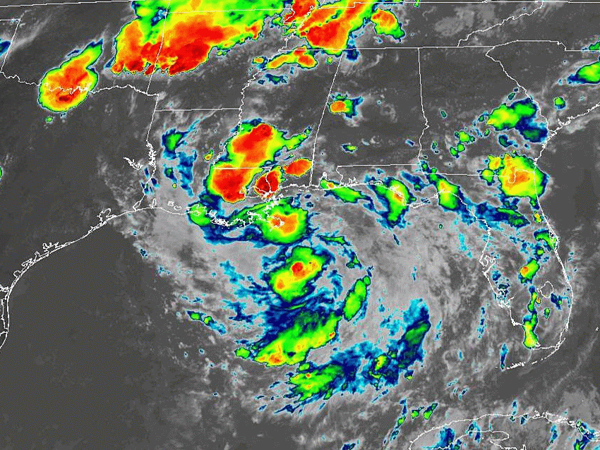
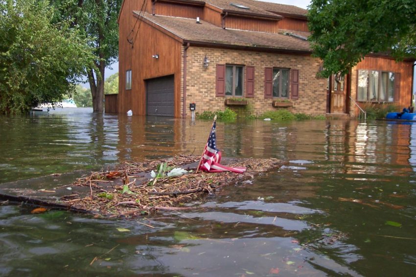
Louisiana is no stranger to hurricanes, but this would be the first to strike since Hurricane Isaac in 2012. Barry will bring a risk for damaging winds exceeding 40 mph and a significant storm surge locally up to five feet. However, the most widespread and dangerous threat could be flooding rainfall. The storm is in no hurry, crawling westward at about 5 mph. This slow forward movement combined with rich tropical moisture being wrapped in to the storm’s center will mean days of torrential rain. Totals of 12-18 inches (300-450 mm) will be common across southeastern Louisiana. Localized totals up to of 24 inches (600 mm) are likely! Serious flooding has already been occurring in the New Orleans area (see tweets below). The Mississippi River is expected to rise to levels not seen since 1950 in the New Orleans area.


A state of emergency has been declared for parts of Louisiana, and mandatory evacuations are in effect for some coastal communities. However, neighboring states will see significant wind and especially rain impacts as well. The worst impacts from wind and storm surge will be felt along coastal Louisiana from late Friday into Saturday. However, the freshwater flooding threat will stretch well into early next week for the entire Lower Mississippi Valley.

Tropical Disturbance Has Gulf of Mexico Residents on Edge


An area of low pressure, which began as a cluster of thunderstorms over the Midwest several days ago, has now drifted into the northern Gulf of Mexico. Although it has not yet developed a defined center of circulation, the ingredients are coming together for significant strengthening. By the late week or this weekend, a tropical storm or even hurricane could be menacing the Gulf coast!


The low pressure area has a decent presentation on satellite imagery (notice the swirl of clouds in the animation above). It’s already producing torrential rains along the Gulf coast. These rains will continue to cause serious flooding issues as the low moves slowly west over the northern Gulf. Water temperatures in this area are very warm, in the upper 80s deg F (lower 30s deg C). Upper level winds are also quite favorable for tropical cyclone development. If the system can organize a bit more in its core, these ingredients will enable rapid intensification.


Model guidance is still somewhat undecided since the system remains poorly organized. Some guidance brings the storm to the west, some to the east. Likewise, intensity forecasts vary. However, there is starting to be some agreement on a track initially towards the west and then eventually north. A potential landfall looms along the coast of Louisiana by Saturday. As long the center organizes sufficiently into Thursday, that still leaves a 36+ hour window for rapid intensification. Some models even suggest the system could be a hurricane by early Saturday. Regardless of whether it’s a weak hurricane or a strong tropical storm, significant impacts can be expected in the form of flooding rains, damaging winds, and a life-threatening storm surge. The map above shows the area likely to see wind and rain hazards.

Heat Wave for the Ages Affecting Normally Mild Alaska


The Fourth of July is traditionally known as a warm weather holiday across much of the United States. For many it represents the beginning of the summer. Residents of Alaska usually enjoy relatively cool temps during the traditional fireworks shows. But this past Thursday was not only the hottest Independence Day on record for the northernmost state in the union. Several stations reported their warmest temperatures for any day ever!


The average high for early July in Anchorage, the largest city in Alaska, is in the mid-60s deg F (upper teens deg C). Located on the shores of the always-chilly Gulf of Alaska, it’s a rare summer day that approaches 80 deg (27 deg C), and the all-time record high for any day was 85 deg F (29.4 deg C). That is, until Thursday. The official high reached 90 deg F (32 deg C) in Anchorage, with several other stations across the southern part of the state setting new all-time high marks (see map above, courtesy of the National Weather Service).


A strong, persistent ridge of high pressure is responsible for the hot weather. Alaska has been well above normal for close to two months now. Average temps in June ran five degrees above normal. The hot pattern is expected to continue for the next several days; Anchorage was only spared another record-shattering high temperature on Friday by the cover provided by wildfire smoke descending on the city. More records are likely to fall through early next week.

Major Hurricane Barbara Spins Across the Eastern Pacific; Atlantic Basin Still Quiet


Residents along the Pacific and Atlantic coasts enjoyed a very quiet beginning to the 2019 hurricane season. June, the first month of the official hurricane season, is typically quiet anyway. However, this will be the first year since 2009 featuring no storm activity in the first five weeks of the season. It’s a different story in the eastern Pacific, though.

A tropical depression developed on Sunday over the open waters of the eastern Pacific and was named Barbara by the afternoon. Barbara has steadily gained strength and is now a major hurricane, producing sustained winds to 130 mph ( kph). That’s a potentially very dangerous storm. Fortunately Barbara is not projected to affect any land masses. The storm will continue to move west and northwest, eventually dissipating late this weekend into early next week.


No tropical activity has been detected in the Atlantic basin since Subtropical Storm Andrea’s brief existence in May. The ENSO (El Nino – Southern Oscillation) remains in the positive mode (see graphic above). In other words, warmer-than-normal water temperatures over the western Pacific are resulting in stronger winds aloft. These winds act to disrupt developing tropical cyclones over the Atlantic basin. However, the ENSO is only weakly positive, and is forecast to remain that way. In addition, water temperatures are quite warm (see map below), which could provide fuel for cyclones later in the season.