Severe Weather Threat Continues For The Midwest

Breakdown:

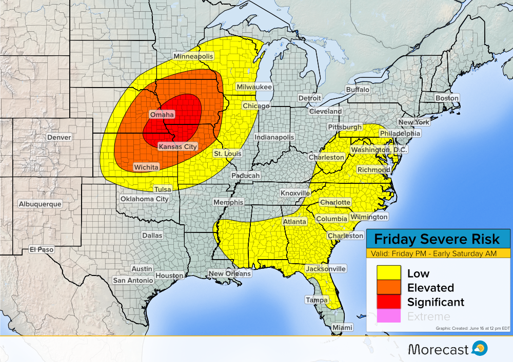
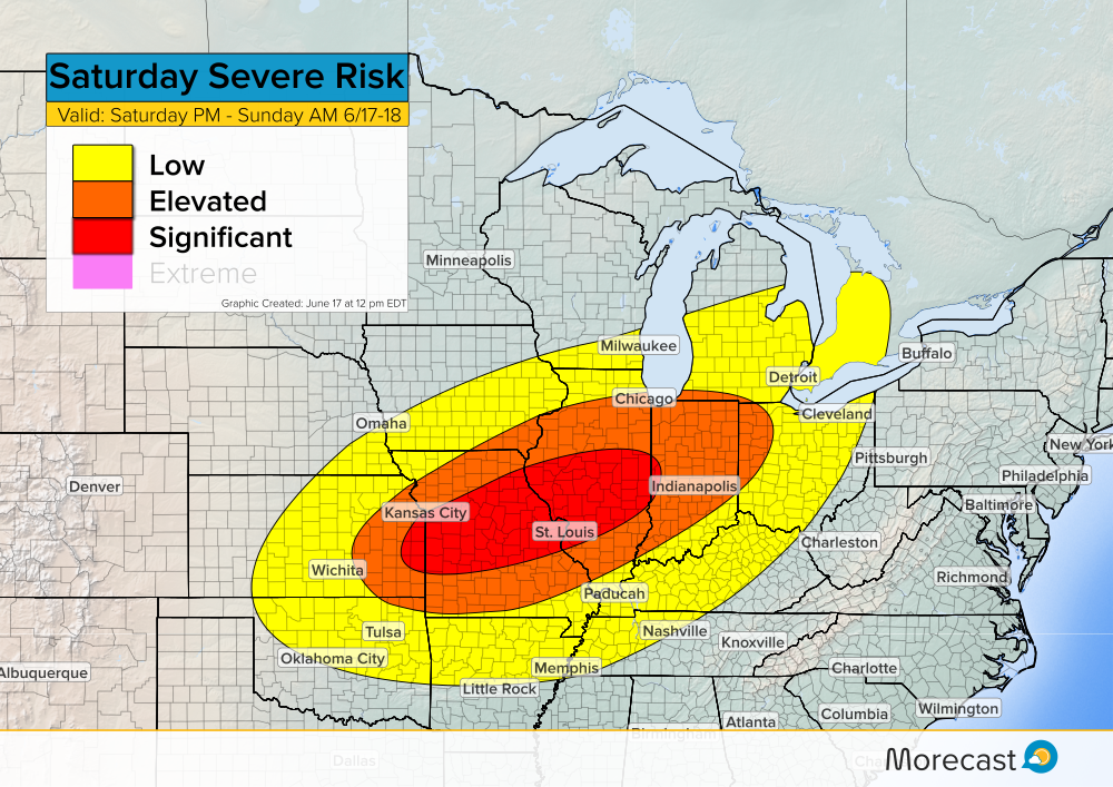
Another round of severe weather is expected Saturday afternoon and will last into Sunday morning. The threat area shifts south and east compared to those impacted Friday.

Currently, a surface boundary stretches from the Oklahoma panhandle up through central Kansas and into eastern Iowa. As this boundary slowly moves southeast during the afternoon hours, severe storms are likely to develop ahead of it.

Main Threats:

Similar to Friday’s severe storms, the main hazards on Saturday will primarily be large hail and damaging winds. Hail sizes could exceed 2 inches in certain areas and damaging wind gusts may exceed 70 mph. As storms develop, an isolated tornado threat may also exist.

When traveling, watch out for heavy rain and flash flooding. Take necessary action if severe weather approaches: secure loose outdoor items, move vehicles indoors, and relocate to a safe area.

Timing:

Storms are expected to develop in the mid afternoon hours around 3PM CDT and generally move from west to east.

Upload any storm related weather photos to the Morecast app if conditions are safe. Follow along with the Morecast Team via our Facebook and Twitter pages for updates on the severe weather.

For up to the minute forecasts for your exact location, be sure to visit our website.

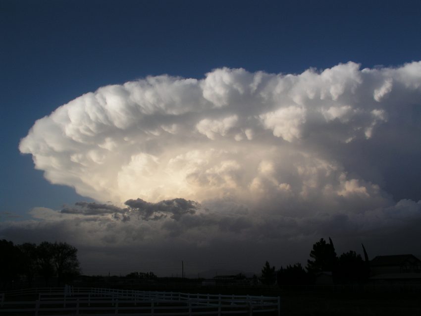
Featured photo taken by flickr user Lane Pearman in Severy, Kansas.

More Severe Weather in store for the Plains, Upper Midwest, and Southeast Friday

Synopsis:

After a round of severe weather impacted the Plains Thursday, some the same areas could be in for more Friday. A surface boundary currently positioned from western Minnesota down through eastern Colorado will slowly move east. Severe thunderstorms are likely to develop along this boundary from central Kansas up through southern Minnesota and push eastward. In the southeastern US, isolated severe storms are possible during the afternoon hours as daytime heating occurs.

Main Threats:

In the Plains and Upper Midwest, the biggest hazard will be large hail and damaging winds. Hail sizes could exceed 2 inches in diameter in some places and wind gusts could exceed 70 mph. Isolated tornadoes are not likely but cannot be ruled out. In the southeast, damaging winds remain a threat but the hail sizes should remain around an inch or less.

If severe weather strikes and conditions are safe, upload pictures to the Morecast app. Be sure to follow along with the Morecast team on our Facebook and Twitter pages for updates. For up to the minute forecasts at your exact location, be sure to visit our website.


Severe Storms set to batter the Plains and Southeast Thursday

A strong surface boundary has moved northwest into Central Kansas with a dry line extending south into the Texas panhandle. Dew points ahead of this system are currently in the low 70’s.

Severe Weather Details:

With mostly clear skies early Thursday afternoon, ample surface heating will allow for severe thunderstorm development. Storms are anticipated to fire between 1PM and 2PM CDT and could  become severe quickly.

The main hazards will be large hail that could exceed 2 inches in diameter, and damaging wind gusts. Conditions do not favor tornado development but there is an isolated risk.

Across the Southeast, ongoing storms Thursday morning will weaken by early afternoon. As conditions clear out, redevelopment is possible across the area. The main hazards will not be as significant as those in the Plains, but isolated damaging wind gusts and small hail may occur as well as frequent lightning.

If weather conditions are safe, upload your photos to the Morecast App. Feel free to following along on our social media platforms Facebook and Twitter as well as Morecast.com for the latest updates.

Slow sign of snow for the Australian ski resorts

After some decent early snowfall in the week leading up to the official start to the Australian ski season, the resorts look set to endure a lack lustre June with no new wintry falls on the horizon.

The season which runs from the Queen’s birthday holiday in June to early September can be fickle at the best of times culminating in brief periods of sizeable accumulations inter changed with longer episodes of reduced activity.

The following chart shows the coldest of the air contracted well south of the Australian continent, kept in check by a band a strong winds that circumnavigated the polar region.

A combination of the Earth’s rotation and lessening of the polar jet stream allow this colder air to surge northward in the form of undulating wave like patterns around the Antarctic continent

It is the associated cold air with these systems during the darker months that bring the prospect of wintry weather for the Australian ski resorts and even low levels also.

Interpreting the charts

The Thickness lines indicate the average temperature through the lower 5km or so of the atmosphere. They measure the distance in dekametres (tens of metres) between the 1000 and 500 hPa pressure levels.
The average distance is about 5.5km, or 5500 metres or 550 dekametres, which are the measures shown on the map.

Warm air is thicker than cold air, so lines marked 560 (or 5.6km) and above indicate that the bottom 5km or so of the atmosphere is fairly warm.

A thickness below 540 (or 5.4km) indicates a pretty cold lower atmosphere, and below 530 is really cold!

In colder air masses the freezing level is lower thus any frozen precipitation can reach the surface as snow without melting.

The 540 line highlighted in “blue” on this chart is often used as a rough guide to determine when an air mass is cold enough to produce snowfalls on the Australian Alpine areas.
The overlaid “white” hatched shading indicates where wintry precipitation possible down to surface level.

Any more Snow on the horizon

Present indications suggest the current pattern will remain in place for the rest of June with the more significant weather systems expected to continue to track well to the south of mainland, thus equating to little in the way of decent snowfall  on the forecast for the Australian ski resorts.