South western WA awaits wild Winter weather

Intense weather systems approaches far south western Australia

Wild Winter weather looks set to pummel south western WA over the coming days with gusts of 90km/h and thunderstorms with small hail also in the mix.


Locations at risk

After a relatively quiet period the weather is set to swing back into a much more tempestuous mood through the middle of week with much of the state’s far south western regions in the firing line.

Places from Perth to Albany including Bunbury and Manjimup will be all at risk to squally conditions over this period as a powerful cold front sweeps in from the west and a cold and very showery set up follows in it’s wake.


What is causing it

Intense weather systems approaches far south western Australia
The gathering storm: A large swathe of cloud associated with an intense low pressure system approaches the far SW coast of WA

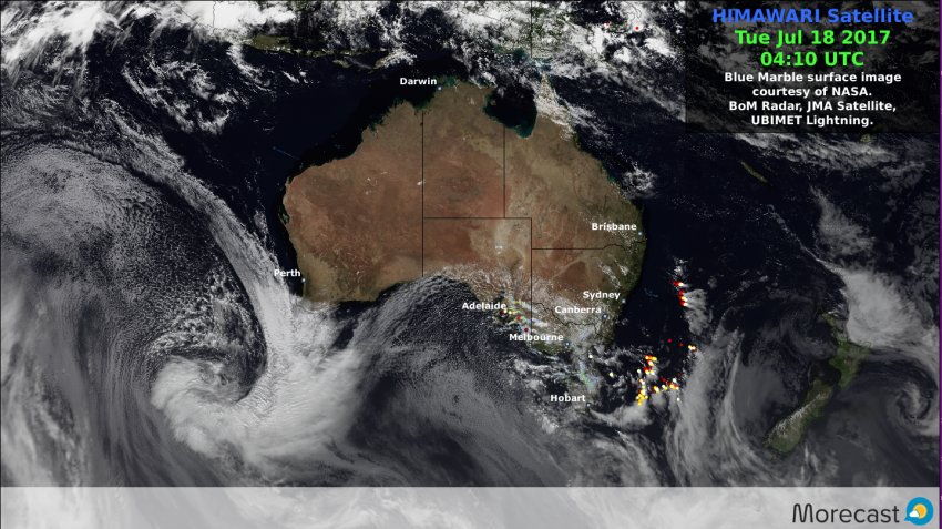
A large swath of cloud associated with a strong cold front is expected to push in across the far south western area later Tuesday.

While the associated deep low pressure system expected sweep bands of blustery showers across the region for Wednesday and again on Thursday, some of which are likely to be thundery in nature with small hail also possible.
Meanwhile gale force winds along the south coast combined with large swells will make for treacherous seas conditions here.


Outlook

The worst of the weather should ease through Thursday though another system is expected to approach the area once again on Friday, however at this stage it is not predicted to as intense as it’s predecessor.


Stay one step ahead of the weather with Morecast. Daily and hourly forecasts to any location Australia wide. Check out our Facebook and Twitter as well as Morecast.com for the all latest.
If you are out and about across South western WA over the coming days, why not check out the weather conditions along the way with the Plan your route feature.

Another Round of Severe Storms to Slam Upper Midwest: Tuesday, July 11

It’s been an active week of severe weather across the Upper Midwest, and another round is expected again Tuesday evening. The severe threat spans from Fargo down to Milwaukee, but it’s the I-94 corridor between Fargo and the Twin Cities with the greatest threat for strong to severe storms.

Timing

The first storms will develop in eastern North Dakota after 6 p.m. (local/central time) around the Fargo area before drifting into western Minnesota an hour or two later. These first storms will be individual cells, offering the greatest threat for potential tornadoes, along with large hail and damaging winds.

As the night progresses, the individual storm cells are expected to form into a larger cluster or complex of storms. The good news is that this will help diminish the tornado threat as the complex moves east into the Minneapolis metro area and northwest Wisconsin, arriving there around midnight local time. However, this complex will have a lot of moisture to work with, meaning a high risk for torrential rains and flash flooding, with locally damaging wind gusts capable of knocking over trees and power lines. These storm complexes usually produce a high density of lightning strikes. So for many, it will be a bright and loud overnight as the storms move through the area.

There’s also a good chance for a second cluster of storms to develop after 9 p.m. across southern Wisconsin, impacting areas between Madison and Milwaukee. While likely not as intense or as strong as the storms expected in Minnesota and northwest Wisconsin, a few of these storms could still become severe with quarter size hail, strong winds and heavy rain.