Deadly Flooding in Northern Vietnam Thanks to Slow-Moving Tropical Storm

A season’s worth of rainfall has fallen over the past week in portions of northern Vietnam. A slow-moving, back-tracking tropical storm has caused severe flash flooding. Many homes and roads have been destroyed in several provinces, and the death toll has risen to at least 20.
Where is my bike? 😬Flood in #Vietnam pic.twitter.com/G9VAhDeJ04
— bangkok charlie (@bangkokcharlie) July 22, 2018
Vietnam nation road. Ya, right, road not river!! 😂😂#flood in #vietnam#swim on the #road pic.twitter.com/TV9Qr3JDRe
— Chris (@truongsagicorns) July 23, 2018
Tropical Storm Son-Tinh developed last week over the Western Pacific. The storm never gained much intensity as it moved west, skirting the northern Phillippines before crossing over China’s Hainan Island. It gained some strength, though, as it crossed the Gulf of Tonkin on 18-July. At the same time it slowed down and performed a three-day loop over northern Vietnam and adjacent Laos. The storm has been persistent and is now moving back over Hainan Island as of Tuesday morning.
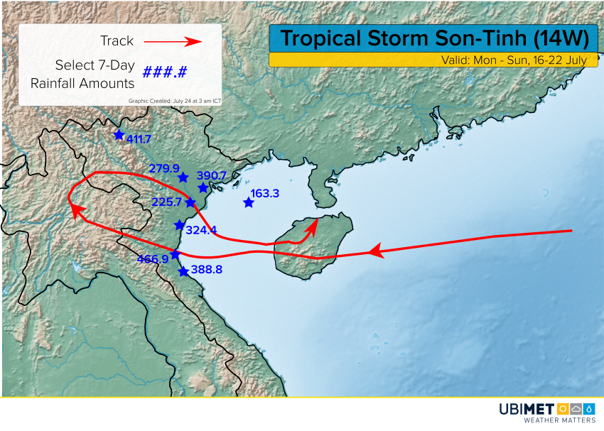
The creeping progress of the storm has meant days of heavy, tropical rains. Above is a map with the storm track and select rainfall amounts (in mm) between 16-July and 22-July. The 466.9-mm total at Vinh is roughly equivalent to their normal rainfall from June, July, and August combined! The worst flooding has occurred in Yen Bai, a province of interior northern Vietnam characterized by steep mountains, increasing the danger of land and mudslides. Fortunately, the heavy rains subsided later on Monday.