#Man killed in fight over water as India grapples with heatwave https://t.co/dVVlcPFhn3 #news pic.twitter.com/CiyU2VusQO
— 💛💙LegoLASS💚🏳️🌈 (@MouseTr1) June 7, 2019
Delayed Monsoon Intensifies Indian Heat Wave & Water Crisis
After a brief reprieve, more hot, dry weather is building across parts of central and northwest India. This new heat wave will only exacerbate severe drought conditions and water shortages. Some cities are being forced to truck water in from other locales due to water reservoirs being nearly bone-dry, a tremendously expensive operation.
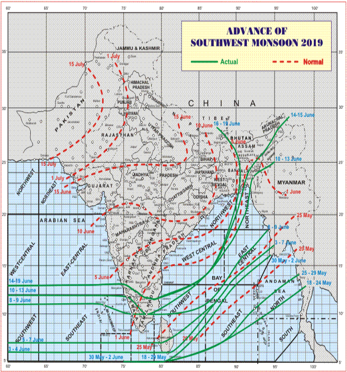
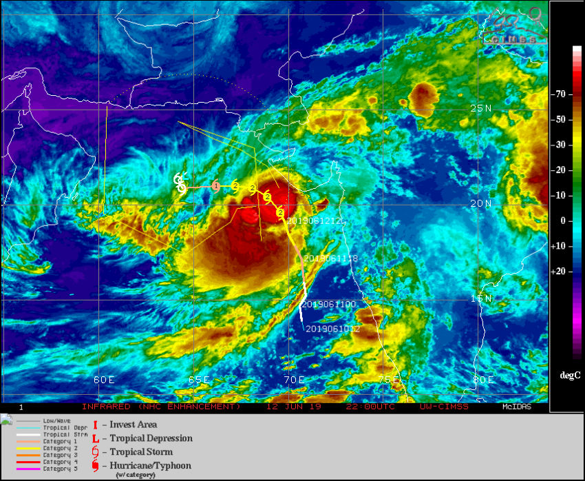
Cyclone Vayu clipped the western part of India last week. Fortunately, the coast was spared the worst winds and surge flooding. Parts of the country even received welcome rain and cooler temperatures. However, the cyclone also sapped the developing monsoon trough of moisture and energy. The result is an already-delayed monsoon stalling in the far southern and eastern portions of the country. As of 20-June, only about 10-15% of the country has seen the onset of the monsoon, compared to two-thirds normally by this time (see map above). While the monsoon is beginning to creep northwesterly again, it will be several weeks yet before it reaches the west and northwest regions. For a largely agrarian country that receives 70% of its rainfall from the monsoon, the delay is devastating.
Some satellite images of the ongoing water crisis in #Chennai, #India courtesy of @Maxar. No significant relief during the SW monsoon; climate models not optimistic for the NE monsoon in boreal #autumn either. pic.twitter.com/SLwWMgVNEJ
— Jason Nicholls (@jnmet) June 19, 2019
Chennai water: How India’s sixth biggest city is coping with shortages https://t.co/rEz7tBlS1E
— BBC News (World) (@BBCWorld) June 20, 2019
The delay may be partially due to the ingoing El Nino, a pattern of warming waters in the Pacific that has global impacts on weather. However, scientists also fear a weaker and more unpredictable monsoon due to climate change. Some regions have seen successive weak monsoons, combined with human-driven factors, result in severely depleted water supplies. Chennai, the sixth-largest city in India, home to more than 4.5 million people, is one such city. Officials there have had to employ 400 tanker trucks to deliver thousands of cubic feet of water to local reservoirs which are otherwise spent. But a nation-wide monsoonal delay reduces the ability of neighboring regions to help, creating a crisis everywhere.