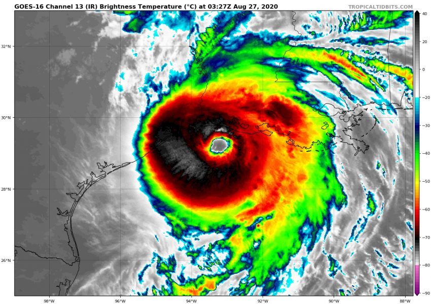
Hurricane Laura Rakes Through Louisiana!
Hurricane Laura roared ashore around 1:00 am Thursday morning near Cameron, Louisiana. The Category 4 storm contained winds of 150 mph (241 kph) at landfall, making it the strongest storm on record to strike southwestern Louisiana. It is also tied with the Last Island Hurricane of 1856 for strongest storm at landfall to hit the state, and is the fifth strongest hurricane on record to landfall in the continental United States. With a central minimum pressure of 938 mb at the time of landfall, it is the fourth lowest pressure recorded in Louisiana history. Before landfall, Laura’s winds rapidly intensified 65 mph (105 kph) in 24 hours, tying the record set by Hurricane Karl in 2010 for fastest intensification rate in the Gulf of Mexico.
#VIDEO: Aerials show some of the damage from Hurricane Laura in Lake Charles, Louisiana. @WKRN pic.twitter.com/cENi0gAiXy
— Josh Breslow (@JoshBreslowWKRN) August 27, 2020
Records aside, Laura has absolutely decimated many towns across southwestern Louisiana. Up to 910,000 customers have lost power in the region, as Laura’s winds tore down trees and power lines, ripped off roofs, smashed windows in, and flipped vehicles. Thousands and thousands of homes have either been either heavily damaged, destroyed, or simply levelled. The extreme winds even shredded the Doppler radar dome at the National Weather Service office in Lake Charles, Louisiana.
On the left, a typical National Weather Service Radar (Radome). On the right, Lake Charles, Louisiana NWS radar destroyed from Hurricane Laura. pic.twitter.com/UEQgUqZFJd
— Ben Pine (@WHAS11Ben) August 27, 2020
Lake Charles was particularly hit hard by Laura. Although storm surge flooding did not reach the levels that were predicted, the city was pummelled by destructive winds. Many of the city’s skyscrapers, including the Capital One Tower, had their windows completely blown out. The winds caused a fire to break out at the Biolab chemical plant, leading to chlorine gas being released into the air.
Here is the damage to the Capital One Tower in Lake Charles.pic.twitter.com/XKNEuFXOoA
— Ted Corcoran (Red T Raccoon) (@RedTRaccoon) August 27, 2020
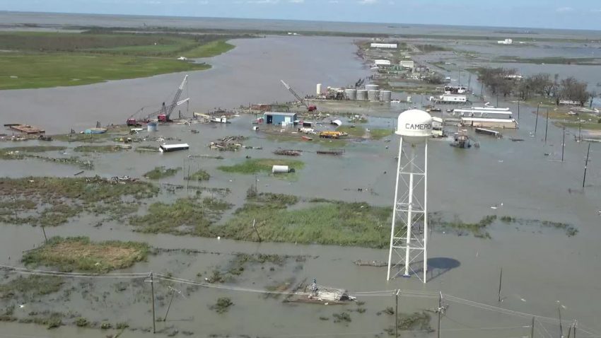
As of now, 6 deaths have been directly linked to Laura. Laura’s legacy will most likely be filled with images of the extensive wind damage, but a substantial storm surge of over 9 ft (2.7 m) was observed at the coastline. This has left many coastal towns such as Cameron inundated. Besides levelling homes, the surge has led to drinking water for over 220,000 people becoming contaminated.
Video shows the potential chemical plant fire in Lake Charles. Evacuating during a hurricane isn’t just about staying safe from storm surge. It’s also about what can happen in the aftermath in the heart of petrochemical country pic.twitter.com/sSfddsqDyI
— Brian Kahn (@blkahn) August 27, 2020
Many residents are saying Laura is worse than Hurricane Rita of 2005, the previous benchmark storm for the region. All and all, it is very likely the name Laura will be retired from the list of hurricane names of the future.
‼️NEW VIDEO‼️
Hurricane #Laura‘s eye went right over Cameron, #Louisiana overnight Wednesday into Thursday and pummeled the area. Many homes & businesses were flattened by hurricane force winds & storm surge. Surge flooding is still ongoing! #lawx pic.twitter.com/KCgA1x32kv— WeatherNation (@WeatherNation) August 27, 2020