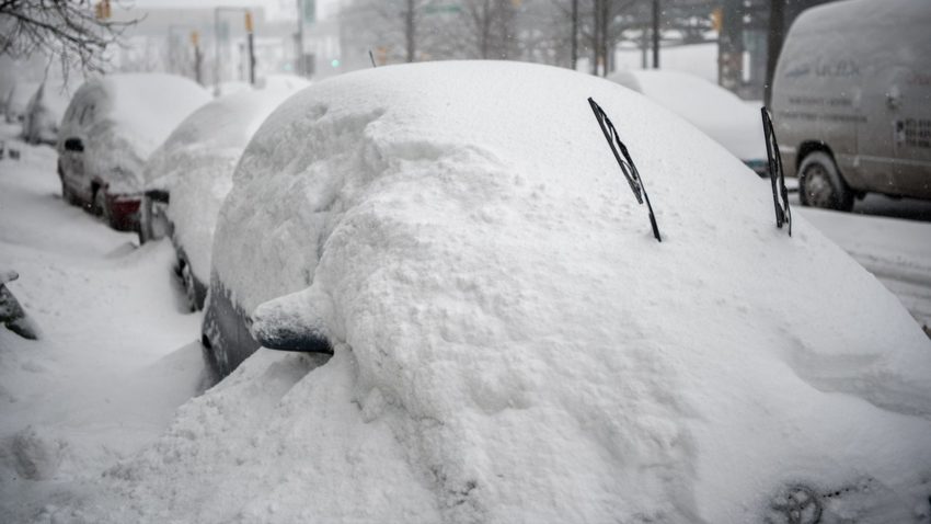
Busy Western Pacific Pattern with Multiple Typhoons Battering Korean Peninsula


An especially active period of typhoon activity continues over the Western Pacific. South and North Korea will continue to be the main focal point for the worst impacts. These storms are coming on the heels of devastating monsoonal flooding earlier in August that claimed dozens of lives. Typhoon Bavi struck North Korea last week, followed by Maysak just today in South Korea. The third and strongest typhoon, Haishen, looks to strike nearly the same region by this weekend.


Bavi reach Category Three status as it moved through the Yellow Sea last week. Fortunately it weakened just before landfall over north Pyongan Province on Thursday, 27-Aug. Minor damage was reported in China, South Korea and some of the southern Japanese islands. More serious impacts, including flash flooding as well as downed trees and powerlines, occurred near landfall in North Korea. Maysak peaked at Category Four intensity on Tuesday over the East China Sea. It was around this time that a livestock-carrying ship, the Gulf Livestock 1, was struck and feared lost with 43 crew and nearly 6,000 head of cattle. Like Bavi, Maysak weakened considerably before landfall but still caused wind damage and power outages for 200,000 households in south and east South Korea.


Typhoon Haishen is currently a Category One with maximum sustained winds to 85 knots (155 kph). However, rapid intensification is expected the next few days as the typhoon moves slowly west-northwest over very warm waters. Haishen will then accelerate and turn north-northwest towards the southern Japanese Islands (see forecast map above). Another South Korean landfall is expected this weekend, very close to the major port city of Busan. Like the other recent storms, some weakening is expected before landfall. However, the cumulative effect of monsoonal flooding and the recent typhoons has left the region vulnerable. Downed trees and powerlines will occur more readily over a densely populated area, leading to major disruptions.

Hurricane Laura Rakes Through Louisiana!

Hurricane Laura roared ashore around 1:00 am Thursday morning near Cameron, Louisiana. The Category 4 storm contained winds of 150 mph (241 kph) at landfall, making it the strongest storm on record to strike southwestern Louisiana. It is also tied with the Last Island Hurricane of 1856 for strongest storm at landfall to hit the state, and is the fifth strongest hurricane on record to landfall in the continental United States. With a central minimum pressure of 938 mb at the time of landfall, it is the fourth lowest pressure recorded in Louisiana history. Before landfall, Laura’s winds rapidly intensified 65 mph (105 kph) in 24 hours, tying the record set by Hurricane Karl in 2010 for fastest intensification rate in the Gulf of Mexico.

Records aside, Laura has absolutely decimated many towns across southwestern Louisiana. Up to 910,000 customers have lost power in the region, as Laura’s winds tore down trees and power lines, ripped off roofs, smashed windows in, and flipped vehicles. Thousands and thousands of homes have either been either heavily damaged, destroyed, or simply levelled. The extreme winds even shredded the Doppler radar dome at the National Weather Service office in Lake Charles, Louisiana.

Lake Charles was particularly hit hard by Laura. Although storm surge flooding did not reach the levels that were predicted, the city was pummelled by destructive winds. Many of the city’s skyscrapers, including the Capital One Tower, had their windows completely blown out. The winds caused a fire to break out at the Biolab chemical plant, leading to chlorine gas being released into the air.

As of now, 6 deaths have been directly linked to Laura. Laura’s legacy will most likely be filled with images of the extensive wind damage, but a substantial storm surge of over 9 ft (2.7 m) was observed at the coastline. This has left many coastal towns such as Cameron inundated. Besides levelling homes, the surge has led to drinking water for over 220,000 people becoming contaminated.

Many residents are saying Laura is worse than Hurricane Rita of 2005, the previous benchmark storm for the region. All and all, it is very likely the name Laura will be retired from the list of hurricane names of the future.

Dangerous Hurricane Laura Bearing Down On Louisiana!

An extremely dangerous Hurricane Laura is currently spinning off the coast of Louisiana, poised to make a destructive landfall along the southwest Louisiana coast early on Thursday morning. Laura, a formidable Category 4 storm is packing winds of 150 mph (241 kph), just 7 mph (11 kph) shy of Category 5 strength. Laura will be the strongest storm ever recorded to make landfall in southwestern Louisiana, and is the strongest hurricane of 2020 thus far. Already a record breaker even before landfall, Laura became the earliest “L” storm ever recorded in the Atlantic Basin, forming on August 20th, surpassing Tropical Storm Luis, which formed on August 29th, 1995.

Laura is on track to bring catastrophic damage in the form of flooding rains, damaging winds, and life threatening storm surge. Storm surge is forecasted to reach up to 20 ft (6 m) in some locations, and may penetrate up to 40 miles (64 km) inland from the coast. The National Weather Service has deemed this an “Unsurvivable” surge.The city of Lake Charles, Louisiana is expecting a particularly hard blow as it is low-lying, and surrounded by several waterways that connect to the Gulf of Mexico.

Widespread power outages are almost certain as wind gusts will be well in excess of 100 mph (161 kph). Laura is likely to retain hurricane status even by the time she reaches Shreveport, Louisiana, which is situated in the northern part of the state. This would be anomalous in itself. Excessive rainfall amounts of up to 18 inches (457 mm) are possible, with rainfall rates between 5-7 inches (127-178 mm) per hour at times. Tornadoes are also possible in locations to the east of Laura’s track.

A trail of destruction has already been left by Laura, as the storm traversed the northern Caribbean Islands over the weekend. Most of the damage was due to potent rainfall amounts, which totalled nearly a foot (3.6 m) in portions of the region. The heavy rain triggered flash-flooding, especially in the Dominican Republic. Besides Louisiana, other states including Texas and Arkansas are expected to feel the wrath of Laura within the next day.

Dual Tropical Threats for the Central Gulf Coast in the Upcoming Week!


Tropical Storm Marco is currently entering the southern Gulf of Mexico through the Yucatan Channel. Meanwhile, Tropical Storm Laura is pouring torrential rain across Puerto Rico with Hispaniola and Cuba next on the docket. Interactions with dry air and land masses could restrict how much intensification either system will achieve. However, there is very warm water ahead. The potential exists for not one but two hurricanes to impact the central Gulf Coast in the early to middle of the upcoming week.


There were major shifts in model guidance with regards to Marco today. Last night it appeared Marco would turn west towards coastal Texas. However, the consensus now is for a north-northwesterly track towards Louisiana. Landfall will occur on Monday, likely in the afternoon or evening. Marco has struggled to maintain persistent, strong storm activity around its core, a necessary prelude to intensification. However, favorably warm water and moderate shear lie ahead over the open Gulf of Mexico. Models suggest Marco will strengthen to minimal hurricane status before landfall and hurricane watches have already been issued.


Tropical Storm Laura is about to hit the Dominican Republic. Interaction with the rugged terrain of Hispaniola and then Cuba in the next few days should disrupt Laura’s circulation and prevent significant intensification. However, Laura will encounter the same favorable conditions over the open Gulf as Marco by early next week. Strengthening is likely and Laura may be a minimal hurricane as it approaches a coastal Louisiana landfall on Wednesday.


Dangerous high winds, storm surge, and flooding rainfall can be expected on Monday and early Tuesday, then again on Wednesday to early Thursday. The dangers posed by Laura would be compounded by infrastructure weakened by Marco’s hazards a few days earlier. Emergency services will be severely strained with not enough recovery time between the storms. Even if the storms are only Category One level, two hurricanes making landfall in the same area within 72 hours of each other would be unprecedented in the U.S. meteorological record. A shift of track for either storm would obviously bring some relief to the target zone, but also bring a wider area of the Gulf Coast into imminent danger. Lead photo courtesy flickr user Mary Madigan.