Bitter Arctic Cold Leads to Deadly Traffic Pile-Up in Dallas-Fort Worth

A historically cold Arctic air mass has become entrenched across much of the central U.S. Among other impacts, the frigid air has helped produce a band of heavy freezing rain from Texas through the Tennessee Valley. The icy conditions contributed to a massive traffic accident in the Dallas-Fort Worth metro area Thursday morning. Over 100 vehicles were smashed in the incident, which claimed the lives of at least six people and injured dozens more.
Road conditions in Texas are bad and they are going to continue to get worse. Please drive safe, y’all. This happened this morning in the Dallas/Forth Worth area. Brake early and drive with precaution. pic.twitter.com/y1BL9sWNVf
— rug∆m∆s (@Rugvmvs) February 11, 2021
The camera just panned over the wreckage in I-35W in Fort Worth and it is jaw-dropping | https://t.co/IV8re79ilk via @wfaa pic.twitter.com/YrrW4dgCGi
— Evan Schreiber (@SchreiberEvan) February 11, 2021
A chunk of bitterly cold high pressure has become dislodged from the Arctic and is funneling down into the central states. This pattern will persist well into next week. The Arctic frontal boundary will even surge as far south as the Gulf Coast. Pieces of upper level energy will ride along this boundary, throwing moisture back into the frigid air mass, leading to periods of heavy snow and ice. One such icy blast affected the region Wednesday into early Thursday, leaving a slick sheet of accumulation on roadways. The ice proved too much for early morning commuters in the Dallas-Fort Worth metro to manage. More than 130 vehicles, including emergency vehicles and tractor trailers, collided into a tangled mass of twisted metal and glass. Six fatalities have been reported with this incident while several dozen more victims were transported to area hospitals.
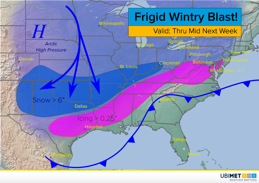
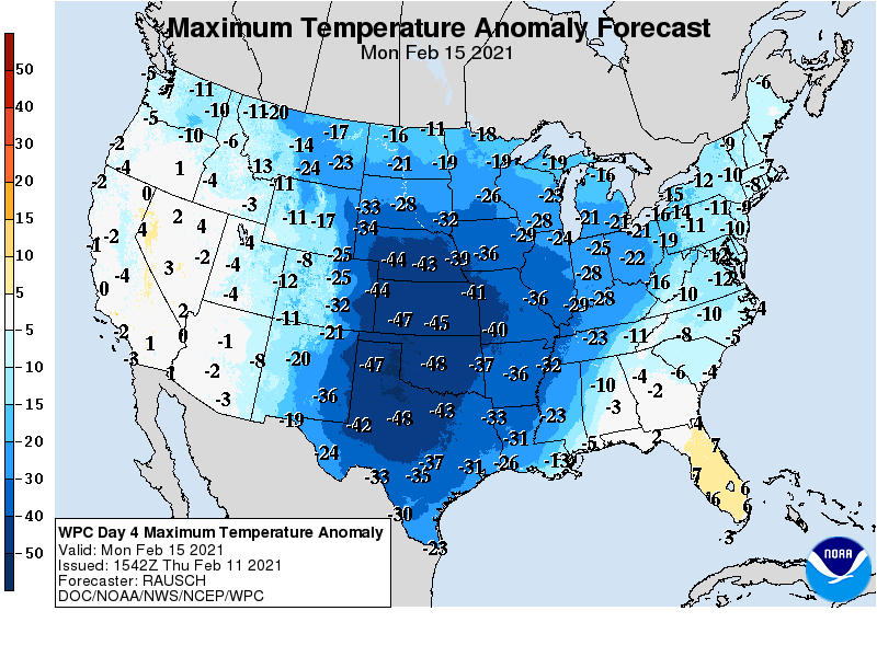
More treacherous conditions will threaten the southern states in the next several days. Locations as far south as coastal Texas and Louisiana will see a wintry mix of icy precipitation. Cities just to the north like Oklahoma City, Little Rock, and Memphis will see heavy snow accumulations up to a foot. Temperatures will remain dangerously cold, as much as 50 degrees below normal (see map below). Wind chills as much as 20 to 35 deg below zero will present a major threat of frostbite to anyone required to be outside for any significant length of time.