Wildfires and Deadly Dust Storm Roll Across the American High Plains


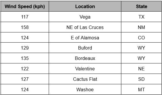
A massive, powerful storm system moved out of the Western U.S. on Tuesday, bringing high winds to the Plains states. Widespread gusts of 55-70 mph (80-110 kph) knocked over trees and powerlines as well as high-profile vehicles (see video below). Higher gusts of 70-100 mph (110-160 kph) were reported at wind prone spots from Montana all the way down to New Mexico (see table below). The high winds picked up dust and created dangerous “brownout” conditions, especially in eastern Colorado and western Kansas. The near-zero visibilities led to a 30-car pileup on Interstate 25 near Pueblo, CO, which killed four and sent 29 more to local hospitals with a variety of injuries.


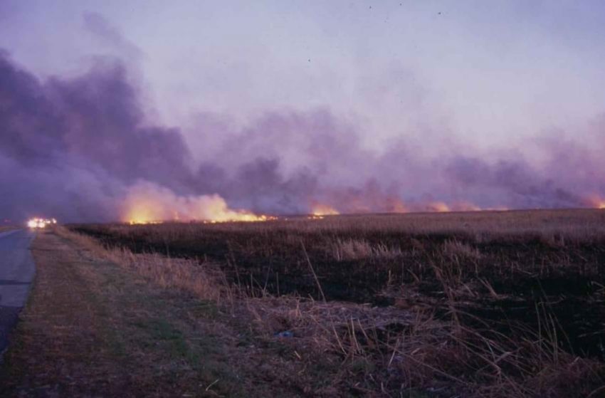
The high winds and dry conditions also pushed wildfires out of control from Texas through Oklahoma and southern Kansas. The largest fire burned 145,000 acres in Beaver County, Oklahoma (see video below). Numerous voluntary evacuations were undertaken. Many homes and buildings were damaged or destroyed, and four firefighters were injured.


Historic Snow Storm Buries Much of North Carolina


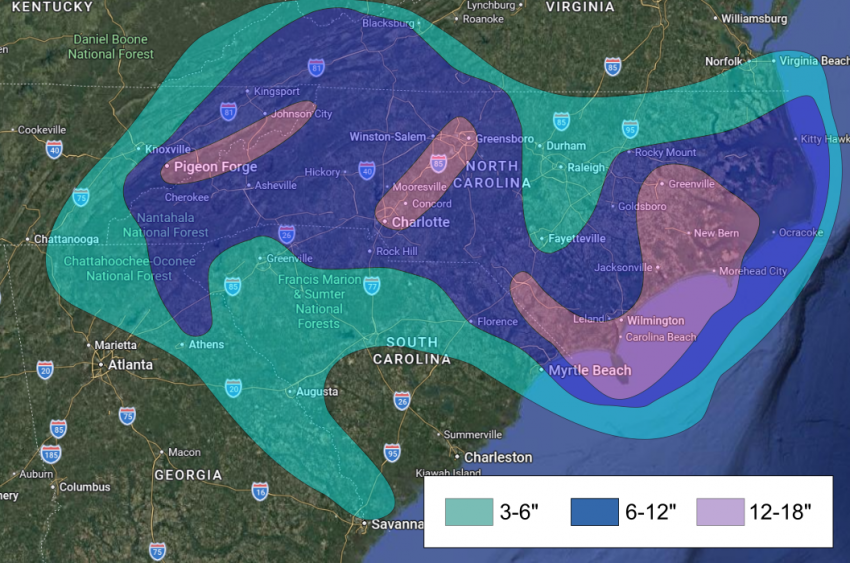
A traffic-snarling snow storm has raked the southeastern USA with near-blizzard conditions along with plummeting temperatures and wind chills below zero. More than a foot of snow has accumulated in some areas, leading to widespread road closures. It’s a crippling event for a region unaccustomed to extreme snows and temperatures.


By far the heaviest snows have fallen across eastern Tennessee and North Carolina. Areas near the Blue Ridge Mountains saw accumulations of 6-12 inches (15-30 cm). Another heavy band dropped accumulations of 10-16 inches (25-40 cm) from the Charlotte metro area up to Greensboro, NC. The near-whiteout conditions led to 100-vehicle pile-up just north of Charlotte (see video above). After several hours the stranded motorists required rescue by the National Guard. A semi-truck became stuck in the snow at a railroad crossing and was slammed by a freight train, though fortunately there were no resulting injuries.


The heaviest snows fell over southeastern North Carolina as the storm exploded just offshore. Totals of 12-19 inches (30-48 cm) were common in this region, the first time the region has seen over a foot of accumulation since 1989. Northerly winds gusting over 50 mph (80 kph) created dangerous blizzard conditions with drifting snow shutting down many roadways. Several communities reported power outages due to the snow and wind, a life-threatening situation given the historic cold temperatures. Hurricane-like storm surge and waves destroyed some beachfront homes on the Outer Banks (see video above). Lead photo courtesy Gail Crouch.

Massive Winter Storm Slams the Southern, Eastern USA


A powerful upper level low spinning out of northern Mexico met a surge of Arctic air to produce dangerous wintry precipitation from the Southern Plains through the Midwest to the Eastern Seaboard. Crippling ice, heavy snow, and even severe storms have occurred with this system. More than a million residences were without power at one time or another. Some of these power outages will linger for several days, a very dangerous scenario with temperatures well below freezing in the forecast. At least 11 deaths are blamed on the storm as of Sunday night.


The northern side of the system featured heavy snow with accumulations of 8-16 inches (20-40 cm) in the mid-Plains and Midwest. As much of 20 inches (50 cm) has fallen in the interior Northeast and southern New England. A zone to the south saw sleet accumulations of 2-5 inches (50-125 mm) and icing over an inch in some spots. The hardest hit area for icing has been from eastern Texas through northern Louisiana and Mississippi to west-central Tennessee. Hours of thundersleet and heavy freezing rain have taken out many if not most branches in some communities, leading to widespread power outages. Power crews working in this area were forced to suspend restoration efforts because large trees branches were breaking off and hitting workers in their bucket lifts. More than 17,000 flights have been cancelled, including all flights in or out of Reagan National in Washington, DC. Sunday was the worst day for flight cancellations since the early part of the pandemic in 2020.


Severe storms were confined to the area near the Gulf Coast in southern Mississippi and Alabama as well as the Florida panhandle. But damaging winds exceeding 70 mph (113 kph) and even a few tornadoes were reported in this region.

Wettest Christmas in Decades Brings Flooding, Mudslides to California


The so-called Pineapple Express, a persistent train of rich tropical moisture, brought days of heavy rainfall to California. The L.A. Basin was hardest hit on Christmas Eve and Christmas Day. Numerous daily rainfall records were broken with two-day totals from three to six inches (150 mm), equivalent to several months worth of normal rainfall. The copious rainfall has resulted in significant flooding along with life-threatening debris slides. A state of emergency has been declared in six counties.


Northern California was hit first early in the week. Serious flooding impacted Redding (see above). The atmospheric river then shift south to Southern California in the last few days. Buildings and cars were buried by mud and rocks in Wrightwood, California (see above). Many residents were forced to evacuate, and a few even had to be rescued by helicopter from their rooftops. A section of Interstate 5 was closed due to high water and stranded vehicles on Thursday in Sun Valley (see below), not far from the Burbank Airport. Burn scars from the massive wildfires on the west side of Los Angeles are particularly dangerous due to increased debris and poor capacity to absorb runoff. This risk has prompted evacuations there.


The heavy precipitation is falling as blinding snow in the southern Sierra Nevadas. Storm total accumulations could approach eight feet. Elsewhere, wind gusts as high as 80-100 mph (130-160 kph) have raked exposed coastal and high elevation sites. The combination of high winds and rain-loosened soils increase the risk of downed trees and powerlines and the resultant prolonged power outages.