Historic Flooding Swamps Brisbane Metro!
A slow-moving tropical low has brought days of torrential rainfall to southeast Queensland, including the Brisbane metro. Indeed, rainfall rates have been increasing today with rates approaching 90 mm/hr in some spots. The result has been the worst flooding in decades with more to come.
Woke up to this! 😢 @abcbrisbane #brisbaneflood pic.twitter.com/Hwrcg1gWkq
— Donald Lutz (@braunerhulk) February 27, 2022
The rain gauge network across southeast QLD has been lighting up with widespread four-day totals of 500-1000 mm. Mt. Glorious has registered the highest total with 1,572 mm, but unfortunately this is far from anomalous. These copious rains have overwhelmed streams and rivers across the region, leading to levels not seen in many years.
Boat destroyed in #BrisbaneFloods at Kangaroo Point. Apparently the person on board was pulled safely from the water by SES a few hundred metres upstream. STAY INSIDE if at all possible – if only to help rescue personnel and essential services travel around more safely. pic.twitter.com/XOAykvWAZa
— Ben Pennings (@BenPennings) February 27, 2022
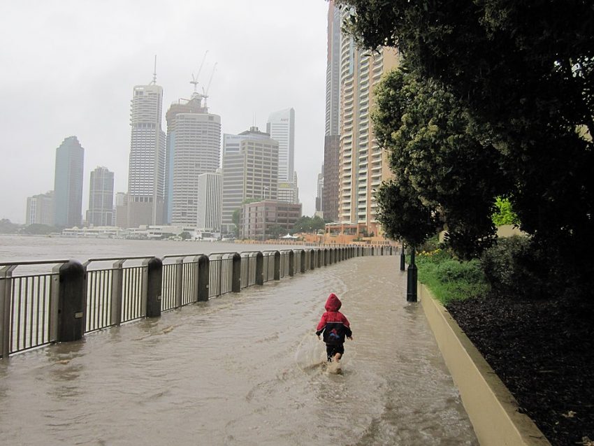
Numerous gauges are reading in the major flood category along the Brisbane River, including downtown Brisbane itself (see tweet videos above and below). Docks, ferry moorings, and even large boats are being destroyed with debris flowing out to sea. Thousands of homes and businesses are under water, prompting widespread evacuations. Roads are inundated across the region and travel has been highly discouraged or prohibited by officials. The city bus service has been stopped entirely for the time being. Forced releases from the Wivenhoe Dam just upstream will only exacerbate the flood crisis in the next 24-48 hours. At least six people have drowned so far in the flooding across the region.
Don’t think I’m going anywhere today…. #brisbanefloods #Brisbane pic.twitter.com/0eA4Iixw2s
— George Eastmead – AcornGames.gg (@GEastmead) February 27, 2022
The low pressure system responsible for the rainfall will slide slowly south of Brisbane later tonight, allowing the rains to ease. A significant flooding threat will follow the low into northeast New South Wales through Monday. Lead photo courtesy Mikeymoocow.