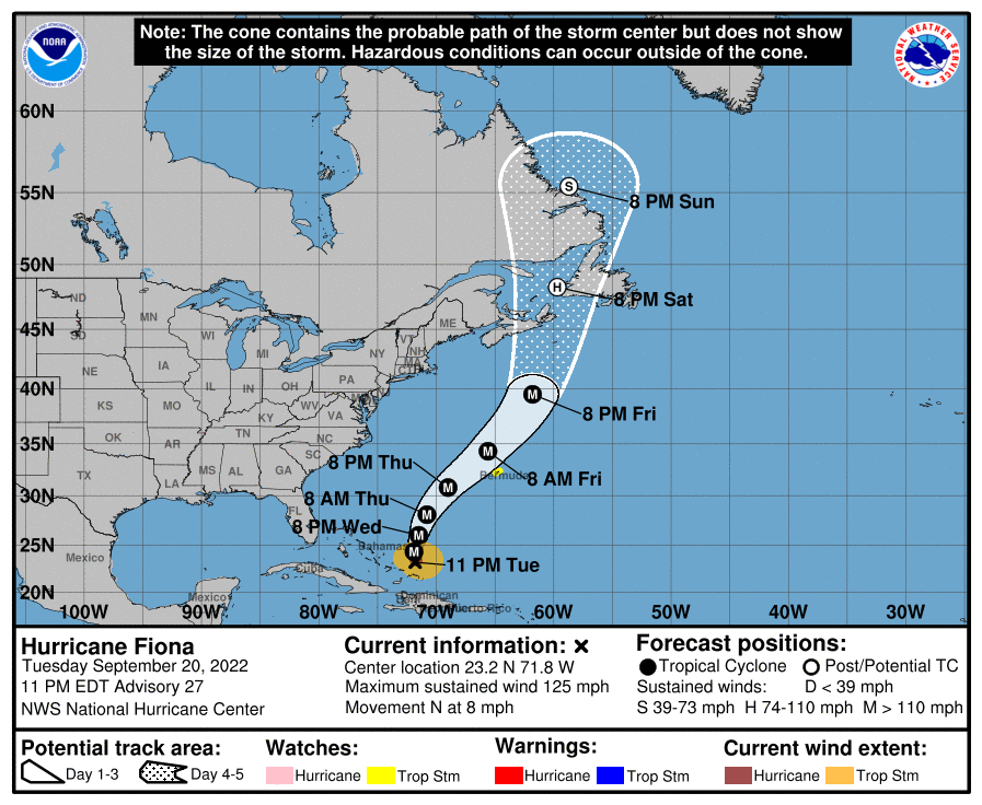
Lake Effect Snow Buries Parts of Upstate New York!
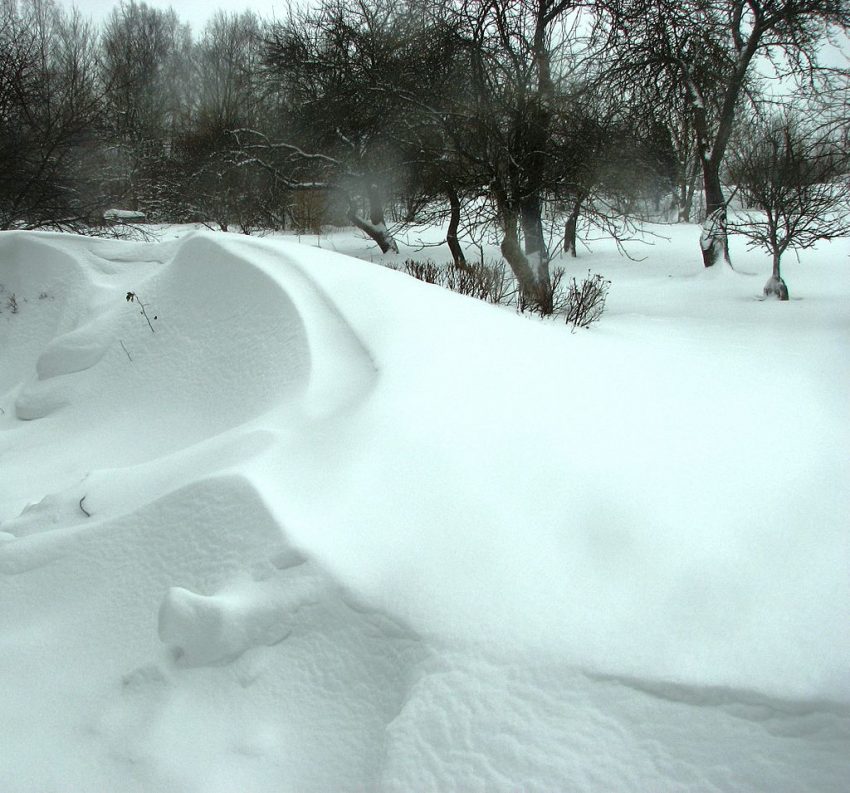
A blinding lake effect snow band has paralyzed communities just south of Buffalo, NY. The band developed on Thursday evening and has been dumping snowfall at rates of 3-5 inches per hour (7-10 cm/hr) ever since. Other than slight wobbles, it has been almost stationary in the past 18-24 hours. The result is accumulations exceeding five feet in some areas with heavy snow still falling (see pictures and videos below).
day one aftermath❄️☃️ #BuffaloNY #BuffaloStorm2022 #buffalosnow #BuffaloBills pic.twitter.com/atuc0Le0IN
— Ship (@ShipStreaming) November 19, 2022
snow mushroom update… #buffalo #buffalosnow #LakeEffectSnow #LetsGoBuffalo pic.twitter.com/PRa4LJPKH8
— MaryAnn (@n1temare74) November 18, 2022
Lake effect snow occurs when very cold air passes over a relatively warm body of water. The band picks up moisture from the lake surface and deposits it onshore in the form of heavy snow. It tends to be very localized but is highly unstable, even to the point of producing lightning (see satellite imagery below). As long as the wind direction remains constant, the band is stationary, meaning the same locations receive prodigious snow totals. In this case, persistent westerly winds passing over Lake Erie are yielding a stubborn band of snow just south of Buffalo. Amazingly, locations just north or south of the band have received only a few inches (<10 cm). The video below shows how sharp the delineation is at the edge of the snow band.
This is an even nicer one recorded just a few minutes ago.
Buffalo NY 11/18/2022 #LakeEffectSnow @TheBuffaloNews @NWSBUFFALO @nytimes pic.twitter.com/EuWTkJADyh— WAlves (@w_wdglma) November 18, 2022
Wow. Seven hours of off-and-on lightning in Buffalo.
One of the most prolific thundersnow events I’ve ever seen. pic.twitter.com/DNgqKCtJ24
— Dakota Smith (@weatherdak) November 18, 2022
Models suggest the current snow band will weaken overnight into early Saturday. However, severe disruptions will persist well beyond. Both college and professional football teams in the Buffalo area have cancelled or relocated their games this weekend (see video below showing the current state of the Buffalo Bills stadium). Roads are closed and a state of emergency has been declared in the affected region. Lead photo courtesy Ave Maria Moistlik.
SO MUCH SNOW. 🥶🥶#GoBills | #BillsMafia pic.twitter.com/ThwcANSfaT
— Buffalo Bills (@BuffaloBills) November 18, 2022