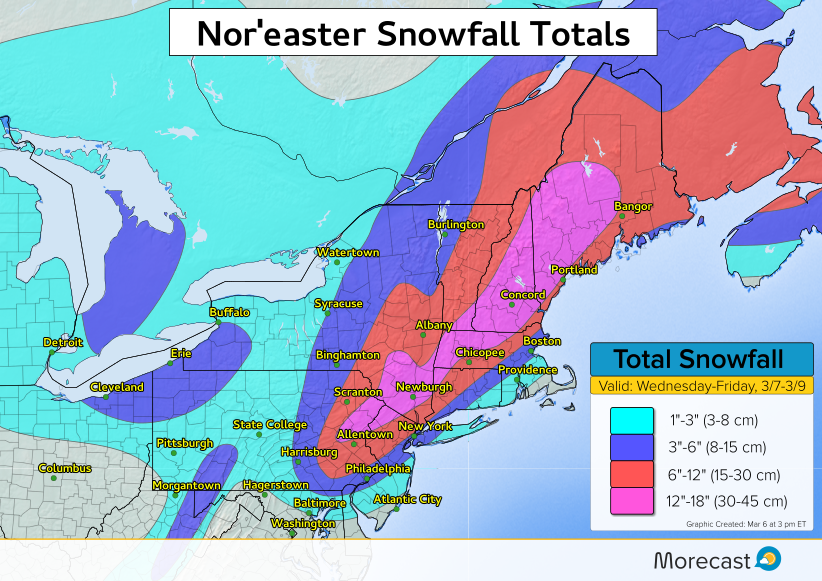
Nor’easter Pummels Northeast with Snow, Rain, Wind

A quickly strengthening nor’easter will move up the Northeast coast bringing heavy snow, wind, and rain Wednesday and Thursday.
The Details:
The heavily populated I-95 corridor from Philadelphia to New York and close to Boston will see accumulating snow, though amounts will vary greatly. The potential exists for 6-12 inches of snow, especially if a heavier snow band sets up. Travel will be difficult to nearly impossible at times within the areas of heaviest snow. Air travel will also be impacted, with numerous cancelled flights already in the Northeast Wednesday afternoon.
As #LGA experiences increased cancellations, all activity at Terminal A has concluded for the day, including all @jetblue @alaskaair. Terminals B, C & D continue to have scheduled arrivals & departures. Please contact your airline to check flight status or to rebook your flight.
— LaGuardia Airport (@LGAairport) March 7, 2018
Strong winds will batter coastal locations and bring the second risk for moderate coastal flooding in less than a week. Where the stronger winds are combined with snow, visibility will be reduced to near zero at times.
The combination of heavy wet snow and strong winds will lead to downed trees and scattered power outages.
The storm will lift into central and northern New England on Thursday with significant snow and strong winds expected.
In the wake of the nor’easter, seasonably chilly air with scattered snow showers will continue on Friday as broad northwest flow keeps the colder and unsettled weather pattern in place.