Near-Normal Weather Ahead Thanks to Neutral ENSO


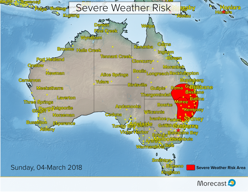
Rivers in northeastern Queensland are only now starting to recede from major flood levels due to torrential rain earlier this week. Many stations reported more than 500 mm in the space of four days, on the heels of one or more heavy rain episodes earlier this month. Fortunately, the forecast looks promising for drier conditions as we head into the autumn.


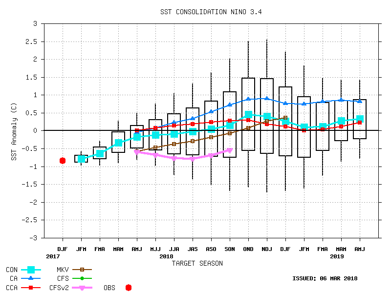
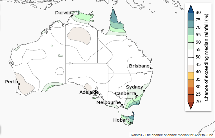
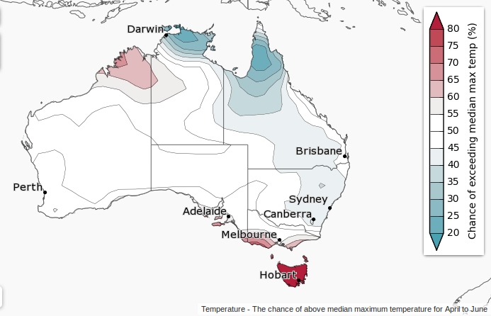
Currently, the El Nino-Southern Oscillation (ENSO), a pattern of Pacific sea-surface temperatures that has significant effects on worldwide weather, is in the negative phase. Otherwise known as La Nina, this pattern typically results in wetter-than-normal conditions, especially over the northern third of the country. The forecast for ENSO in the next month is for the index to transition from La Nina towards neutral (see graph above). The maps below show the likely result, near-normal precipitation across much of the country. The exception may be the far northern tropics and the far southeast, including Tasmania. Near to just above normal temperatures can also be expected for portions of the northwest and southeast, with cool temps over the northeast. The graphics below are provided by Australia’s Bureau of Meteorology.


Another Potential New England Snowstorm This Week!

We’re watching another potential Nor’Easter this week as the active pattern continues. The trajectory for this system could bring the heaviest snows to coastal New England. However, it’s still to early to rule out major impacts along the entire Urban Corridor.


The storm in question will emerge from the Southeast and Mid-Atlantic, where some significant snow could fall in the mountains. Later Monday, snow will expand into the Northeast, diminishing by Wednesday in Maritime Canada. As of now, we’re expecting the heaviest snows, likely exceeding six inches with totals upwards of a foot, from much of New England across New Brunswick. Lighter snows will affect New York City and Philadelphia. Winds will increase along coastal New England on Tuesday, gusting up to 50 mph.

As with any snow storm this time of year, surface temperatures and exact storm track will make major differences in snow accumulations. We’ll be able to give more detailed snow forecasts by Sunday.

Still Time to Ski and Board!

It’s March, but it’s not too late for skiers and boarders to hit the slopes!

Here’s a look at this season’s snowfall amounts across the continental U.S. (The yellow dots show all of the ski resorts across the country!) All states in the Lower 48 have seen some snow this season!


The Northeast is recovering from back-to-back Nor’easters that provided several feet of late season snow. Check out this map showing the departure from normal snowpack across the U.S. This recent winter blast holds much of the Northeast in above average snowpack (blues) through the first part of March.

Besides the Northeast, the northern tier of the U.S. and the Cascades are also hanging onto higher than average snowpack. On the flipside, the Central Rockies have suffered in terms of snowfall this year, with Colorado only receiving about 70% of their average seasonal snowfall. Unfortunately for their ski resorts, less than average snowpack (yellows and reds) are shown on this map.

There’s still plenty of snow out there skiers and boarders-get out and have some fun!


Severe Storms Threaten NSW and QLD Sunday

The weekend will start out quiet across much of eastern Australia, however, a cool change moving northward on Sunday will bring a risk for severe storms to NSW and QLD.

The greatest risk for severe weather will develop from east-central NSW northward into southeast QLD on Sunday afternoon and evening. This threat would include cities such as Newcastle, Coffs Harbour, and Toowoomba.

As temperatures warm Sunday morning and midday, the atmosphere will become increasingly unstable. As the cool change moves northward and clashes with the instability, thunderstorms will erupt.

Frequent lightning will be the most dangerous hazard with these storms, although damaging winds and large hail could also accompany the stronger storms.

Heavy falls of rain in a brief period of time may also lead to localised flash flooding.

Below is the first look at Morecast’s severe thunderstorm outlook for Sunday.