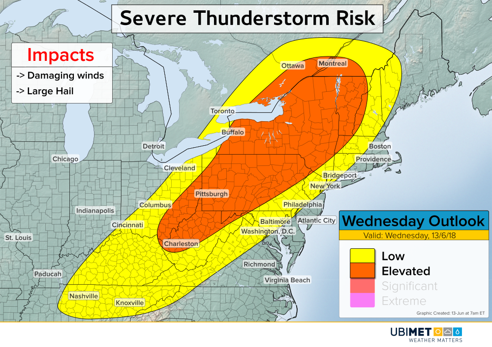
Severe Thunderstorms Target Ohio Valley and Northeast

Scattered severe thunderstorms are expected to develop Wednesday afternoon and evening from the Ohio Valley into the Northeast. Damaging winds and large hail will be the main risks associated with storms.

Severe Weather Details

A cold front will move across the Great Lakes and into the Northeast Wednesday afternoon setting the stage for some severe weather.

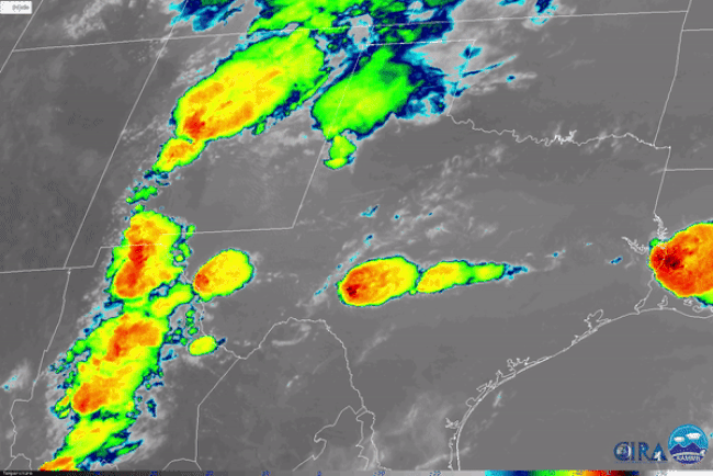
Clusters of showers and thunderstorms are expected to develop along and ahead of the front Wednesday morning and midday. As the environment becomes increasingly unstable, some of the thunderstorms will acquire severe characteristics. Damaging wind and large hail will be the primary threats from any severe thunderstorm Wednesday afternoon and evening.

Cities facing the greatest potential for a severe thunderstorm include Charleston, Pittsburgh, Albany, and Montreal.

As the cold front heads toward the Northeast coast Wednesday night, it will encounter a more stable air mass. Consequently, the risk for severe weather in the major Northeast cities from Washington to Boston will be low to non-existent.

Hurricane Bud Heading Toward Mexico; Weakening Expected

Hurricane Bud will track toward the Baja California Peninsula of Mexico this week. Bud is expected to weaken before making landfall on Thursday, however, rain, wind, and storm surge impacts are still anticipated.

The Details on Bud

Bud strengthened into a major hurricane on Monday as the cyclone churned through an environment favorable for tropical disturbances. Satellite imagery from Monday showed deep convection wrapped around a well defined eye.

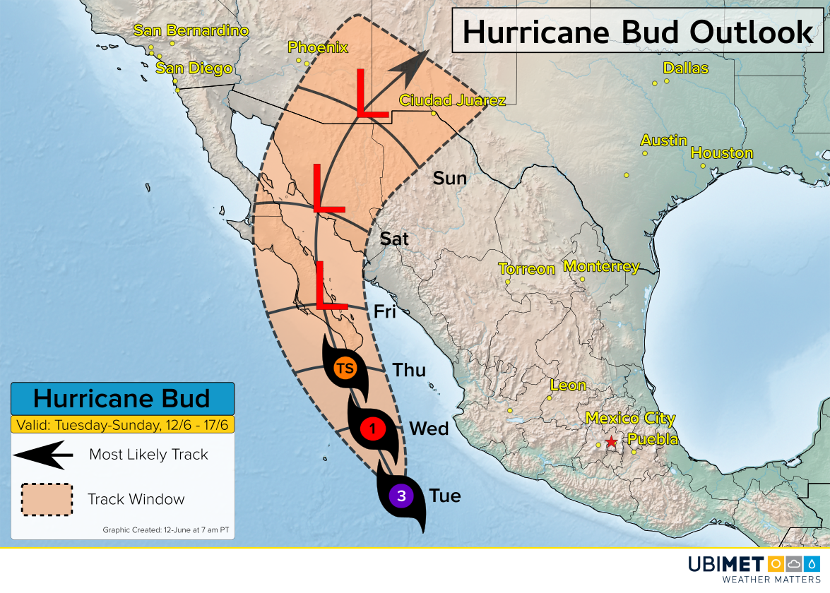
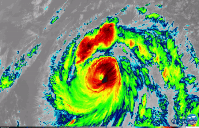
Bud is the second earliest second major hurricane (category 3 or higher) on record. Last Friday, the first named storm of the East Pacific hurricane season, Aletta, also achieved major hurricane status.

As Bud moves into cooler waters later Tuesday and Wednesday, weakening is expected. Landfall is expected during the day Thursday near the resort town of Cabo San Lucas.

Despite the expected weakening, heavy rain, wind, and a storm surge is expected across Mexico’s southern Baja Peninsula as early as Wednesday night and continuing through Thursday and into Friday. Flooding will be the primary concern as 4-8 inches (100-200 mm) of rain falls within a 24-36 hour period.

Once Bud degenerates into a tropical low, moisture from the storm will be drawn northward into the Southwest U.S. by Friday and over the weekend. The additional moisture from Bud will bring increasing chances for showers and thunderstorms to cities like Phoenix, Albuquerque, New Mexico and El Paso, Texas.

“Fire Volcano” Eruption Continues to Impact Guatemala

The Guatemalan volcano known as “Volcán de Fuego” erupted Sunday morning sending rocks, ash, and volcanic gases high into the sky.

The eruption occurred about 25 miles (40 km) from Guatemala’s capital city and was detectable on NASA’s GOES-East satellite.

NASA GOES-East satellite imagery from the visible channel shows a darker plume over the mountain of Volcán de Fuego late Sunday morning. This darker plume represents ash being thrown high into the air from the volcanic eruption.

A satellite loop from the region clearly detects the eruption. Notice that a pink-looking dot becomes visible just prior to the dark ash plume.

Impacts

The village of San Miguel, which sits 6 miles (10 km) from the volcano, was hit especially hard with many buildings damaged or destroyed.

What makes volcanoes particularly dangerous are pyroclastic flows. These dangerous flows are a mix of hot rocks and volcanic gases that flow down a mountain at highway speeds, according to the Global Volcanism Program (GVP). Pyroclastic flow rates of up to 45 mph (20 m/s) have been observed in the past.

Tweets

Take a lot at the next few tweets depicting impacts and footage from the Fire Volcano.

American Airlines Plane Damaged by Hail in Midair

Severe thunderstorms pelted an American Airlines airbus plane en route to Phoenix with hail on Sunday evening causing the flight to divert to El Paso, Texas.

The plane was carrying 130 passengers and 5 crew members.

Thunderstorms erupted across central and western Texas Sunday afternoon and continued into the evening. Ground-based hail reports of up to tennis ball-sized were reported in the vicinity of where the plane was pelted.


Meteorologist Stu Ostro put together some visuals showing the plane’s movement superimposed onto radar imagery. The darker red and purple colors from radar on the top two images are indicative of heavy precipitation, while the white colors on the bottom left image suggest hail was falling.

American Airlines is expected to conduct an inspection on the damaged plane.