Northern Plains Severe Risk

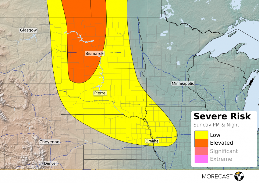
The threat for severe thunderstorms will shift to the Northern Plains this afternoon and evening.

A vigorous disturbance moving across Alberta, Canada on Sunday has drawn moisture and instability northward through the northern Plains helping set the stage for storms to erupt after 1 PM today. Damaging winds and large hail are the primary threats with the stronger storms that develop. Minot and Bismarck, North Dakota are a couple of cities that are at risk for a strong to severe thunderstorm this afternoon into the early evening. Travelers on I-94 through western and central North Dakota should be on guard for potential severe weather.

The severe threat should diminish later this evening in most area; however, a stray stronger storm or two will remain possible across the Dakotas and extend southward to northern Nebraska and western Iowa.

Download the MORECAST app for the latest weather forecast for your location.

2016 Rio Olympics Forecast Update: Gorgeous Weather Still Expected for Opening Week!

The Opening Ceremony for the 2016 Summer Olympics is just a few days away!  Athletes and tourists are gathering in Rio de Janeiro along the south coast of Brazil, where it’s the middle of the winter, but if you’re one of the late stragglers still packing for the trip, don’t bother to pack your parka.  The MORECAST staff still foresees a lovely forecast for the early Games.

Read full article

Saturday’s Storms Bring Another Damaging Hail Threat To Black Hills

A day after severe thunderstorms brought baseball-sized hail to the town of Custer, South Dakota, additional severe thunderstorms capable of large hail are possible around the Black Hills again Saturday afternoon and early evening.

Daytime heating will generate moderate amounts of instability that will aid in the development of isolated to scattered thunderstorms after 3pm this afternoon. A brisk westerly flow 20,000 to 30,000 feet up combined with a light southerly surface wind will generate a moderate amount of wind shear over the north-central High Plains creating an environment that is once again conducive to large hail. Similarly to Friday, the strongest storms will have the potential to produce hail between golf ball and baseball sized.

The threat for storms over the High Plains will diminish after 10 pm, local time.

Farther south, scattered thunderstorms are expected to develop across Kansas this evening and continue into the overnight hours. Locally strong winds are possible within any storm, but widespread severe weather is not anticipated.