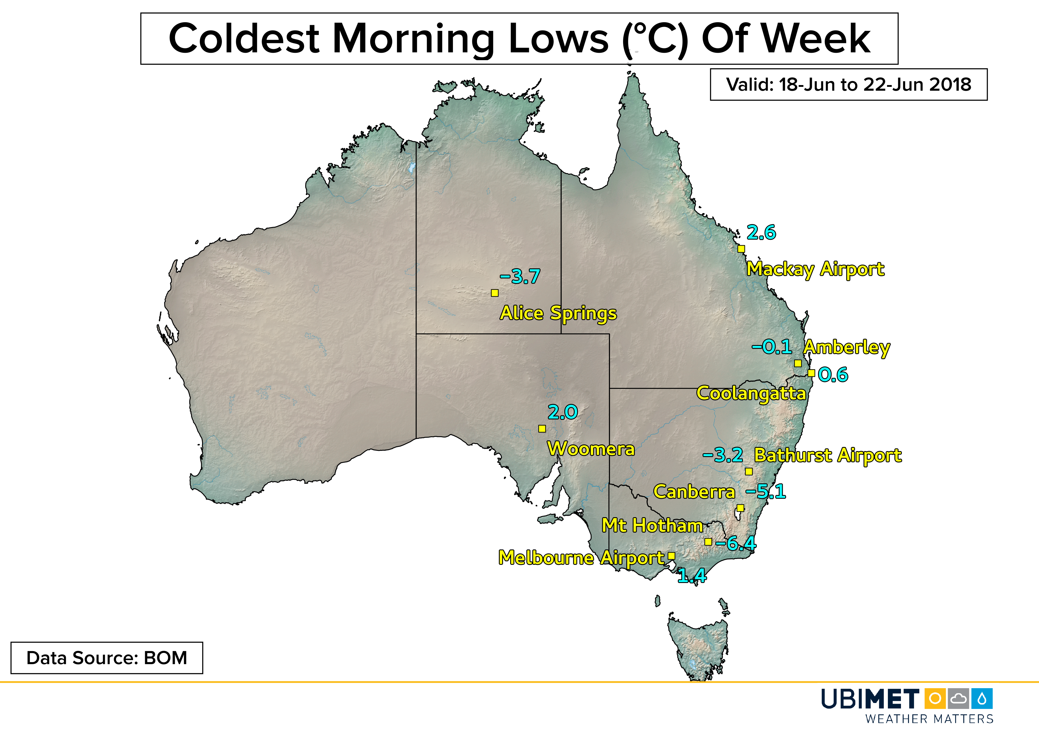
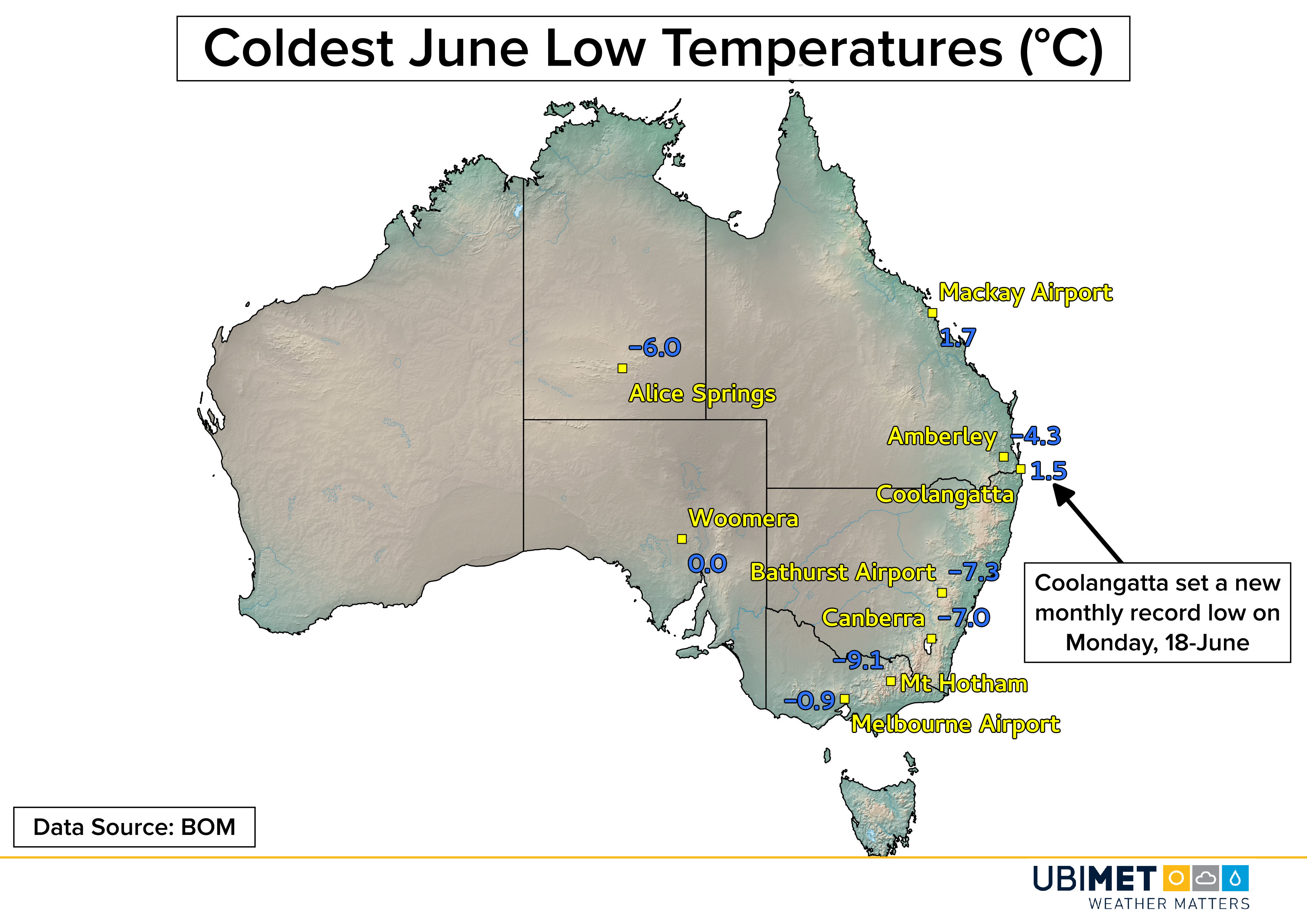
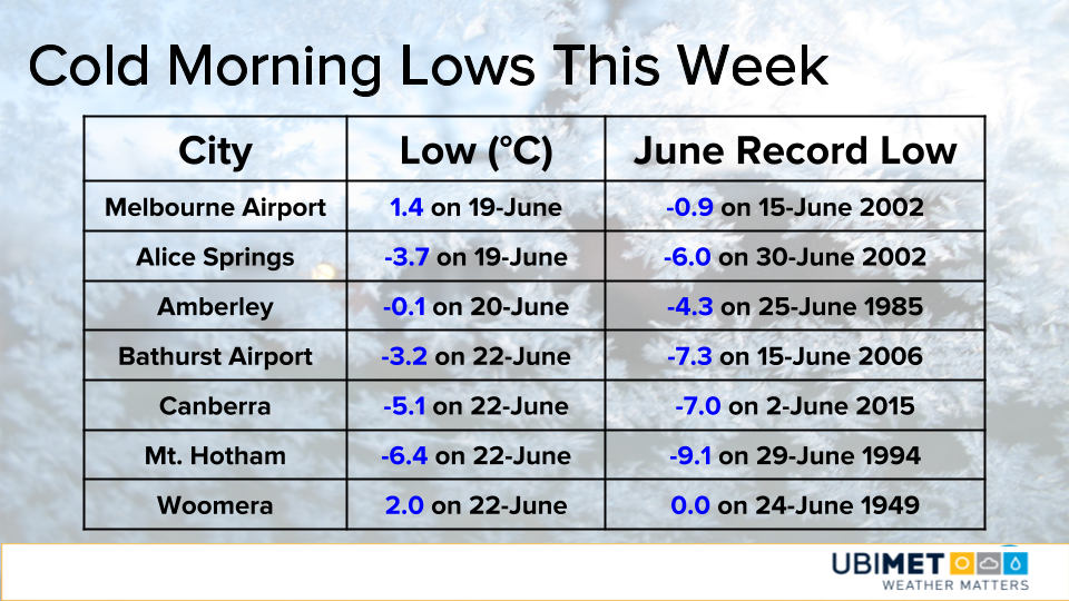
Record-Breaking Heat Targets Great Lakes & Northeast This Weekend

A hot summertime weather pattern will take over much of the eastern US this weekend. Temperatures will soar well into the 90’s (mid 30’s °C) likely leading to several record highs across the Great Lakes and Northeast.

Morecast.com meteorologists have been tracking a building hot weather pattern for the last several days. The primary culprit for the heat will be a hot ridge of high pressure that will shift toward the Northeast. Temperatures across the Great Lakes and Northeast will begin to climb on Friday and max out on Saturday and Sunday.

Saturday:

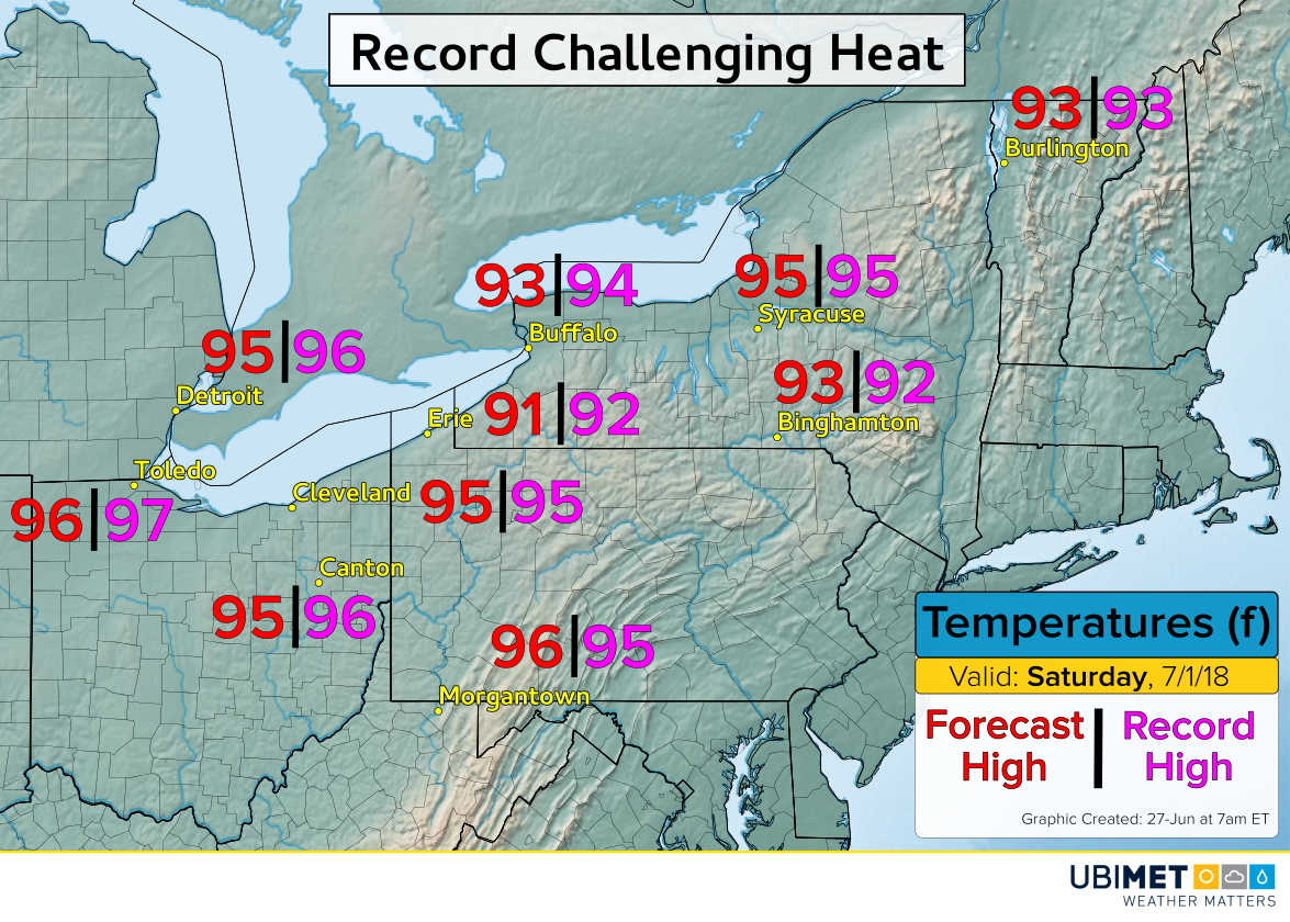
Temperatures on Saturday will climb into the mid 90’s (mid 30’s °C) from Michigan and Ohio up into the lower elevations of New England. Current forecasts suggests that Morgantown, WV and Binghamton, NY are on pace to break record highs, while several other cities will tie or get close to tying record highs.

Along with the hot temperatures will be an increase in humidity. The combination of hot temperatures and increasing humidity will yield head indices of around 100 degrees (38°C) in many communities.

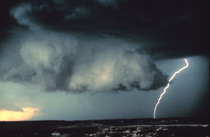
The dome of high pressure overhead will act to keep much of the region dry and stable, consequently, there is little chance for cooling from a thunderstorm.

The stagnant air mass also means that overnight temperatures will remain warm and the humidity sticky.

Sunday:

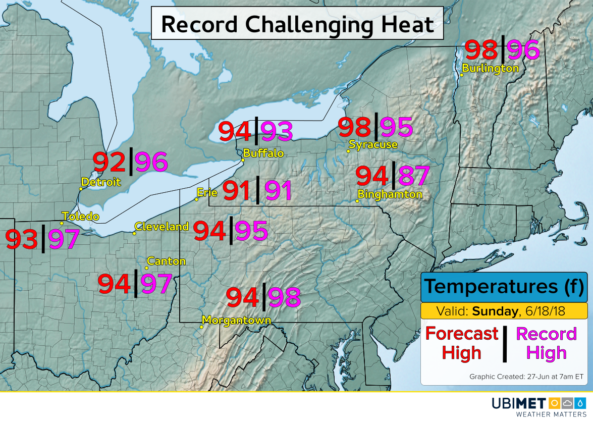
Sunday will be the warmest day of the weekend for many across New York state and New England. Binghamton, NY is on pace to smash its record high of 87 set back in 1968 with a forecast high of 94 degrees. Buffalo, NY, Syracuse, NY, and Burlington, VT also appear on track to set new daily record highs.

Recommended Safety Tips For Hot Weather:

Exposure to hot temperatures can adversely impact health. Consider the following safety tips below from the Center for Disease Control (CDC).

  • Stay in air conditioned buildings as much as possible. Air conditioning is the number one protective factor against heat-related illnesses.
  • Limit outdoor activities, especially during the middle of the day.
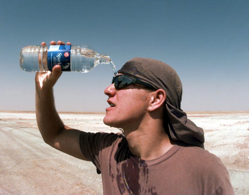
  • Stay hydrated.

Rare Summer Snow Targets Newfoundland, Canada

Snow is the last thing on many minds nearly a week after the summer solstice, however, a rare summertime snowfall is expected to blanket parts of Newfoundland in white into Tuesday.

A cold rain Monday night and Tuesday will mix with and change to a wet, pasty snow at times across central Newfoundland.

Snow accumulation will be highly dependent on where the heavier precipitation rates setup. In areas of heavier precipitation, snow will be the favored precipitation type. Snow accumulations away from the coast could total 10-20 cm.

In areas where more than 5 cm of snow accumulates, downed trees and power lines are possible due to the weight of the snow. Most of the snow accumulation will take place on grassy, non-paved surfaces, however, slushy and snow covered roads are possible at times in heavier bursts of precipitation.

Current data suggests that Newfoundland’s 7th largest city, Gander, could see measurable snow in June for the first time since 2007 when 1.2 cm accumulated. As a reference point, Gander is at a similar latitude and elevation to Paris, France, and Vienna, Austria.

Below are the top 5 snowiest June days on record in Gander. Records date back to 1937.

While June snow in Newfoundland is not unprecedented, it is much more likely to happen during the first half of the month than the latter half.

If measurable snow is observed in Gander, it will mark the 3rd latest snowfall on record.

Stormy Weekend Unfolding across the Plains

Rounds of severe thunderstorms will continue across the Plains this weekend. Damaging wind and hail along with flash flooding is likely, and by late Sunday afternoon a few tornadoes could be embedded in the strongest storms.

Saturday

A cluster of severe thunderstorms erupted across the High Plains of Colorado Saturday afternoon. These storms tracked southeast into Kansas causing scattered reports of large hail and wind damage.

Golf ball to hen egg-sized hail was common from the storms across eastern Colorado. One of the severe thunderstorms was photographed by a twitter user located to the northwest of Lamar, Colorado.

Sunday

A stronger disturbance will move into the Plains on Sunday sparking a greater risk for severe thunderstorm development.

A cold front moving southeastward will ram into a warm and moist flow from the Gulf of Mexico triggering some explosive thunderstorms to develop across western Kansas in the late afternoon hours. Initially, the environment will favor some rotation with the lead storms leading to the potential for a few tornadic cells.

The storms will track eastward and bring a damaging wind, hail, and flashing flooding threat to the central Plains. The heaviest storms have the potential to bring 2-5 inches of rain in just a few hours of time.

The disturbance responsible for the severe weather will be slow to move out early next week, consequently, the risk for severe weather will linger across portions of the Plains into Monday.

Australia Experiences Coldest Week Of Year So Far

The winter solstice arrived in the southern Hemisphere on Thursday, 21-June at 10:07 GMT. For Australia, it was appropriately marked by an unseasonably cold week for many locations.

Earlier in the week, a polar maritime air mass drove northward across the eastern half of Australia all the way to the QLD coast thanks in part to a strong storm spinning between NSW and New Zealand.

The Monday morning low at Coolangatta, Queensland bottomed out at just 0.6°C setting a new monthly record low temperature for June. The temperature was the coldest reading in Coolangatta since 15-August, 2008 when the temperature also fell to 0.6°C. The average June low temperature in Coolangatta is 11.4°C.

Farther north at the Mackay Airport the temperature got down to 2.6°C on Tuesday morning. That was only 0.9°C away from its June record low of 1.7°C set on 2-June, 2000.

Across New South Wales and VIC, many communities away from the immediate coast saw temperatures drop to frosty and freezing levels. In Canberra, the recorded temperature fell as low as -4.7 Friday morning. Surrounding towns were even colder.

Even in the notoriously hot desert region of central Australia the overnight temperatures plunged below 0°C most nights. Alice Springs bottomed out at -3.7°C Tuesday morning. The below freezing temperatures made for some rare wintry-looking photos from the desert.

For some more detailed statistics on the recent cold stretch of weather, check out the table below.

Temperatures this weekend are expected to still tilt below average for most locations in southeast Australia. This is due to a cold front crossing TAS and bringing in a fresh air mass from the south.