Jongdari To Strengthen And Impact Japan As A Typhoon This Weekend

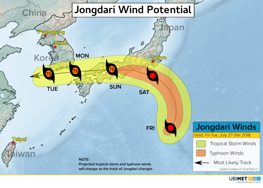
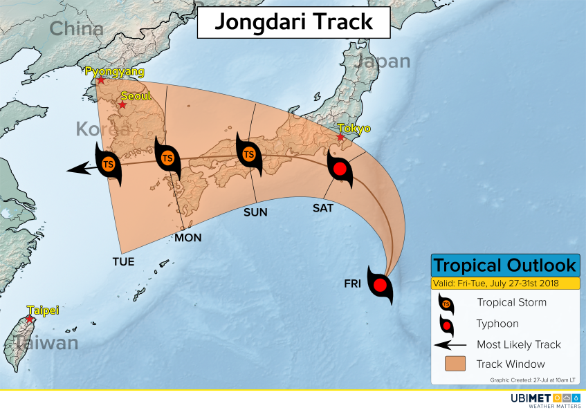
Jongdari is gathering strength across the West Pacific Ocean this week. The cyclone will take a track toward Japan and it is expected to impact the country this weekend.

Environmental conditions such as low wind shear and warm ocean water temperatures of 30-32C will allow Jongdari to become a formidable typhoon by Friday and Saturday.

Steering winds will take Jongdari toward the northeast through Friday, however, a blocking high pressure system over the north-central Pacific Ocean will then force the cyclone toward the northwest and into Japan on Saturday.

Jongdari Impacts

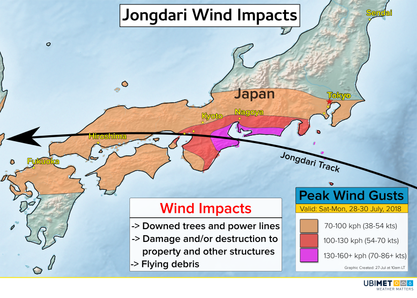
Wind gusts as Jongdari comes ashore will top out in the 130-160 kph range with isolated higher gusts. These speeds will bring down trees, cause power outages, and cause damage and destruction of some property.

The Tokyo metro area will be on the northern fringe of Jongdari’s wind shield. Gusts to around 70 kph will be possible which can still down trees and power lines and cause minor property damage.

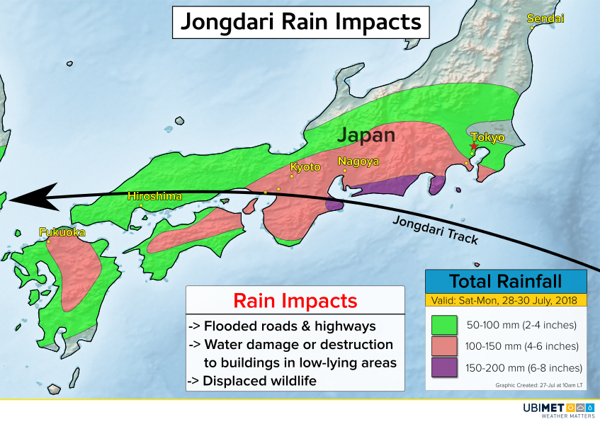
Heavy, tropical rains will accompany Jongdari as the cyclone moves across southern Japan this weekend. Up to 200 mm of rain is expected across communities near the landfall location for Jongdari. Rainfall in the mountains will be locally higher than what is depicted on the rainfall map above.

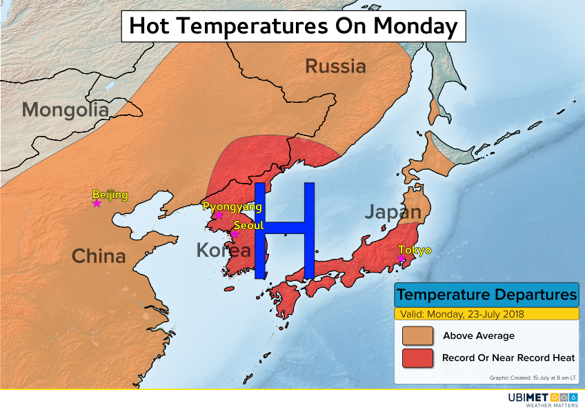
Japan has been in the midst of a record-breaking heat wave that has been responsible for several dozen fatalities as well as disruptions in power. In addition, at the beginning of the month much of southern Japan was inundated with heavy rain that totaled more than 500 mm in a span of just 3 days. The impending impacts from Jongdari this weekend will not come as welcomed news.

Japan City Sets National All-time Record High

July has turned into an excessively hot month this year across much Japan. The city of Kumagaya has set a new national all-time record high according to the Japan Meteorological Agency. Kumagaya sits about 60 km (37 miles) northwest of Tokyo.

Many other daily and monthly temperature records have been challenged or broken over the last week as oppressive heat has controlled the country. Temperature statistics from a few selected cities on Monday are shown below.

In Nogoya, a city with a population of about 2.3 million people, their July temperature record has been broken 3 separate times this month (18/7, 22/7, & 23/7). Records in Nogoya go back to 1946.

The intense heat across Japan is due to a hot dome of high pressure anchored across the Sea of Japan. The position of this high has also brought extreme heat to the Korean Peninsula over the last week.

There is some relief in sight from the high temperatures as the workweek continues.

The hot dome of high pressure over the Sea of Japan will shift westward into eastern China by this weekend. This movement will open the door to more clouds, precipitation chances, and most importantly relief from the extreme heat later this week.

Severe Weather, Tornadoes, Targeted Iowa on Thursday

Supercell thunderstorms erupted across Iowa Thursday afternoon triggering multiple tornado sightings.

One of the strongest thunderstorm cells produced a tornado that ripped through the city of Marshalltown, Iowa.

A second severe thunderstorm produced two tornadoes simultaneously near the town of Altoona, which sits just a few miles northeast of the state capital, Des Moines.

This dangerous storm continued southeast and left behind a trail of damaged and destroyed buildings.

The map below indicates all of the tornado reports that the National Weather Service received from Iowa on Thursday. The several clusters of reports on the map are likely reports from the same tornado producing thunderstorm.

It will likely take several days to confirm the number of tornadoes across Iowa on Thursday, but Ubimet meteorologists estimate that at least 3 or 4 tornadoes will be confirmed.

Funnel Cloud Passes Over NYC On Tuesday

A line of gusty thunderstorms crossed the Northeast on Tuesday and brought heavy rain, strong winds, and a funnel cloud siting in NYC.

Video and photographic content of the funnel cloud started popping up on social media around 3pm ET. Based on social media content and radar data, the funnel cloud likely formed over the New York harbor and then tracked eastward into Brooklyn.

There is no indication that the funnel cloud ever touched the ground over NYC, consequently, no tornado was observed.

The most damaging storms were concentrated across New England. Numerous reports of downed trees and power lines were observed across New Hampshire, Massachusetts, and parts of Connecticut.

In addition to the wind, heavy rain and flash flooding were also observed in some areas of the Mid-Atlantic and Northeast. New York City’s Central Park picked up over 2 inches (50 mm) of rain in 3 hours, while 3-4 inches (75-100 mm) of rain fell along the central New Jersey coast.

The thunderstorms developed along and ahead of a cold front that pushed through the region. A drier and more seasonable air mass will encompass the Northeast for the rest of the week.