Updated 3/9/17 at 4pm EDT
A fast moving winter storm will race through the Northeast Thursday night and Friday, bringing a quick dose of wet snow before bitter cold returns to the region. While not a paralyzing storm for most areas, it will be enough to make for a slippery and slower Friday morning commute for many.
Timing
An area of low pressure will develop along the Pennsylvania-Maryland border Thursday evening. This will lead to areas of light rain to form across portions of eastern Ohio and western Pennsylvania. Rain will begin switching over to snow as colder air is drawn over these areas, spreading eastward overnight across the rest of Pennsylvania, northern New Jersey and the lower Hudson Valley in New York. Southern New England should see flakes starting to fall by sunrise Friday.
The snow will end west to east starting Friday morning, finishing up across southern New England by late Friday afternoon.
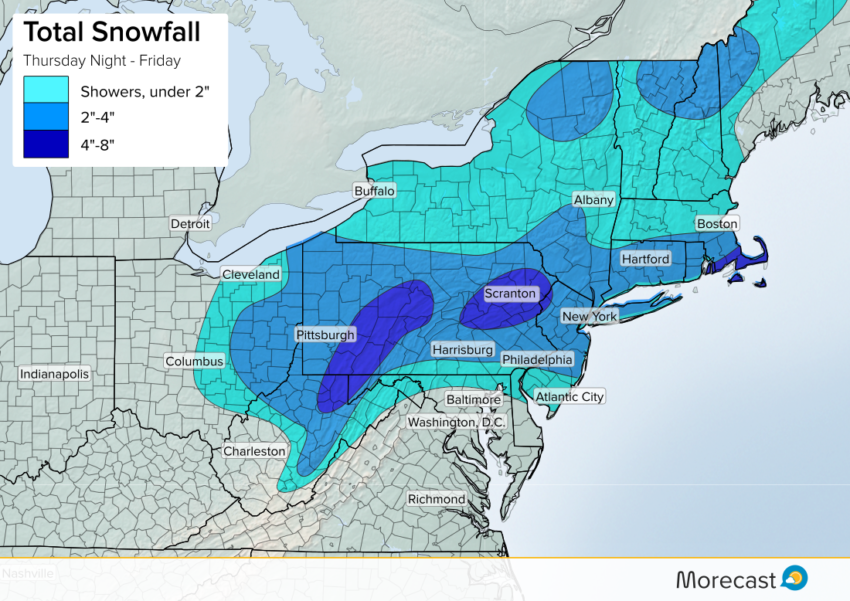
Amounts
The highest snow totals up to eight inches are expected across the Laurel Highlands and Allegheny Mountains in western Pennsylvania, and in the Poconos in northeast parts of the state. The southern coasts of Connecticut, Rhode Island plus the islands of Martha’s Vineyard and Nantucket could also receive a good amount, up to eight inches on the Cape, depending on the storms track and strength once it moves offshore into the Atlantic Ocean. These areas will also have to contend with blowing snow as the winds increase.
A swath of similarly heavy snow through higher altitude areas of PA is anticipated along the I-80 corridor from Youngstown to New York City. At lower elevations, the I-79 corridor from Erie, PA to Morgantown, WV (including Pittsburgh), and the I-95 corridor from Philadelphia to Providence, RI should see two to four inches.
Impacts
Temperatures are likely to hover at or a few degrees above freezing in many places Friday, which will cause some flakes to melt quickly once on the ground. This should keep roads passable, though wet roads and some slushy accumulation could still make things slick for Friday morning’s rush. The storm will also have a good amount of moisture to work with, leading to some heavy bands of snow at times, reducing visibility.
Snow Followed by Cold
Once the snow clears out Friday afternoon, an arctic air mass will pour down out of Canada into the Northeast. Temperatures will plummet down into the teens and 20s across the region by Saturday morning, feeling even colder when factoring in gusty winds up to 25 mph that will accompany the chill. And keep the coats handy, because the cold will last through the weekend across the Northeast, with highs only in the 20s and 30s.