Heavy Thundery Rain Potential For Central Australia

A slow moving disturbance will cross the Northern Territory bringing a heavy thundery rain threat to some normally drier regions in Central Australia.


What cities will be affected?

Cities such as Alice Springs, Tennant Creek, and Camooweal are expected to see rounds of thundery rain starting on Thursday and continuing into Saturday. 3-day rain totals in this area will average 50-100 mm, with some pockets of 100-200 mm of rain likely.

The expected rain falls will lead to a risk for flooding.

Who else will get rain?

Farther to the east, additional rounds of thundery rain across central Queensland will add to the already impressive rain totals so far this March. Communities such as Mount Isa, Cloncurry, and Trepell have seen 100-300 mm of rain since March 1st.

The thundery rain across most of western Queensland will come to an end by Saturday as drier air pushes in from the east. This drier air will bring an end to the thundery rain threat in places like Alice Springs by Sunday.

A third area of heavier thundery rain will exist across the east coast of far northern Queensland from near Townsville to Cairns. The culprit for the rain here is a persistent onshore flow aided by a weak low pressure system over the Coral Sea. The greatest potential for heavy rain will be through Friday, before thundery showers become more sparse over the weekend.


Severe Storms Threaten NSW and QLD Sunday

The weekend will start out quiet across much of eastern Australia, however, a cool change moving northward on Sunday will bring a risk for severe storms to NSW and QLD.

The greatest risk for severe weather will develop from east-central NSW northward into southeast QLD on Sunday afternoon and evening. This threat would include cities such as Newcastle, Coffs Harbour, and Toowoomba.

As temperatures warm Sunday morning and midday, the atmosphere will become increasingly unstable. As the cool change moves northward and clashes with the instability, thunderstorms will erupt.

Frequent lightning will be the most dangerous hazard with these storms, although damaging winds and large hail could also accompany the stronger storms.

Heavy falls of rain in a brief period of time may also lead to localised flash flooding.

Below is the first look at Morecast’s severe thunderstorm outlook for Sunday.

Winter Ends With Record Warmth, Dryness for Southwest & High Plains

Meteorological winter ended this week as February came to a close.

Preliminary data from the Southeast Regional Climate Center shows that across the Southwest U.S. many stations experienced either their warmest or their driest winter on record.

For example, Los Angles International Airport was +2.14 F above average during the December-February period that defines meteorological winter. That value is enough to qualify as the warmest anomaly in the station’s 74 year history. Elsewhere, several other stations in southern California and across the Southwest broke records for winter warmth.

There were no stations in the contiguous U.S. that experienced their coldest winter on record.

Precipitation-wise, record dryness was observed from northeast New Mexico out into central Kansas. It was so dry across portions of southwestern Kansas that Garden City actually went through meteorological winter without recording any measurable precipitation.

To the southeast of the record dryness was a zone of much higher precipitation. Dallas, Texas and areas around Little Rock, Arkansas experienced their wettest winter period on record. Records at these observation station go back 44 years and 42 years, respectively. The stripe of above average precipitation continued northeastward to Pittsburgh, which saw its wettest winter since at least 1948.

Superstorm Sandy: A $70 Billion Storm

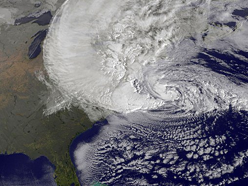
October 29th, 2017 will mark the 5th anniversary of Superstorm Sandy making landfall in southern New Jersey. Sandy had wide reaching impacts to the eastern half of the U.S. 24 states were directly affected in some way.

All totaled, Sandy’s cost to the U.S. is approximately $70 billion. This ranks as the second costliest weather & climate disaster on record. A closer look at the mainland U.S. impacts from Sandy are below.

Storm Surge

The hardest hit areas from Sandy included the New Jersey and New York coastlines. This is largely due to the immense storm surge that piled up against the coast when the Superstorm took its left-handed turn into New Jersey.

The highest recorded storm surge of 12.65 feet occurred at Kings Point, NY which is on the north shore of the Long Island Sound. Further, a storm surge of almost 3 feet or greater was observed in every East Coast state from Florida to Maine.

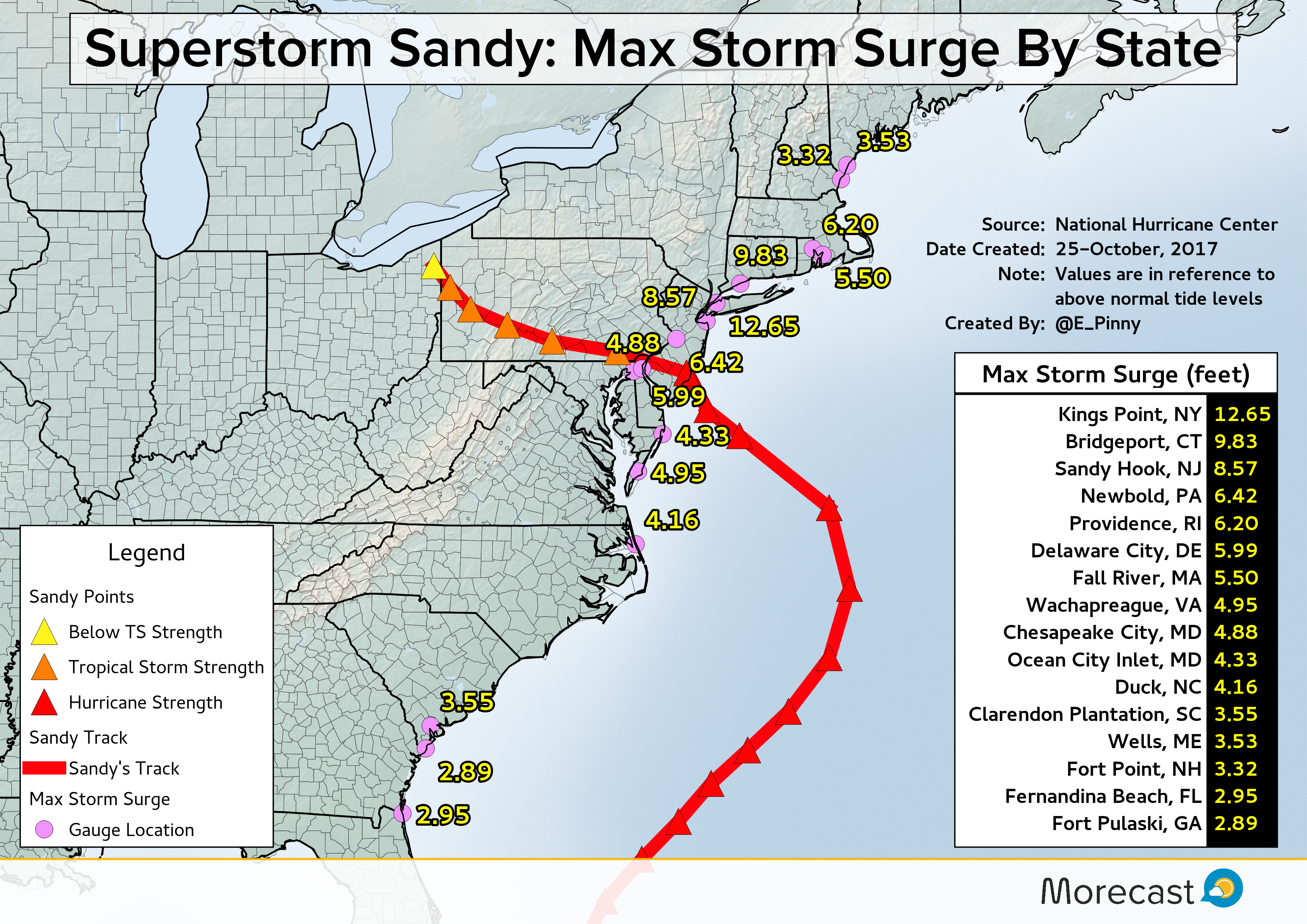
As is typical in many strong tropical cyclones, the storm surge is the biggest contributor to the cost of a storm.

According to the National Hurricane Center’s recap of Sandy, the Metropolitan Transit Authority in NYC reported that 8 subway tunnels were flooded as a result of storm surge. The estimated cost to repair damages to the tunnels is $5 billion. Furthermore, NYC estimates that Sandy will cost the entire city $19 billion mostly because of storm surge damage.
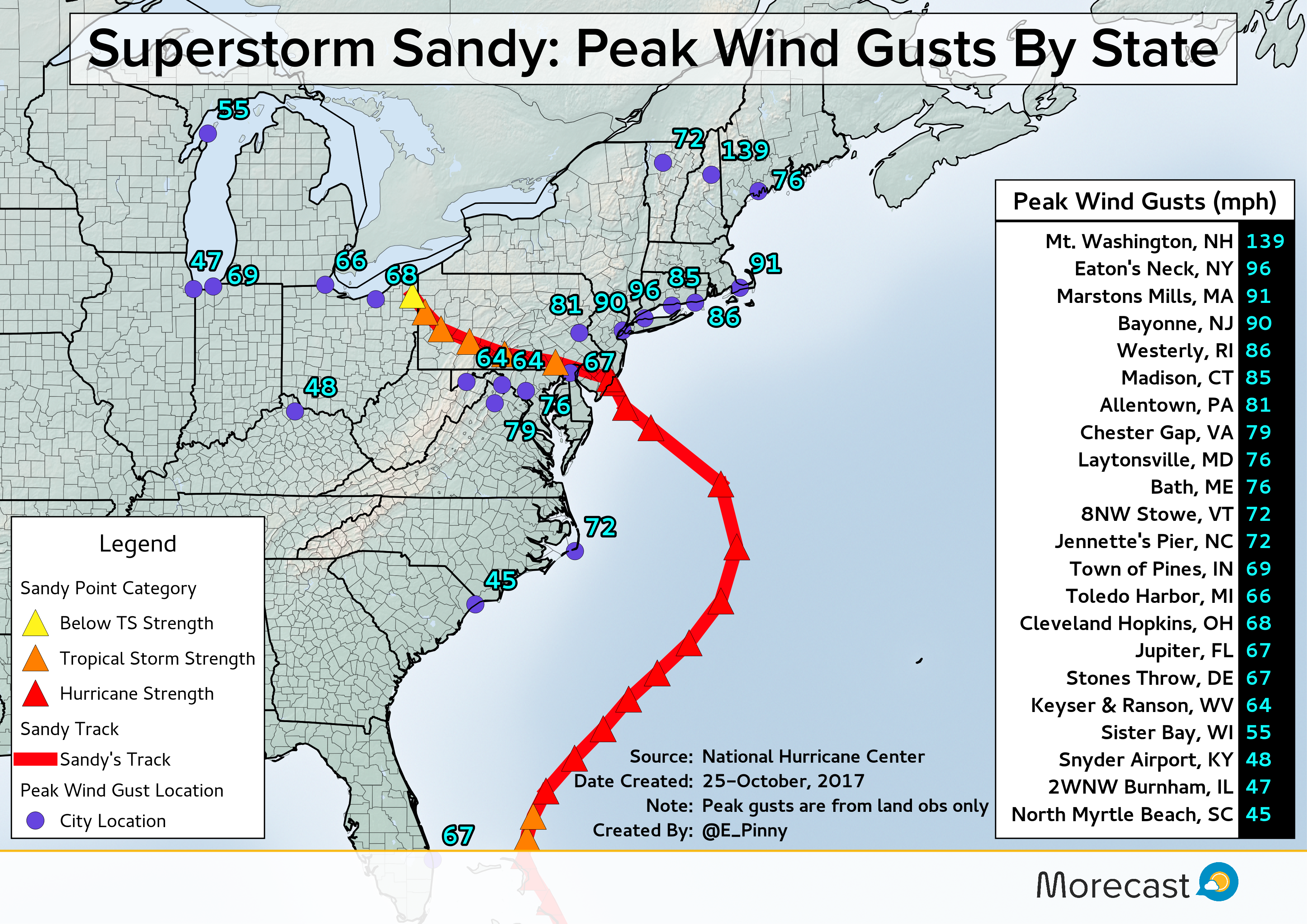
Winds

The most far-reaching impact from Sandy was the storm’s wind field. Before Sandy made landfall in New Jersey, tropical storm force winds reached a diameter of more than 1,000 miles. That is approximately the distance from Washington DC to Jacksonville, FL.

Additionally after Sandy made landfall, tropical storm force wind gusts were observed as far away as Wisconsin and Illinois!

Sandy’s winds were blamed for about 160,000 power outages in Florida, and several million outages farther north across the Mid-Atlantic states.
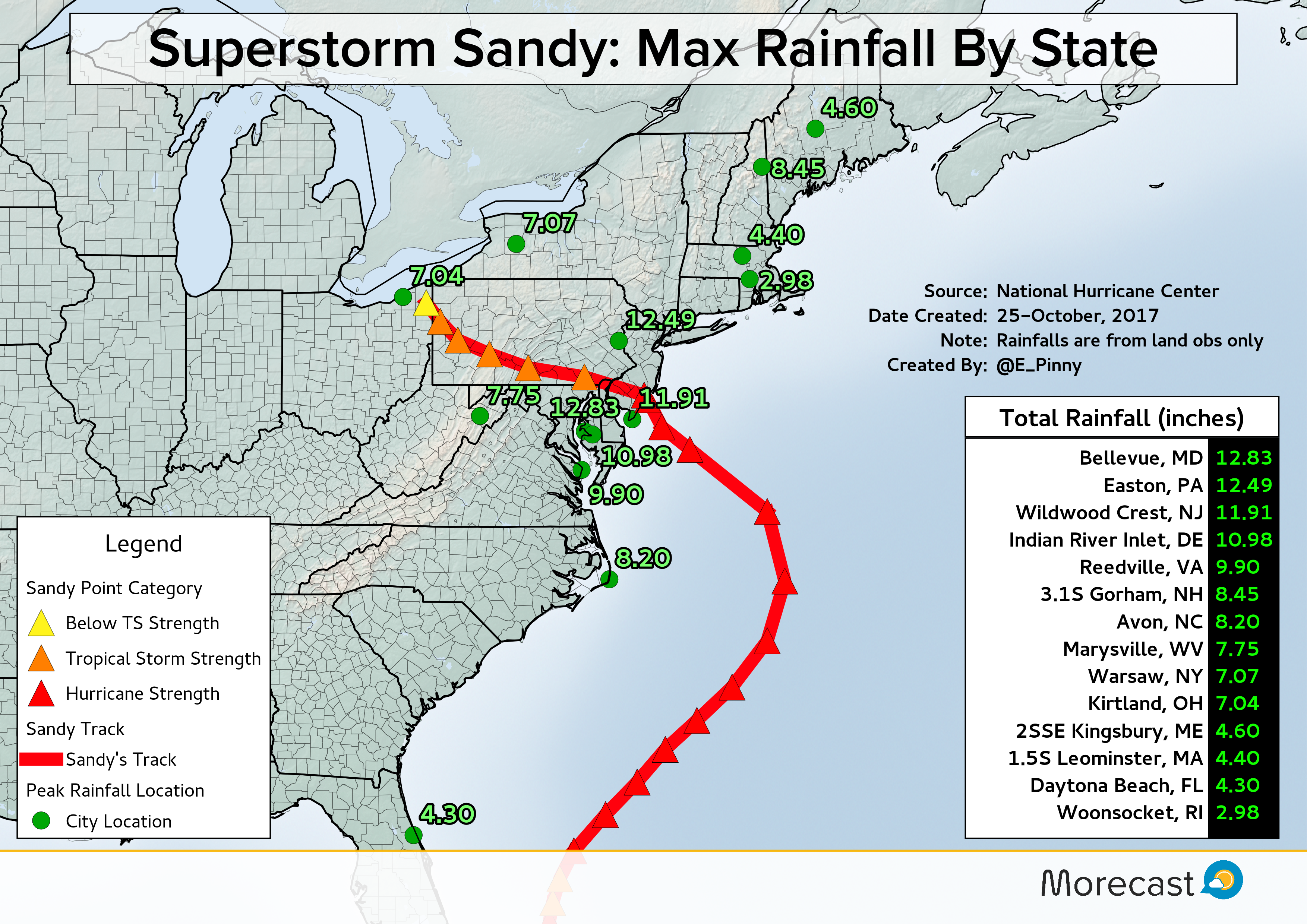
Rain

Once Sandy emerged from eastern Cuba, heavy rain pushed northward through the Bahamas as well as eastern Florida. As the storm underwent a transition from a tropical to non tropical system, the storm grew in size which helped push rain bands inland across the Southeast coast.

As is typical with systems of tropical origins that reach the mid latitudes, the heaviest rain was along and to the left of the storm track. Since Sandy took an unusual left-hand turn into New Jersey, this placed most of the heaviest rainfalls along and to the south of Sandy’s track. The exception was across interior New England where Atlantic moisture was rung out across the higher terrain of Maine, New Hampshire, and Vermont.

The combination of strong winds and flooding from heavy rain caused more than $30 million in damages across Virginia, Maryland, Delaware, and Pennsylvania.
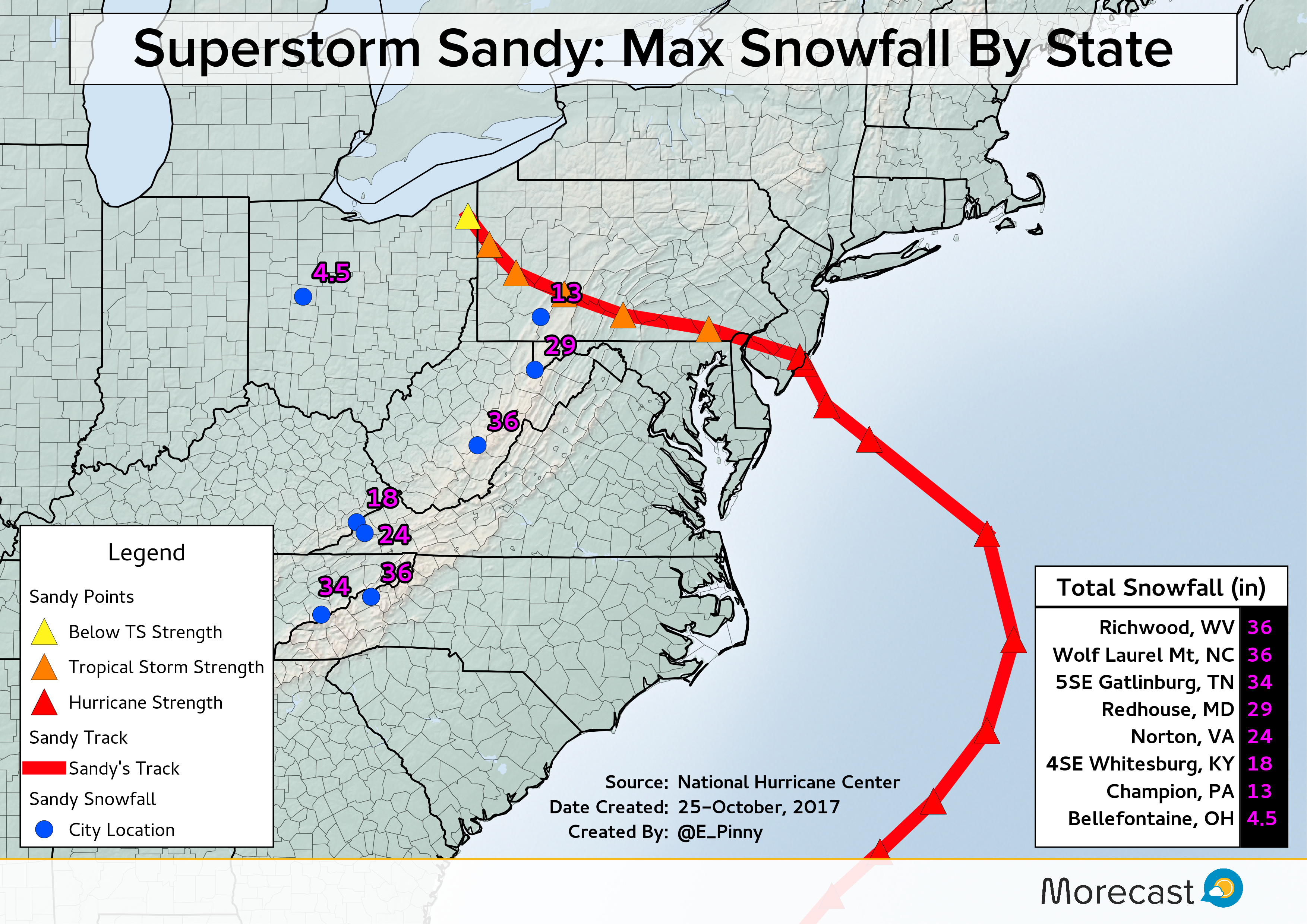
Snow

The icing on the cake for Sandy’s status as a Superstorm was the injection of arctic air from a polar disturbance, which aided in pulling the storm towards the US coast. As precipitation spread westward across the Mid-Atlantic from the coast plain, it fell into an increasingly cold environment changing the rain over to snow across the Appalachians.

One to three feet of snow pasted much of the higher terrain above 2,500 feet from the southern Appalachians northward to southwestern Pennsylvania. The weight of the snow caused a number of structures to collapse as well as thousands to lose power.