Nor’easter #4 Targets East Coast

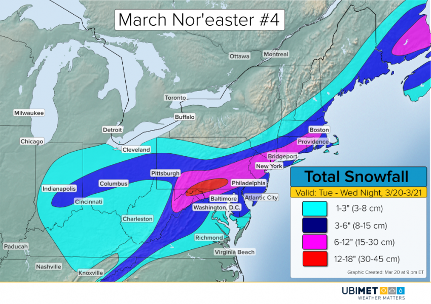
The fourth nor’easter this month will target the Mid-Atlantic and Northeast through Wednesday. Rain, sleet, snow, and wind will accompany the storm from the Ohio Valley to Virginia up to Maine.

Tuesday Recap

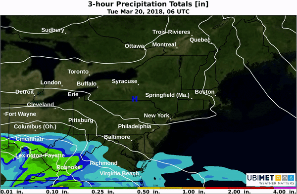
An initial burst of precipitation on during the day Tuesday brought accumulating snow to portions of Virginia, Maryland, and Pennsylvania.

The Maryland Department of Transportation spent Tuesday treating roadways.

Wednesday Forecast

Rain, sleet, and snow will spread across NYC and southern New England by Wednesday morning. As low pressure strengthens off shore, colder air will be drawn into the storm causing the rain-snow line to sink toward the coast. Precipitation will continue, heavy at times, in southern and eastern New England through Wednesday night.

A nor’easter will bring a wintry mix of precipitation to the Northeast Tuesday and Wednesday.

In addition to the precipitation, strong winds and minor to moderate coastal flooding are expected. The combination of snow, sleet, and wind will make for difficult driving conditions on Wednesday from Virginia to eastern New England. Air travel will also be impacted, with numerous delays and cancellations likely.

The nor’easter will move away from the region on Thursday.

Prolonged Thundery Rain Event Setting up for Eastern NSW

A few days of thundery rain are expected across east-central NSW beginning on Tuesday. Falls of greater 100 mm are likely in the areas of heaviest rain, leading to flooding concerns.

The Details

A stiff easterly wind will develop on Tuesday and draw moisture from the Pacific into the area.

Isolated showers and thunderstorms will during the midday hours and then become more widespread later in the afternoon and at night.

Waves of moderate to heavy thundery rain are expected from Tuesday night through Wednesday and into Thursday for some locations. The target for the heaviest rain is expected to be New Castle. It is within this area where widespread 3-day falls of 100 mm or more are possible.

Flash flooding is likely to occur in areas that receive greater than 100 mm of rain. Additionally, mudslides are possible in the hills.

The heaviest of the rain is expected to taper off later Thursday, but additional scattered thundery showers will continue across eastern NSW into Friday.

“Pineapple Express” Event Looming for California, West Coast This Week

The West Coast will be bracing for a prolonged period of heavy precipitation this week from a phenomena known as the “Pineapple Express”. Flooding rain along the coast and hills as well as heavy mountain snow will threaten some communities, especially in California.

Pineapple Express in weather refers to a river of abundant moisture that originates in the tropical Central Pacific and moves up into the west coast of the United States.

What to expect:

Steady precipitation looks to arrive in California on Tuesday and then become heavier and more widespread Wednesday and Thursday. Drier weather will move into southern California on Friday, but unsettled weather will remain farther north.

The mountains of southern California as well as the Sierras look to receive the heaviest precipitation through the end of the week. 4-8 inches (100-200 mm) of rain is possible for elevations between 500-5,000 feet (~150-1,500 meters).

Total precipitation from Tuesday morning through Friday morning.

The major cities along the I-5 corridor will also be susceptible to bouts of heavy rain. Los Angeles looks to take the brunt of the heaviest rain with 2-4 inches expected over a 3-day period.

Flash flooding and mudslides will be a concern, particularly in the hills and across recent burn areas from wildfires.

Across the Sierras above 5,000 feet, 2-4 feet (60-120 cm) of snow is likely to fall. Snow levels across southern California will be closer to 9,000 feet (~2,700 meters), which is above most mountain peaks.

Drought Relief:

Much of California remain in some form of a drought, with severe drought conditions across portions of southern California. The expected rainfall will be good news for the drought relief, despite the flooding risk mentioned above.


Another East Coast Storm Threat Next Week

March has already brought three intense nor’easters to the East Coast, and now a fourth storm may be brewing.

Low pressure will emerge from the Colorado Rockies on Sunday and track into the Tennessee Valley Monday. Beyond Monday, low pressure will redevelop off of the North Carolina coast and threaten the Mid-Atlantic and Northeast.

Along and south of the storm track, an area of rain and thunderstorms will break out. There is a risk for isolated severe weather across the south-central Plains Sunday afternoon. The threat for some gustier thunderstorms will spread across portions of Mississippi, Alabama, and Georgia on Monday afternoon.

Meanwhile, to the north of the low track a cold rain will could mix with snow at times.

2 Scenario Next Week

As low pressure approaches the southern Appalachians on Monday, a second area of low pressure will develop near the North Carolina coast. The location and movement of the second low are crucial to potential impacts across the Mid-Atlantic and Northeast.

The first scenario would feature a storm track to the east-northeast out to sea. In this scenario, a wintry mix of rain and snow could impact interior Virginia. However, much of the Northeast would remain dry.

The second scenario would feature a slightly stronger low pressure system that would take a more northeasterly track. A track closer to the Northeast coast would bring a greater risk of precipitation. Cold air is expected to be in place, so much of the precipitation would likely fall as Snow or a rain/snow mix.

A favored scenario in the track of low pressure is expected to emerge by the end of this weekend.