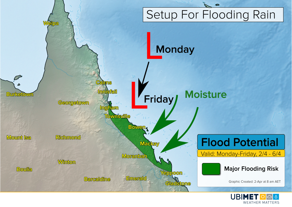
Major Flooding Risk For Central QLD Coast

A slow moving tropical low pressure system over the Coral Sea has strengthen into TC Iris on Monday. Iris will bring rounds of heavy thundery rain to the central QLD coast this week. The precipitation will bring the threat for major flooding from Ingham to Townsville to Mackay.

The Details

Iris will move slowly toward the central QLD coast this week. If the center of the storm stays out over water this week, the Iris could continue to strengthen some this week.

Regardless of strength, a persistent onshore flow will bring an abundance of moisture and numerous rounds of heavy precipitation to the central QLD coast.

Weather setup for significant flooding this week

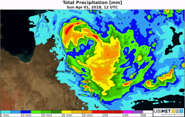
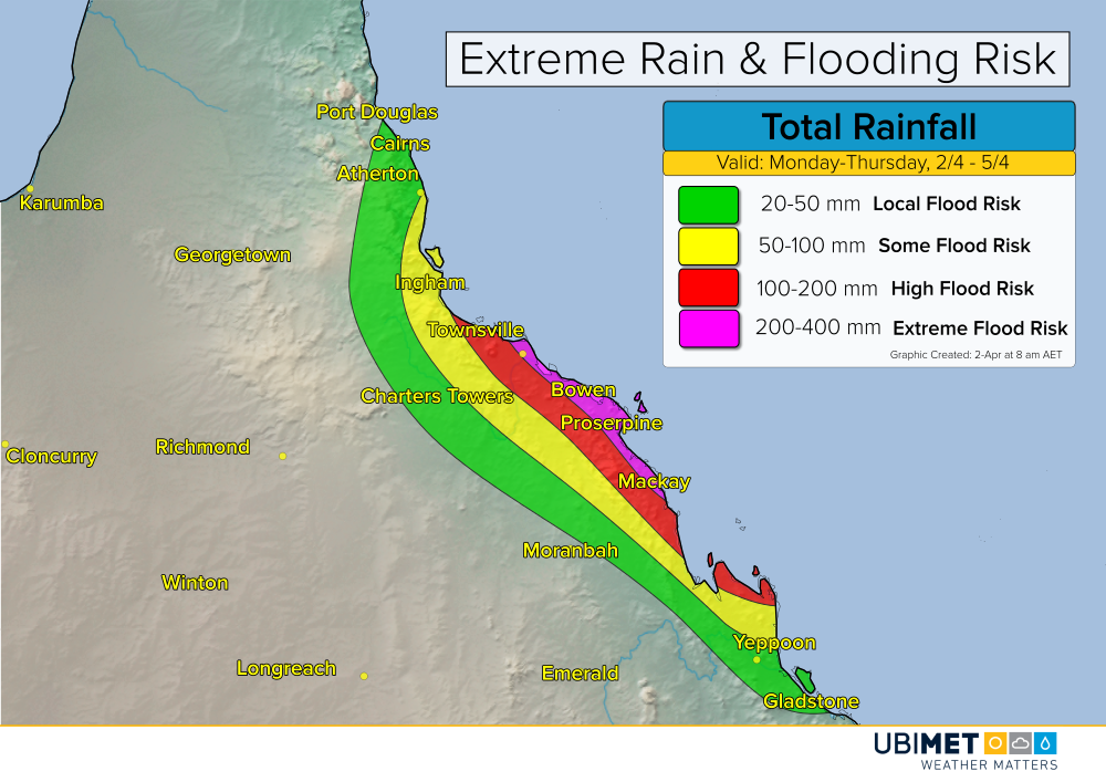
Extreme rainfall amounts are possible, particularly right along the coast. 5-day rain totals of 200-400 mm are possible. That is a rate of about 50-75 mm each day this week.

These types of falls will bring the risk for major and widespread flooding along the central QLD coast. Mudslides, washed out roads, and building damage due to flood waters are likely in regions that experience the heaviest rain.

Total rainfall expected from Monday through Thursday

Iris is expected to gradually weaken by this upcoming weekend. This will bring an end to the heaviest rainfall, however, scattered thundery showers are still expected to persist.

US Easter Day Forecast

Millions of Christians across the US will celebrate Easter on Sunday. What is the weather outlook for the holiday weekend?

Northeast

A cold front will cross the Northeast later Saturday afternoon and Saturday night. This will usher in a fresh chilly air mass to the region. Snow showers will whiten some landscapes across the mountainous areas of New York and New England, while blustery and dry conditions persist elsewhere.

Highlights:
  • Brisk and chilly
  • Mountain snow showers

Southeast

The cold front crossing the Northeast will stall out just north of the area. Consequently, mainly dry weather is expected across the Carolinas back to Louisiana. Easterly winds off of the Atlantic Ocean will bring some scattered showers to the Florida peninsula.

Highlights:
  • Mild and mostly dry
  • Scattered showers across the Florida peninsula

Central States

Some precipitation will develop across the Mississippi Valley along the end of the cold front. A mix of rain, sleet, and snow will fall across Missouri, while mainly rain falls from Oklahoma through Tennessee. Across the northern Plains, seasonably cold air will dominate Easter Weekend with temperatures failing to get to 0°C in the coldest locations.

Highlights:
  • Unsettled across the Mississippi Valley
  • Cold in the northern Plains

Northwest

An area of low pressure will move into the Northwest bringing a mix of valley rain showers and mountain snow. Snow levels will start the weekend between 1,200-1,500 meters, but then fall to around 500 meters on Easter Sunday. A fresh 10-20 cm of snow is likely above 1,500 meters, while 5-10 cm of snow is expected between 500-1,500 meters.

Highlights:
  • Valley rain showers and mountain snow
  • Snow level ~1,500 meters dropping to 500 meters

Southwest

Tranquil weather will dominate the Southwest for Easter weekend. Cool and crisp mornings will give way to mostly sunny and warm afternoons for many locations. Along the central and southern California coast, patchy morning fog will be around before the sun is able to burn through the fog by midday.

Highlights:
  • Dry and warm for many locations
  • Patchy fog along the California coast

Jelawat not a Threat to Land

Tropical Storm Jelawat developed in the West Pacific on Sunday, however, it is not expected to threaten any major landmasses.

Future Track Details

The center of Jelawat passed in between the island nations of Micronesia and Palau on Monday. The Micronesian island of Yap Island picked up over 180 mm of rain early this week as the center passed off to the west.

The storm will track northward through Wednesday, and then get steered toward the northeast thanks to a cold front moving southward from Japan.

West Pacific tropical outlook through this week

The expected curve to the northeast will keep the center of Jelawat far from any major landmasses.

Later this week, east-facing coastal locations of the Philippians, Taiwan, northward to Japan should expected to see rough surf. Direct wind and rain impacts are not expected.

Will Jelawat Strengthen?

Warm ocean water temperatures of 27-29°C have allowed Jelawat to acquire tropical characteristics. However, as the cyclone continues northward it will encounter stronger westerly wind shear. The wind shear will have a negative effect on Jelawat, and weakening is expected beyond Wednesday.

Global sea-surface temperatures. Jelawat is located within the blueish-purple circle.

Once the Jelawat turns toward the northeast, the cyclone is expected to lose its tropical characteristics as wind shear increases and sea-surface temperatures cool to below 25°C.

Flooding Threat For Paraguay & Southern Brazil; Cooler Argentina

A powerful early fall cold front will bring a risk for flooding rain and storms to Paraguay and southern Brazil on Sunday into Monday. Behind the front, a blast of cool fall weather will move into Argentina.

The Setup For Heavy Rain

The cold front will push northward and run into an environment conducive for heavy precipitation on Sunday. Cities such as Asunción and Pelotas are at risk for over 50 mm of rain, which could lead to areas of flooding.

Total precipitation accumulation Sunday and Monday

Additionally, thunderstorms will likely accompanying the frontal passage as it tracks across Paraguay and into Brazil. Widespread severe weather is not expected, however, some storms could bring damaging wind gusts.

Cooler Weather For Argentina and Uruguay

Behind the front, much cooler and drier weather is expected.

After 20-30 mm of rain in Buenos Aires on Saturday, it will dry out Sunday with high temperatures only reaching the mid to upper 10’s. The last time highs failed to reach 20°C in Buenos Aires was back on October 13th, 2017.

A similar cooling temperature trend is expected in Montevideo, Uruguay Sunday and continuing into Monday.