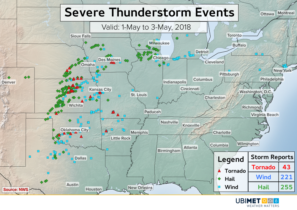
Heavy Rain & Severe Storms Target Argentina, Uruguay This Week

The potential for heavy rain and severe thunderstorms will exist through much of this week across central South America. Argentina, Uruguay, Paraguay, and southern Brazil are the countries most at risk for damaging thunderstorms and flooding rain.

The Setup

High pressure will setup to the east of Uruguay this week while low pressure will establish itself over the Gran Chaco region located just east of the Andes Mountains. Additionally, a second low pressure system will move into Chile later in the week.

Satellite imagery from Sunday shows low pressure off of the Chilean coast. This storm will move into Chile and eventually aid in heavy rain and severe thunderstorms across Argentina and Uruguay later Wednesday through Thursday.

The flow around the pressure systems will draw tropical moisture southward. The result will be numerous rounds of showers and heavy thunderstorms, some of which will be severe.

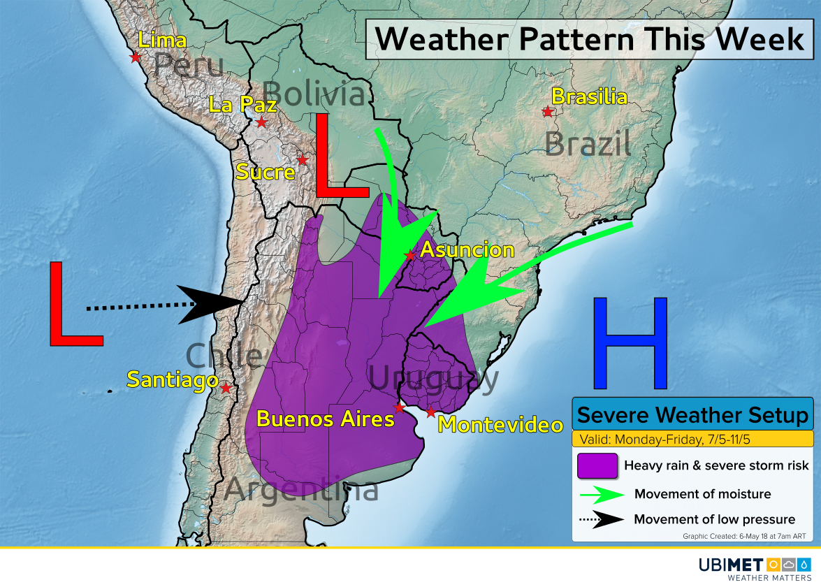
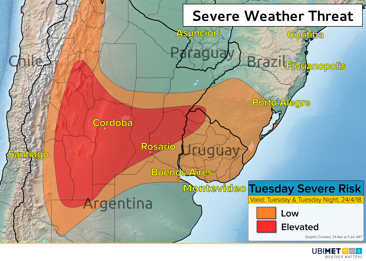
Initially, the heaviest rain and best chance for severe thunderstorms will exist across Paraguay and central Argentina through Tuesday. However, this threat area will shift toward eastern Argentina, Uruguay, and southern Brazil during the middle and end of the week.

The Impacts

Damaging winds, large hail, and torrential downpours capable of flash flooding are likely in the heaviest storms.

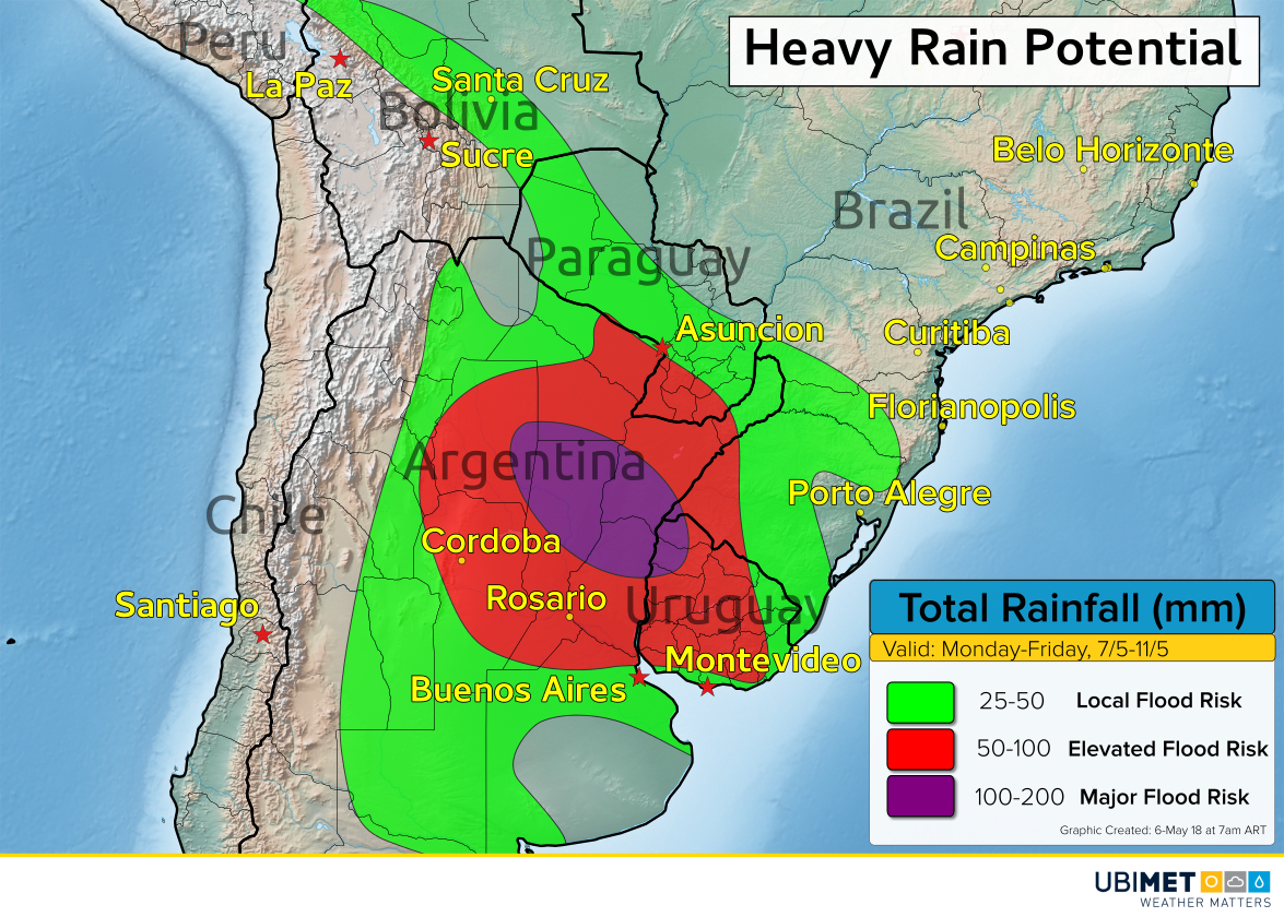
5-day rainfall totals of 100-200 mm are likely in a corridor from northern Argentina into parts of Paraguay. Outside of this area, widespread rainfall amounts of 25-100 mm are likely.

Weather models trends this weekend suggest that the period from Wednesday evening through Thursday and Thursday night may bring the greatest risk for severe thunderstorms and flash flooding.

Capital cities such as Asuncion, Buenos Aires, and Montevideo are within the threat area for heavy rain and severe storms, mainly from Tuesday through Thursday night. Other cities such as Cordoba and Rosario are also at risk for severe weather and flash flooding.

By the upcoming weekend, the risk for severe weather will end as a more tranquil fall air mass moves into the region.

Wild Week Of Severe Weather

The month of May got off to an active start with severe thunderstorms across the US.

The National Weather Service (NWS) recorded over 500 reports of severe weather from Colorado to New York state. The majority of the severe weather occurred across the central Plains from Texas to Iowa.

The most active day for severe thunderstorms in term of reports was on Wednesday when the Storm Prediction Center (SPC) reported a total of 232 severe weather reports.

One of the more impressive individual storms occurred on May 1st from a severe thunderstorm that produced a large tornado in Kansas. This particular tornado was captured by a storm chaser’s dash cam.


In addition to the severe storms, heavy rain and flash flooding was observed across portions of the Plains and Midwest. In just the first 3 days of May, a swath of 3-6 inches (75-150 mm) of rain fell from Iowa to Wisconsin.

The system responsible for the severe thunderstorms will be moving off of the East Coast this weekend giving a much need break from severe weather to the Central US.

Heavy Rain, Flooding Threat For Japan Tuesday Into Wednesday

Low pressure will pass through Japan on Tuesday into Wednesday bringing heavy rain and the risk for flooding.

The Details:

A moisture laden storm will cross Japan on Tuesday spreading moderate to heavy rain across the country. This area of low pressure gave Beijing it’s wettest day in more than 6 months this past weekend.

The track of the storm will bring the heaviest rain to the Kyushu, Chugoku, Kansai, and Chubu regions of Japan. 80-120 mm of rain is expected in some of the prefectures within these regions, particularly across the mountains. This amount of rain combined with the mountainous terrain will lead to areas of flooding.

Total rainfall expected Tuesday and Wednesday

For the Tokyo metro area, rainfall will average 20-40 mm. The rain will fall over the span of about 24 hours keeping the flood threat across the city rather low.

Rain will linger into Wednesday before tapering off and coming to an end Wednesday night.

Below is a weather model depiction of the storm total rainfall across Japan Tuesday and Wednesday.

Severe Storms Threaten Argentina On Tuesday & Tuesday Night

Severe thunderstorms are expected to erupt across Argentina during the midday and afternoon hours on Tuesday. Some of the severe storms are likely to push into Uruguay and far southern Brazil Tuesday night.

The Details

A disturbance will move off of the Andes Mountains and across Argentina on Tuesday. The disturbance will run into an unstable environment which will trigger the development of strong to severe thunderstorms.

Severe thunderstorm potential Tuesday and Tuesday night

The greatest risk for severe thunderstorms will be east of the Andes Mountains and include cities such as Cordoba and Rosario. In this area, damaging winds are the primary concern. However, frequent lightning and localized flash flooding can accompany any storm.

Buenos Aires will lay on the southern edge of the severe thunderstorm potential, with the greatest threat for severe weather expected just to the north.

On Tuesday evening into Tuesday night the severe risk will shift into parts of Uruguay and far southern Brazil.

A few lingering showers or thunderstorms will extend into Wednesday morning, but this these storms are not expected to be severe.