Alberto Tracks Toward Florida Panhandle

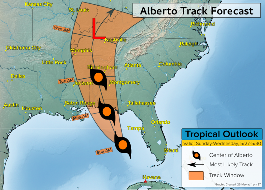
Tropical cyclone Alberto will move across the Gulf of Mexico and make landfall in the Florida Panhandle later on Monday.

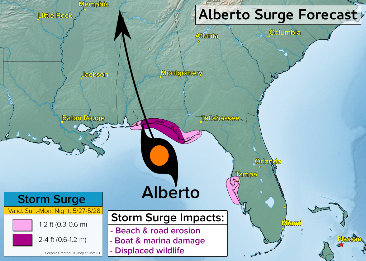
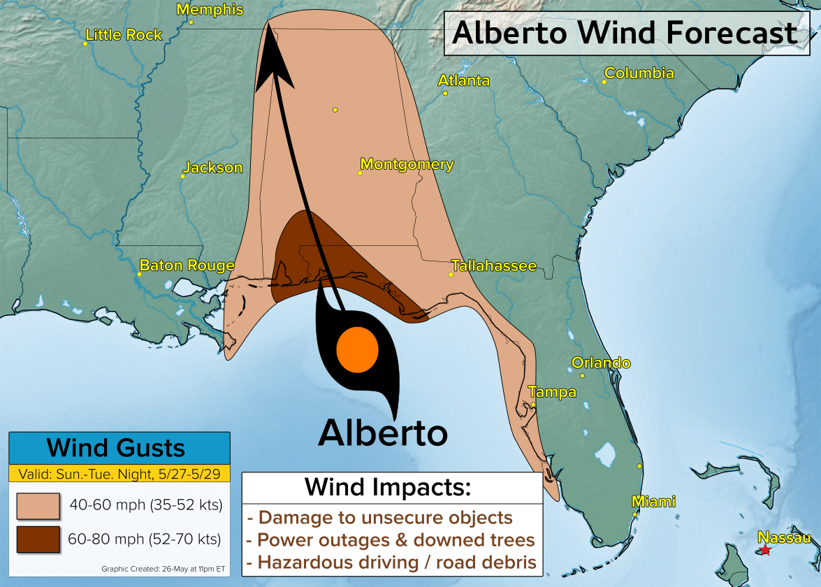
Alberto will impact several states across the Southeast, but affect Florida the hardest with damaging winds and widespread heavy rain. Across the Panhandle a storm surge of up to 2-4 feet is expected around the time of landfall.

Details on Alberto

Alberto will track across the warm waters of the Gulf of Mexico through Monday. Environmental conditions will favor some strengthening as the storm tracks toward the Florida Panhandle.

Landfall is expected between Mobile, Alabama and Apalachicola, Florida Monday afternoon or evening. A storm surge of up to 4 feet is expected near and just to the east of Alberto’s center.

The circulation around Alberto is large which means the wind field around the storm is also quite large. Consequently, tropical storm force winds of 39 mph or greater could extend up to 120 nautical miles from the center of Alberto.

 Alberto will also bring an abundance of tropical moisture northward from the Caribbean and Gulf of Mexico. The tropical moisture associated with Alberto will interact with a frontal boundary over the mid-Atlantic to bring a widespread area of heavy rain through Wednesday.

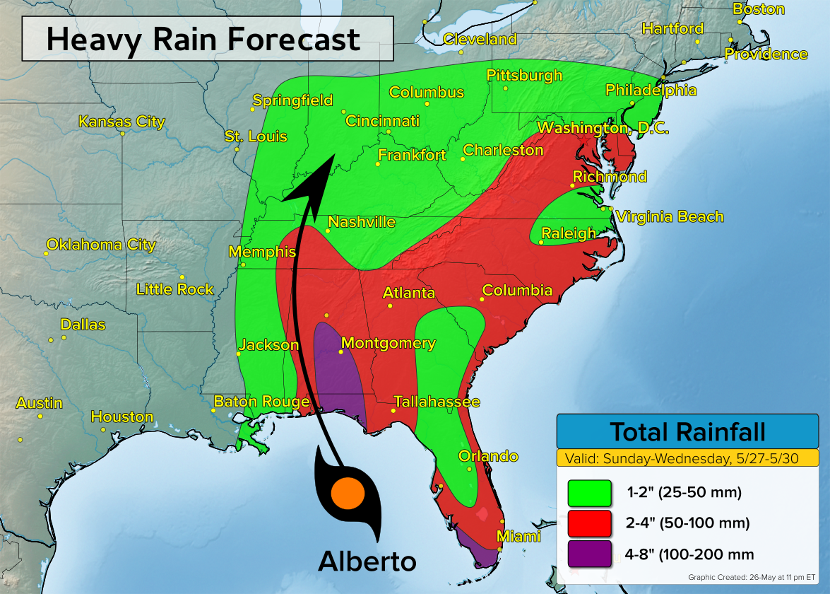
The heaviest rain is expected near and just east of the track of Alberto where 4-8 inches is expected. A second area of heavy rain is expected across southern Florida.

Across the Carolina’s and the mid-Atlantic, the rainfall expected will be due to tropical moisture moving in from the Atlantic Ocean and not directly from Alberto.

The wind risk from Alberto will diminish Tuesday night and Wednesday, but areas of heavy rain could continue across the Ohio Valley into Thursday.

Severe Weather To Target Brazil, Paraguay, Bolivia

Severe thunderstorms will threaten parts of Brazil, Paraguay, and Bolivia Friday and Saturday. Damaging winds, large hail, and flash flooding are all concerns.

The Setup

A cold front will move northward across central South America on Friday. Along and ahead of the front, the environment will be supportive for some damaging thunderstorms to blossom.

The greatest severe threat Friday afternoon and evening will extend from southern Brazil northwestward through Paraguay and into Bolivia. This includes cities such as Florianopolis, Asuncion, and Santa Cruz.

Damaging winds in excess of 80 kph, large hail up to 5 cm, and flash flooding will be possible in the strongest of storms.

The severe thunderstorm threat will diminish late Friday night into early Saturday, however, the severe threat will once again grow during the day Saturday as temperatures rise ahead of the cold front.

Cities such as São Paulo up to Brasilia will be at risk for some gusty to potentially severe thunderstorms Saturday afternoon and evening.

In the wake of the cold front, a cooler more stable fall air mass will move in and end the risk for severe weather.

Soggy Several Days Across Southeast and Mid-Atlantic

Rounds of rain and thunderstorms will track across the Southeast and mid-Atlantic through the rest of this week and this weekend. The soggy weather pattern will bring the risk for flooding in some areas.

How much rain will fall?

The heaviest rain is expected to set up across Virginia, Maryland, Delaware, and southern New Jersey through Sunday. In this corridor, 4-6 inches (100-150 mm) of rain is likely over a 5-day period. Outside of this region, a large area of over an inch (25 mm) of rain is expected.

It will not be raining the entire 5-day period at any one location, however, the expected rain combined with an increasingly saturated soil will bring some risks for flooding.

Why the wet pattern?

The culprits for the rain include a disturbance moving northward across the Gulf of Mexico, a second disturbance moving eastward across the Mississippi Valley, and a stationary front draped over the mid-Atlantic.

The slow movement of each of these features will keep rain chances high into this weekend.

A brief break in the rain is possible next Monday, but another disturbance will bring a risk for wet weather again next Tuesday.

Strong Fall Storm Targets SA, VIC, NSW, and TAS

The first major fall storm of the season is set to impact southeast Australia through the end of this week. Accompanying the fall storm will be rain and the potential for flooding, strong winds, and mountain snow.

Wednesday

A cold front will cross the Bight on Wednesday and move into coastal southeast AU by day’s end. Gusty showers and isolated thunderstorms will accompany the frontal passage. The cold front is expected to reach Adelaide on Wednesday evening and Melbourne Wednesday night.

Thursday

The cold front will sweep across southeast Australia on Thursday. Additionally, low pressure will develop near TAS and help drive strong south to southwesterly winds across the region. Gusts of 70-100 kph are likely along the coast as well as across the mountains.

Periods of rain will accompany the strong winds in many locations. Heavy rain will be likely near and to the west of the low pressure system. The heaviest rain on Thursday will likely be across TAS, especially near the Hobart area and surrounding hills.

In additional to the rain and wind, temperatures above 1,000 meters will get cold enough for the rain to change over to snow at times. A significant amount of snow in excess of 30 cm is likely at elevations above 1,300 meters between Thursday and Saturday.

Friday

Low pressure will drift northward on Friday continuing the strong wind and rain threat across much of southeast AU. Periods of heavy rain will spread northward across southern and eastern VIC.

The moist southerly flow on the west side of low pressure will combine with increasing elevation will bring an elevated risk for flooding to the VIC hills and Alps. The threat for heavy rain and flooding will continue across eastern VIC into Saturday.

The strongest storm-related impacts are expected to lighten up by Sunday, however, lingering showers and breezy conditions are likely from eastern VIC up to the central NSW coast.