Tropical Depression 5 Forms in South China Sea

Tropical Depression 5 (TD 5) formed over the South China Sea this weekend and could become Tropical Storm Ewiniar this week.
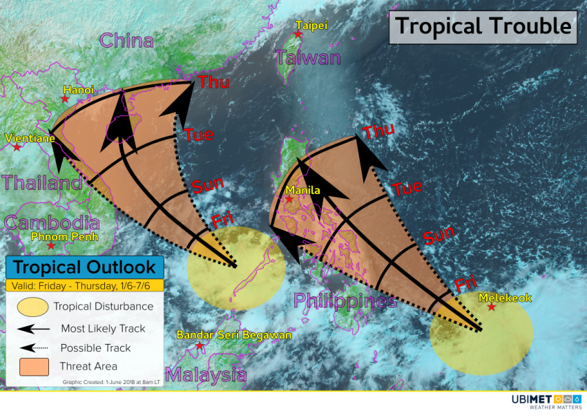
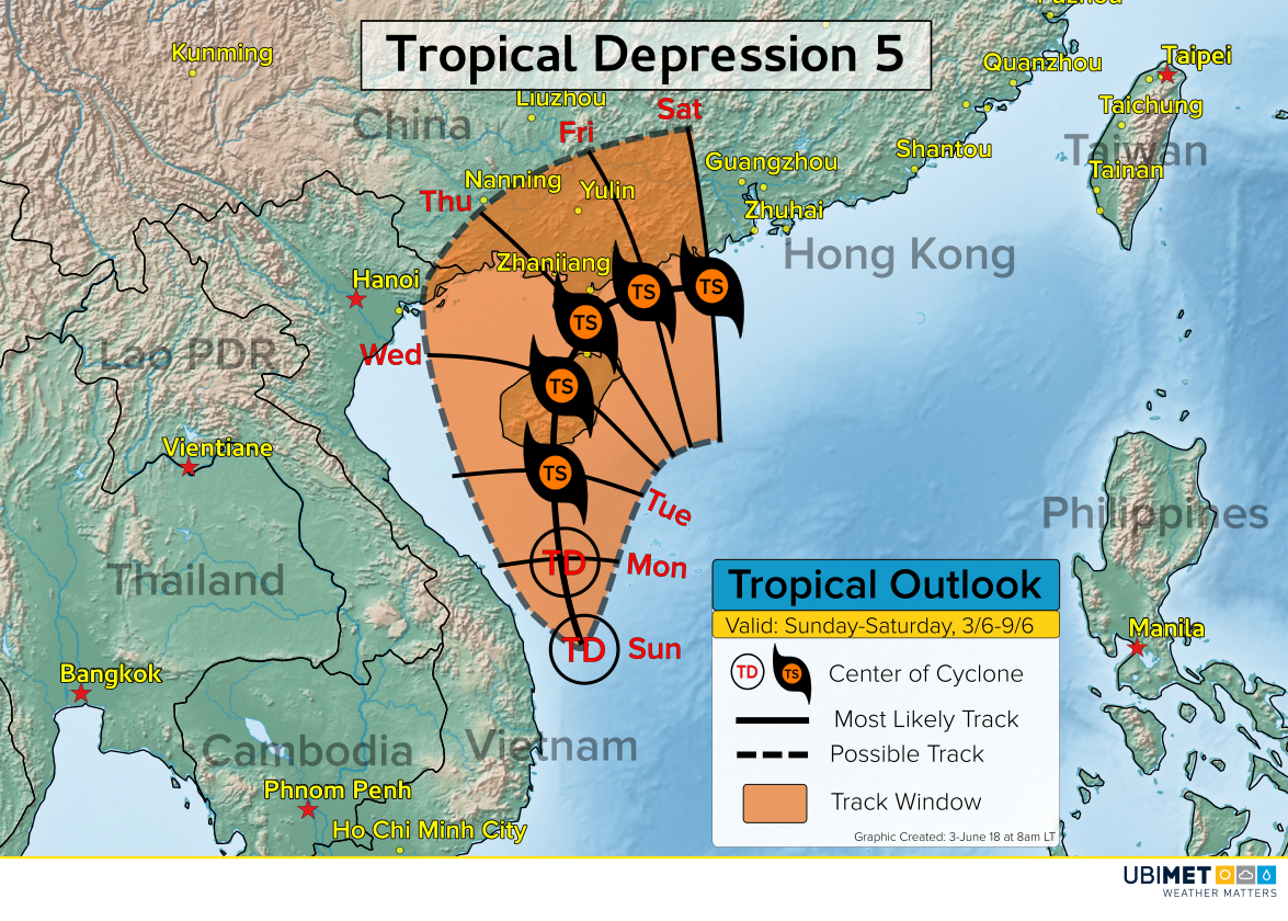
TD 5 Expected Track

The Details

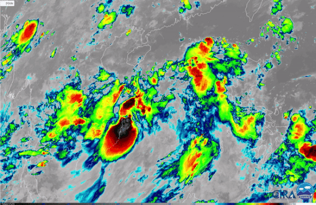
Satellite imagery over TD 5 shows the system is rather disorganized due to a moderate amount of easterly wind shear. Some gradual intensification is likely over the next couple of days, however, moderate wind shear through Monday will cap how strong the system can get.

TD 5 is expected to move in a northward direction over the next several days. This trajectory would take the system near or over the Chinese province of Hainan between Tuesday and Thursday.

Wind shear will weaken by the middle of the week allowing a more conducive environment for tropical development. If the center of TD 5 stays mostly out over water, the storm will have to be watched for additional strengthening between Tuesday and Friday.

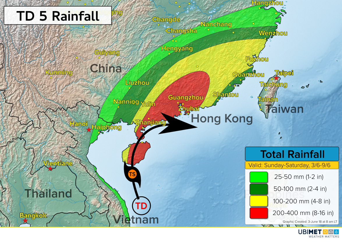
Regardless of strength, rounds of heavy rain and strong winds are likely across Hainan beginning on Monday and continuing for much of the week. A cold front moving across mainland China will draw moisture from TD 5 northward bringing the risk of heavy rain and flooding to a large area of southeast China.

TD 5’s track later in the week becomes more uncertain. If the cold front picks up the storm, then TD 5 will move in a easterly direction toward Taiwan. However, the TD 5 misses the connection with the cold front, the storm could meander in the South China Sea just off shore.

If the latter scenario pans out, there could be a more significant flooding threat to southern China.

Tropical Trouble in the West Pacific

Ubimet meteorologists will be monitoring a couple of tropical trouble spots in the West Pacific over the next week.

Tropical Disturbance #1

The first area of disturb weather is west of the Philippines with disorganized showers and thunderstorms.

Environmental conditions will be favorable for further organization over the next few days, and it’s possible a tropical cyclone could develop by the end of this weekend.

Steering winds will take this system toward the northwest this weekend into early next week. Toward the middle and end of next week, the weather pattern may favor a slower movement of this system. Consequently, interests from Vietnam to southern China should monitor the latest trends with this disturbance.

Tropical Disturbance #2

The second tropical feature of interest is located to the southeast of the Philippines. Similarly to the first disturbance, this second system will be in an environment that is favorable for tropical development over the next several days.

The steering winds will carry this disturbance toward the northwest this weekend and next week. Interests in the Philippines should continue to monitor the latest trends as rain and wind impacts are possible in parts of the country as early as Tuesday.

Climatology

The Western Pacific Ocean is no stranger to tropical cyclones. However, climatology indicates that the two systems that are being monitored are a bit too far south for cyclone development.

Flash Flooding Inundates Ellicott City, Baltimore Area Sunday Afternoon

A persistent area of showers and thunderstorms have brought severe flash flooding to the Baltimore, Maryland suburb of Ellicott City Sunday afternoon.

Thunderstorms developed in the area just after 2 pm local time and became nearly stationary for almost hours dropping 7.47 inches of rain on the town. At one point, 1.30 inches of rain fell in just 15 minutes; a rate of 5.20″ per hour.

The following are a series of tweets containing pictures and videos from people that were in Ellicott City as the flash flooding was occurring.

Tweets from the Ellicott City flash flooding

Myanmar Braces For A High Risk Of Flash Flooding Risk This Week

Rounds of heavy rain and thunderstorms will bring a significant risk of flash flooding to Myanmar this week.

Myanmar Heavy Rain Details

The heaviest of the rain is expected from Monday through Wednesday across the north-central coast of Myanmar.
A high risk for flash flooding will exist which includes impacts such as mudslides, washed-out roads and bridges, as well as an increased likelihood for water contamination.

200-400 mm of rain is likely across central Myanmar, which includes Naypyidaw and Yangon (listed as Rangoon on the maps in this article). Elsewhere, a widespread area of over 100 mm of rain is expected over a 3-day period.

UBIMET meteorologists are tracking a disturbance across the Bay of Bengal that will send tropical moisture from the Indian Ocean northward. This tropical moisture will be the fuel for the heavy thunderstorms.

The heaviest rain risk will diminish on Thursday and Friday, but lingering moisture will still bring a risk for scattered showers and storms into the upcoming weekend.