
Residents of the central Mexican Pacific Coast left for work on Tuesday morning with Tropical Storm Otis meandering offshore. By mid-evening, Otis had strengthened faster than almost any hurricane in history. Otis roared into the tourist hot spot of Acapulco Tuesday night as a Category Five, wreaking havoc with only hours of warning.
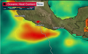
The tropical cyclone season in the Pacific and Atlantic Basins is typically winding down by late October. However, a pocket of very warm ocean water lingers off the central Pacific coast late into the autumn (see image above). This was precisely the region that Otis moved over as it approached the Mexican coast on Tuesday. Forecasters knew there was a possibility of some intensification leading up to landfall. However, the rapid strengthening Otis experienced was beyond any reasonable prediction (see satellite animation below).
.@NOAA‘s #GOESWest 🛰️ watched as #HurricaneOtis strengthened from a tropical storm to a Category 5 hurricane in only about 12 hours.#Otis made landfall near Acapulco, Mexico around 1:25 am CDT today with sustained winds of ~165 mph.
Latest:https://t.co/yi6nrBfQ4g pic.twitter.com/oHgDSc1t5H
— NOAA Satellites (@NOAASatellites) October 25, 2023
OMG this is the Princess hotel in Acapulco. That’s some serious damage!!! 😫 #HurricaneOtis #HurracanOtis #Otis #Acapulco #México pic.twitter.com/pR10cjxsSv
— Whitney Wells (@WellsWhitn91295) October 26, 2023
⚡️⚡️⚡️ #URGENT | Category 5 #Hurricane #Otis made landfall in #Acapulco, #Mexico. pic.twitter.com/MINEbaiaun
— WTF-NeW (@WTFNeW8) October 25, 2023
Otis slammed Acapulco and nearby communities with sustained winds up to 165 mph (265 kph). It was by far the strongest hurricane to strike that region in recorded history. Photos and videos from the scene show nearly all windows blown out of hotels and residential high-rises. The buildings were subsequently hollowed out by the high winds. Trees were stripped of branches and debris littered area roadways. Landslides closed many roadways, and officials reported that communications had been completely cutoff at one point on Wednesday. Fortunately, the hurricane dissipated as fast as it intensified after hitting the interior mountains of central Mexico.