The stormy late-season pattern continues in the western U.S. The latest storm brought more flooding rains and mountain snows. It also spun down a rare tornado in the L.A. Basin, damaging buildings and cars. On a positive note, the abundant rainfall has refilled numerous lakes and reservoirs in the region that had been decimated by drought in recent years. Springtime snow melt will bring additional flooding potential and lake replenishment.
BREAKING: Tornado touches down in Montebello, CA.
Watch as the tornado touches down and causes damage to businesses in the area. It has been reported that one person sustained injuries, and several buildings have substantial damage. pic.twitter.com/rP3uxXWuRo
— Los Angeles Magazine (@LAmag) March 22, 2023
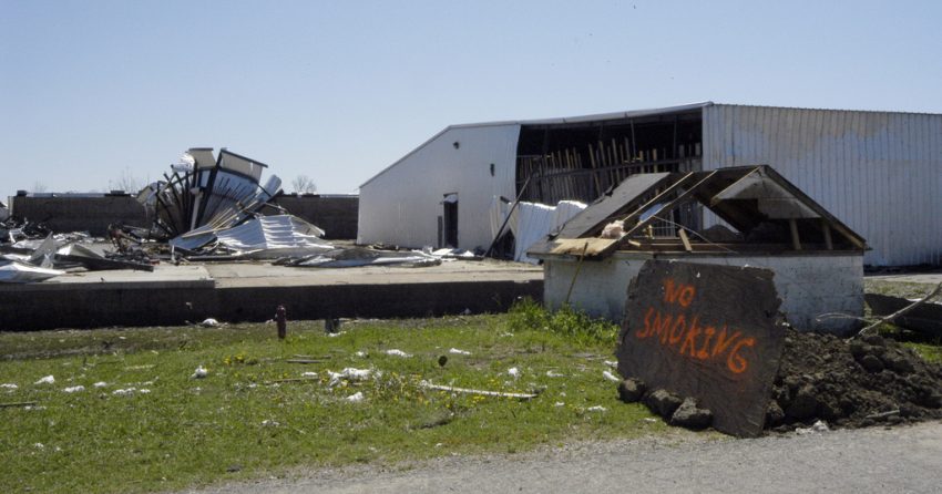
The tornado, rated EF1 after a survey by the National Weather Service damage assessment team, was the strongest to hit the Los Angeles metro area in forty years. Tornadic winds up to 110 mph (177 kph) tore roofs from a dozen buildings and destroyed several cars (see video above). It was the second tornado to hit southern California in the past week. The same system brought damaging winds to mountain communities just south of San Francisco after rapidly intensifying just offshore (see video below). At one point more than 700,000 Californians were without power due to the storm.
STORM DAMAGE | Viewer video shows the storm damage along Highway 236 in Boulder Creek. The high winds knocked over trees and power lines, blocking many roads across the Central Coast. pic.twitter.com/eAFjdu6usQ
— KSBW Action News 8 (@ksbw) March 21, 2023
The active weather pattern has actually been beneficial for many parts of California and neighboring states. Snowpack statewide is running nearly twice as much as normal and some ski resorts are making plans to remain open through July. Indeed, some resorts have gotten so much snow that lifts are unable to run (see video below). One station near Lake Tahoe in the Sierra Nevada range has reported 677 inches (17.2 m) of snowfall this winter.
Snow is so high south of Tahoe they can’t run the lifts 😂 #CAwx #NVwx pic.twitter.com/r2yRBGTawU
— Holden LeCroy (@Holden_WX) March 19, 2023