Hurricane Ian, the ninth storm of the 2022 Atlantic hurricane season, is now on a collision course with the central-west coast of Florida. Ian made landfall early on Tuesday morning in the Pinar Del Rio province of western Cuba. The storm roared ashore with winds of 125 mph (201 kph), which toppled power lines and damaged many homes. These winds are also responsible for delivering substantial damage to the heavily prized tobacco crops. The entire nation, or 11 million people, are currently without power in the wake of the storm, as the storm has caused the ailing power grid to fail. Ian is responsible for two deaths across the island so far.
#HurricaneIan leaves a trail of destruction across Cuba. https://t.co/XqY1v75rev pic.twitter.com/aiut4G9KyI
— AccuWeather (@accuweather) September 27, 2022
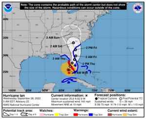
Upon remerging in the Gulf of Mexico after departing Cuba, Ian has now explosively grown into a monster Category 4 storm, packing winds of 140 mph (225 kph). It is certainly possible that further strengthening is possible as Ian churns over water that is extremely warm, ranging from 85-90 degrees F (29-32 C), before a landfall on the west-central coast of Florida later on Wednesday. 2.5 million Floridians have been put under mandatory evacuations as the storm draws near. Ian is expected to bring widespread damaging winds to a large swath of the state, as the storm slows down after landfall. This slowing down will also lead to very high amounts of rain falling. Rainfall amounts between 10-15 inches (254-381 mm), with locally higher amounts of up to 25 inches (635 mm) will cause catastrophic flooding. A storm surge of up to 12 feet (3.6 m) is also possible along the coast.
Key West resident Dylon Estevez walked three blocks carrying his dog through waist-deep water to escape his flooded apartment.
The flooding is a result of a Hurricane #Ian storm surge. pic.twitter.com/t2rnPCwAO3
— The Weather Channel (@weatherchannel) September 28, 2022
Here is the latest rainfall 5-day rainfall forecast for Hurricane #Ian Created 4:38 AM EDT 9/28 pic.twitter.com/qMl8AMwHGZ
— National Hurricane Center (@NHC_Atlantic) September 28, 2022
As a whole, the state of Florida is no stranger to hurricanes, receiving the majority of all landfalls in the United States, however, the central-west coast of the state has been particularly lucky in recent years. Aside from Hurricane Charley, which devastated the Punta Gorda region in 2004, the remainder of the central-west coast has dodged many bullets. Tampa, the second largest city in the state, is a prime example, having not received a direct hit from a hurricane since 1921. It is possible Ian may break that streak, or in the very least bring more damage to the area than seen in quite some time. After leaving Florida in ruins, Ian is forecasted to move northward, and bring flooding rains to Georgia and the Carolinas by the weekend.
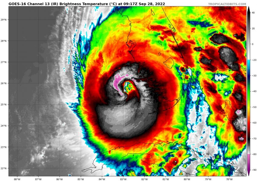
Eye diameter of #Ian about 35 miles across, a larger hurricane after Tue night eyewall replacement cycle. Entire extent of hurricane force wind field of Charley 2004 would fit inside Ian’s eye. This will produce a much wider swath of damaging wind, storm surge, flooding rains. pic.twitter.com/DWbRzIY8ps
— Dr. Rick Knabb (@DrRickKnabb) September 28, 2022
Outflow from Hurricane #Ian contributing to an extensive band of cirrus over the Atlantic Ocean. pic.twitter.com/80mcDeq0RM
— Andrew Miskelly (@andrewmiskelly) September 28, 2022
When all is said and done, it is very probable that the name Ian will be retired from the list of Atlantic hurricane names, as damages will likely top out in the billions of dollars. If this occurs, it would be the 13th I storm to be retired, falling into the category of most devastating storms in history which include: Ivan, Irene, and Ida. The letter I has the most retired names associated with it. This is due to it being the ninth letter on the list, which usually coincides with the peak of activity in the season.