Cyclone Imogen, the first tropical cyclone of the 2020-21 Australian tropical cyclone season, made landfall near Karumba, Queensland late on Sunday night. The Category 1 storm, which formed over the weekend in the very warm waters of the Gulf of Carpentaria, had sustained winds of 65 kph (40 mph) at the time of landfall.
Tropical #CycloneImogen‘s structure has changed, transitioning the system to a tropical low. Despite the name change, the rainfall is going to increase with widespread heavy rain & flooding expected. Damaging winds still possible with storms in the area. https://t.co/PXWp1ezyAK pic.twitter.com/6zH2H9Db2I
— Bureau of Meteorology, Queensland (@BOM_Qld) January 4, 2021
With gusts over 100 kph (65 mph) in some locations, some minor damage has been observed across the Gulf Country region of the state, and no injuries or deaths have been reported thus far. While most structures were spared from destruction, many trees have been felled by Imogen. Over 1400 people have lost power due to the storm. Although notable, the winds from Imogen were not as impressive as the rainfall totals it brought. For example, Normanton Airport received 259 mm (10 in) overnight. 186 mm (7 in) of that fell within just 3 hours. Many other locales have received 150- 265 mm (6-10 in).
Found out why Cairns Esplanade was closed outside the hotel…. ‘Ex’ cyclone Imogen visited today…..🙈 #cairns #fnqld #wetseason #CycloneImogen #excycloneimogen pic.twitter.com/PoWFUstM2n
— DJ O’Brien (@DJsMakeUpldn) January 4, 2021
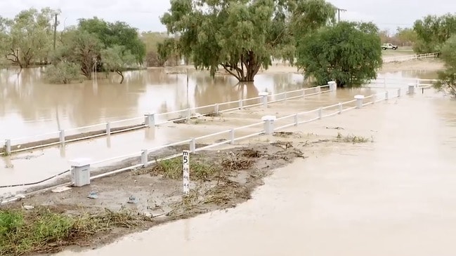
Flash flooding has also been very immanent across the Far North region as swollen rivers have come over their banks. The floodwaters have swallowed roads and inundated farmland. One homestead near the town of Giru was completely cut off from road access due to the flooding. The head farmer of that homestead says this an annual occurrence though. He just waits it out.
✋ PLAN B ✋
If flooded roads are blocking your usual way to work, home, school or daycare, have a Plan B.
With Ex-Tropical Cyclone Imogen causing heavy rainfall, think about others ways you can get from A to B without putting your life in danger.
If it’s flooded, forget it. https://t.co/iy2FsSgHTa
— Qld Fire & Emergency (@QldFES) January 4, 2021
Imogen, now a remnant tropical low, will continue to move slowly to the south and east towards the North Tropical and Herbert-Lower Burdekin coasts over the next few days. Heavy rainfall is expected to continue during this timeframe, with totals possibly exceeding 400 mm (16 in) by the time it’s all said and done. Rainfall totals of this magnitude will almost certainly lead to more flash flooding. Despite this threat, many farmers and ranchers are very pleased to see the rain, especially given that the wet season got off to a late start this year.
A decent downpour in Cairns. Apparently the heavy rain will come later as the impact of #CycloneImogen (which made landfall 750km west of here) is felt in Far North Queensland. pic.twitter.com/uiztPLSs6k
— Simon Atkinson (@atko1978) January 4, 2021