
Tropical Storm Zeta is accelerating over the central Gulf of Mexico. Intensification is expected and Zeta will likely be a hurricane as it approaches southeastern Louisiana on Wednesday. Zeta will bring heavy rain, damaging winds, and a dangerous storm surge to sections of the central Gulf coast that have already been battered by multiple storms this season. After landfall, Zeta will transition to an extratropical system. It will encounter enough cold air over New England to result in the first significant snow of the season!
Tropical Storm #Zeta is intensifying tonight.
An increasingly-defined eye on satellite, with some new convective bursts around it likely to strengthen the circulation.
Meanwhile, upper-level anticyclone and healthy outflow.
Maybe high Cat-/low Cat-2 at landfall. Surge danger. pic.twitter.com/UPuwxkz18s
— Matthew Cappucci (@MatthewCappucci) October 28, 2020
Zeta is the 27th named storm of the Atlantic hurricane season, one shy of the record. It struck the Yucatan peninsula on Monday as a hurricane, the third of the season to hit the Mexican state of Quintano Roo, a new record. Zeta weakened back to tropical storm status after interacting with land. However, satellite imagery shows Zeta is intensifying as of Tuesday night. Zeta is accelerating and will approach southeast Louisiana by mid-afternoon. It’s likely to be the 11th named storm to make landfall in the continental U.S., shattering the previous record. The rapid speed of the storm could decrease the threat for flash flooding due to rainfall. However, damaging winds and storm surge could be enhanced. Gusts as high as 90 mph (145 kph) will level many trees and powerlines, leading to widespread power outages. Surge flooding as high as 6-8 feet (2.5 m) will pummel the coast from far southeast Louisiana to southern Mississippi and Alabama, a potentially deadly hazard for those who failed to heed evacuation orders. Conditions will improve in this region by Wednesday night as the storm pulls rapidly away.
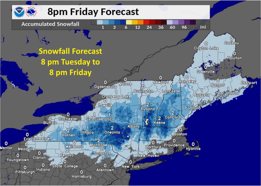
The remnant circulation will merge with a northern jet system over the Northeast U.S. later this week. Tropical moisture will spread across the Mid-Atlantic and New England, leading to some minor flooding. However, over higher elevations the precipitation will fall as wet snow, leading to significant accumulations of up to 3-6 inches (7-15 cm) in some spots (see map above). A few flakes may even fly closer to the big cities along the coast by Friday as the system moves offshore. Hurricanes transitioning to winter storms are quite rare, but not unheard of. The infamous Superstorm Sandy, which started as a hurricane in late October 2012, dumped snows up to 2-3 feet (60-90 cm) in the central Appalachians! Zeta won’t muster that kind of accumulation, but a few inches of wet snow could still result in travel disruptions for interior New England on Friday.