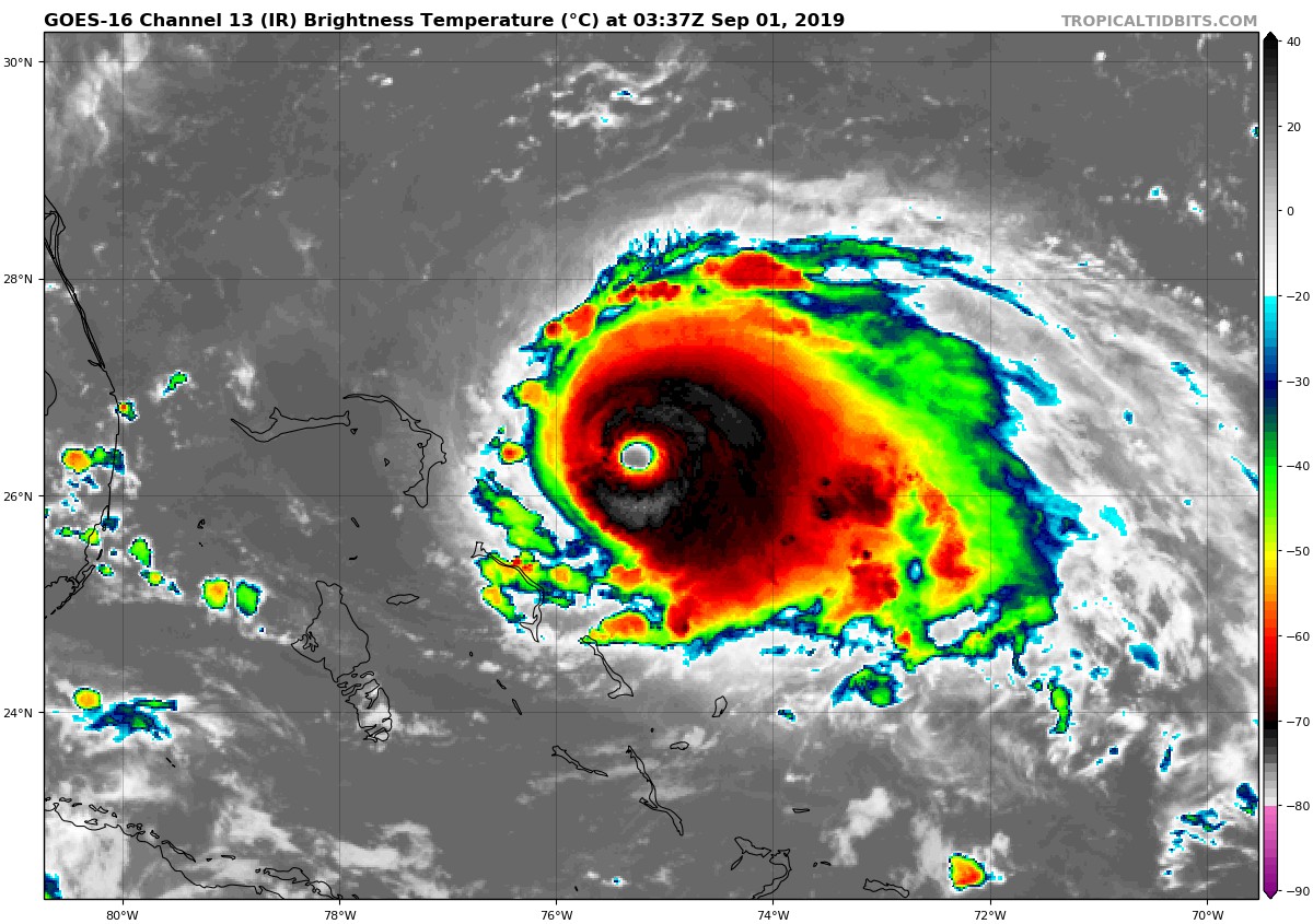
Hurricane Dorian once again has strengthened within the last 24 hours. The Category 4 storm, currently positioned to east of the Bahamas, has sustained winds of 150 mph (241kph), which is only 7mph shy of Category 5 status. It is very possible the storm may reach Category 5 status in the coming days, as it is forecast to move over a deep layer of very warm water, just east of the northern Bahamas. Dorian is also moving quite slowly, at 8mph, which will allow the hurricane to tap into the energy from that warm water. Coupled with a favorable upper atmospheric environment, weakening is highly unlikely in the near future. Dorian’s satellite presentation continues to look outstanding. With a well defined eye, and near perfect symmetrical shape, Dorian is a classic looking text book hurricane.
Although Dorian has maintained it’s intense strength, one thing that has changed dramatically is his track. As of yesterday, it was looking as if a landfall along Florida’s east coast was likely, but as of today, it seems that Dorian may move northward into the Carolinas instead. New forecast data coming in has suggested that an upper level trough of low pressure will steer Dorian more to the north, sparing the Florida peninsula of a direct hit. This may be good news for Florida, however, that does not mean the state will be completely free from the dangers of this hurricane. Fringe effects are still very possible, which has led to tropical storm watches being issued earlier today along Florida’s east coast.
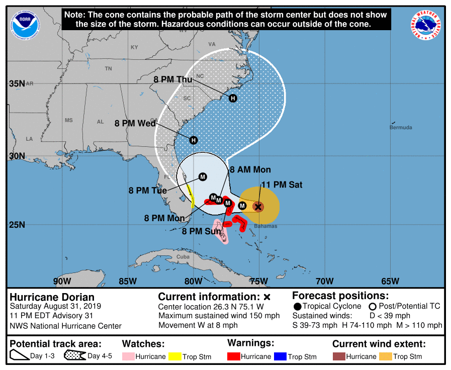
As one state breathes a sigh of relief, (sort of), three other states are now on high alert. In addition to Florida already being under a state of emergency, the governors of both North and South Carolina have issued a state of emergency earlier today. The coastal counties of Georgia are also under a state of emergency. Another hurricane is that last thing these three states want to see, as they are all still reeling from the effects of hurricanes Matthew, Michael, Irma, and Florence; all within the last three years.
The track of Dorian remains uncertain it this time, as not all of the forecast models are in agreement of where the storm will go. The general consensus, as of now, it that Dorian will not make a landfall at all in the United States, but just skirt the coasts of Florida, Georgia, South Carolina, and North Carolina, before turning out to sea later next week. There are several models that do show a landfall along the South Carolina coast, while a few outliers still show a landfall in Florida. Even without a landfall, Dorian is very likely to bring devastating effects to the aforementioned states in the form of high winds, heavy rains, coastal flooding, and beach erosion. Dorian’s timing will also coincide with the presence of King Tides ( astronomical higher tides that happen seasonally), which will enhance coastal flooding significantly.
One thing that is certain, is that a prolonged period of life-threatening storm surge, devastating hurricane-force
winds, and heavy rains capable of life-threatening flash floods are
expected on the Abaco Islands and island of Grand Bahama in The
Bahamas Sunday through Monday, and a hurricane warning is in effect
for these areas. As Dorian passes through The Bahamas, and slowly
approaches the southeast coast of the United States through the
middle of next week, it is possible the track may change once again.
Nonetheless, all residents within the path of the storm should remain
vigilant, and heed all warnings and orders of evacuations from the
authorities.