Tropical Storm Dorian has maintained strength on Tuesday, passing through the Leeward and Windward Islands early this morning (see tweet below). Puerto Rico now looks to be threatened by a direct landfall as the cyclone has taken a more northerly course. A state of emergency has been declared for the island. After that, the storm looks to enter an area of open ocean with conditions ripe for intensification. The risk of a significant impact in the southeastern U.S. is increasing!
#HurricaneDorian flooding in Isla Margarita right now #TropicalStormDorian #Dorian 🌀⛈️🚨 pic.twitter.com/JB0K2HzJzk
— Máximo Alexander (@MaximoSPQR) August 27, 2019
Islands in the eastern Caribbean saw high winds and very heavy rainfall as the storm moved through Monday night and Tuesday morning. However, persistent dry air at the mid- and upper levels has continued to hinder Dorian from intensification. Fortunately for residents of Puerto Rico and nearby islands, this dry air along with increasing interaction with mountainous terrain on the larger islands will likely prohibit significant strengthening until the storm clears the region. Major impacts are still likely, especially heavy, flooding rainfall in the mountains of central and southern Puerto Rico. The worst impacts will probably be felt on Puerto Rico from midday Wednesday into the overnight, with conditions improving Thursday morning.
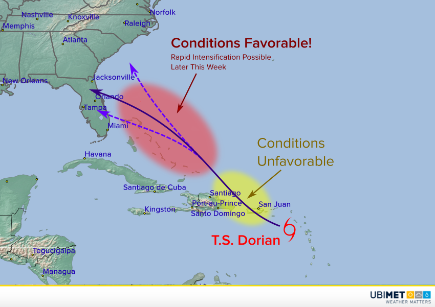
Dorian will move into the eastern Atlantic for the late week. Conditions there will be better for intensification, including warm ocean waters, light shear, and more moist air aloft. Model guidance is starting to suggest the cyclone will intensify significantly and turn more towards the west-northwest. Model reliability decreases significantly in the 4-5 day time frame, but residents of the southeast U.S. should monitor the storm closely and make sure their hurricane plans are ready to be implemented if necessary.