The coldest air mass in decades is pressing east and southeast tonight from the Midwest to the Great Lakes. Temperatures have just fallen below zero °F in Chicago and may not rise back above until late Thursday or early Friday. Wind chills in the Windy City and elsewhere will plummet to life-threatening low levels through the next few days.
A chunk of frigid Arctic air has descended behind a deep upper-level trough from Canada into the central U.S. It will eventually expand to include the Great Lakes and Northeast by Wednesday into Thursday. Widespread snow cover will help temperatures fall well below zero across much of this region, as cold as the minus 40s °F over portions of the Upper Midwest. Low temperatures in Chicago the next two nights will be some of the coldest the city has ever recorded. The all-time record low of minus 27 °F at O’Hare International Airport will be threatened Wednesday night.
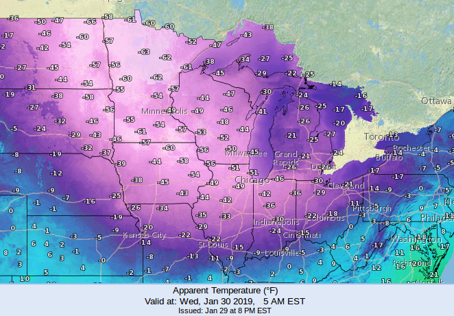
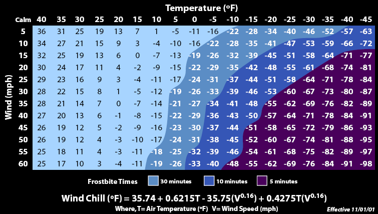
Winds will remain somewhat gusty at least through tonight into Wednesday. The combination of winds and frigid temperatures will plunge wind chills into the minus 50s and 60s (see graphic above from the National Weather Service). The graphic below shows the dangerous health effects associated with this kind of extreme cold. Wind chills in the forecast range of the next few days will lead to frostbite of exposed skin within just a few minutes. Prolonged outdoor activity should be avoided if at all possible! Fortunately, a rapid warm-up will defrost much of the region late in the week and into this weekend.