
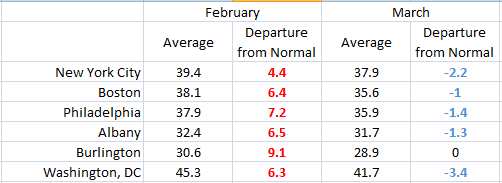
Through the month of February, residents of the Northeast could afford to chuckle at the “six more weeks of winter” promised by the fabled groundhog. Many cities reported among their warmest Februarys ever with clear days and little snowfall.
Then March hit. In the last 3-4 weeks there have been no less than four major Nor’Easter storms, bringing record snowfall and frigid temperatures. The table shows average temperatures for the major cities – note that March so far has been two to three degrees colder than February (all temperatures in deg Fahrenheit). Other areas of the globe have seen anomalous weather as well, from bone-chilling cold and snow in Europe to record warmth in the Arctic Circle.
One major factor that could help explain the topsy-turvy weather pattern is a particular phase of the North Atlantic oscillation, or NAO. The NAO is a fluctuation in surface pressure patterns over the Atlantic ocean. During much of February the NAO was in its positive phase (see graphic below), a situation that usually results in quiet, mild weather. However, from late February into early March the NAO plunged into deeply negative territory. In the negative phase of the NAO, the upper level jet stream that moves storms and air masses around becomes highly amplified. Warm air from the tropics can rush north into the Arctic, displacing frigid air down to the south over eastern North America or Europe. This turbulent pattern promotes more frequent development of winter storms over the U.S. Eastern seaboard and western Europe.
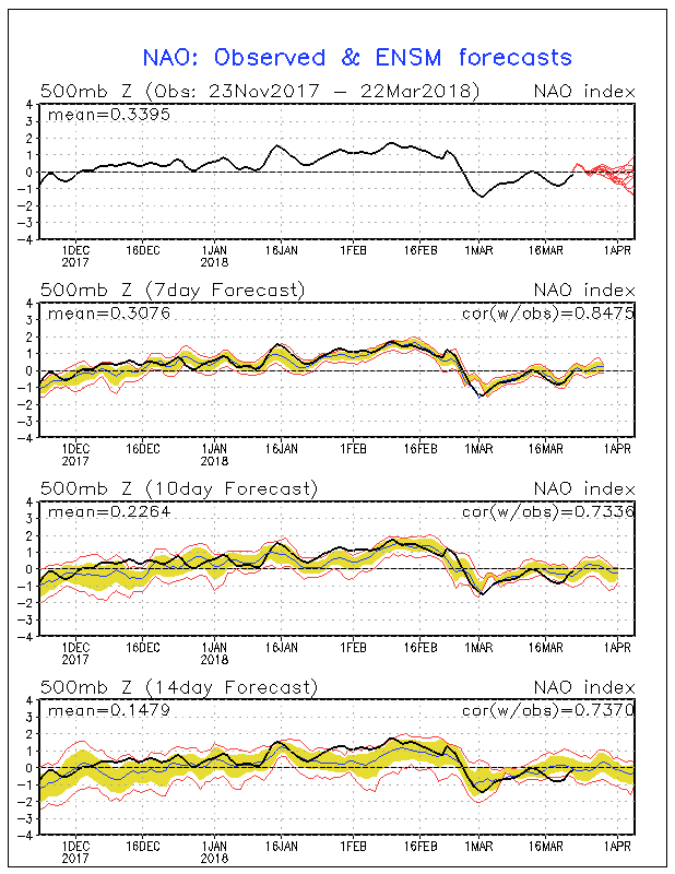
The NAO is currently forecast to trend a bit more towards the neutral phase. That combined with lengthening daylight hours should finally bring winter to a close in the next few weeks. But those that were fooled by the mild February have learned their lesson.