Meteorological winter ended this week as February came to a close.
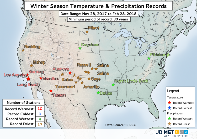
Preliminary data from the Southeast Regional Climate Center shows that across the Southwest U.S. many stations experienced either their warmest or their driest winter on record.
For example, Los Angles International Airport was +2.14 F above average during the December-February period that defines meteorological winter. That value is enough to qualify as the warmest anomaly in the station’s 74 year history. Elsewhere, several other stations in southern California and across the Southwest broke records for winter warmth.
There were no stations in the contiguous U.S. that experienced their coldest winter on record.
Precipitation-wise, record dryness was observed from northeast New Mexico out into central Kansas. It was so dry across portions of southwestern Kansas that Garden City actually went through meteorological winter without recording any measurable precipitation.
To the southeast of the record dryness was a zone of much higher precipitation. Dallas, Texas and areas around Little Rock, Arkansas experienced their wettest winter period on record. Records at these observation station go back 44 years and 42 years, respectively. The stripe of above average precipitation continued northeastward to Pittsburgh, which saw its wettest winter since at least 1948.