
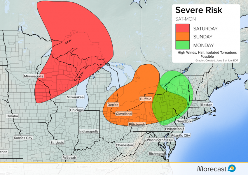
Storm system trekking across the northern U.S. border will bring chances for severe weather through Monday for the Great Lakes and Northeast.
System’s History
Yesterday, northeast of Calgary, Alberta, this storm system produced this picturesque tornado.
Stunning tornado from Canada yesterday by @vanceneudorf. Thankfully only minor damage reported… https://t.co/Z2ngGemMwy
— Dan Holley (@danholley_) June 3, 2017
Forecast
This system has now moved into the Great Lakes region. Plenty of heat and moisture are available to produce severe storms through the Upper Great Lakes region Saturday. While a tornado cannot be ruled out, the favored storm dynamics to produce tornadoes will remain to the north, in Ontario. The main threats for Saturday, mainly through the U.P. of Michigan and Wisconsin, will be high winds and hail.
As we head into Sunday, this system will merge with a second upper-level system, bringing severe storm chances into the eastern Great Lakes region. The system will strengthen overnight Sunday, continuing a severe storm threat through portions of the Northeast into Monday. High winds and hail will be the main threats with these storms, along with a tornado or two.
Make sure to follow us on Facebook and Twitter for the latest on this severe weather.