(Updated at 10 a.m. EDT Monday, 4/24)
A storm system that moved into the Carolinas Sunday night will continue soaking the region the rest of Monday into early Tuesday. The drenching rains may exceed 6 inches in some areas leading to risk of flooding. In addition to the heavy rain, the storm system may also trigger some severe thunderstorms later in the day Monday.
Latest Update
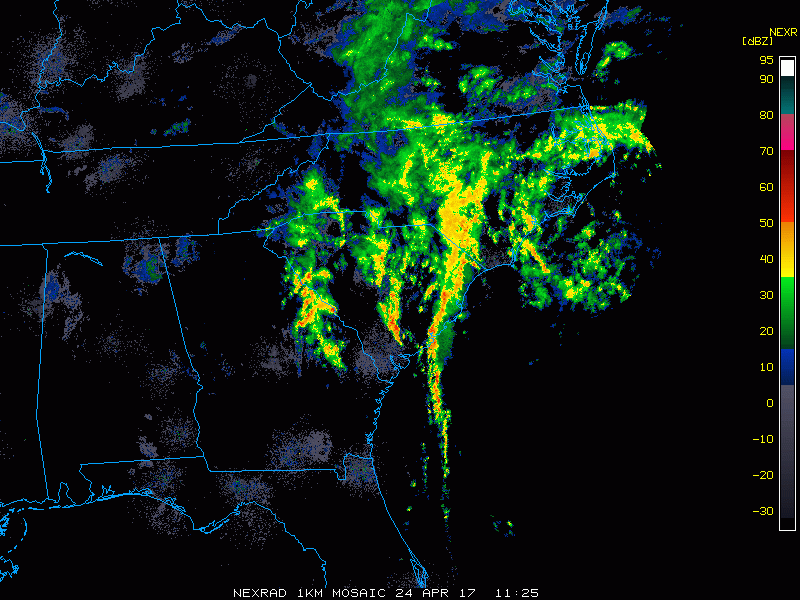
As of Monday morning, heavy rain was already coming down across a wide swath of the Southeast. One to three inches of rain has already fallen for parts of eastern Georgia, South Carolina, North Carolina and western Virginia, with the rain expected to continue through Monday afternoon and evening in these areas. The heavy rains have already led to some street flooding in parts of Charleston, South Carolina.
Heavy flooding @ Wentworth/Coming. Vehicle stalled- use caution #chswx #chstrfc #chs #flooding #drivesafely pic.twitter.com/ZGJnIvJPwo
— CofC Public Safety (@CofC_DPS) April 24, 2017
The narrow line showing up on the radar off the South Carolina coast will provide the focal point for some isolated severe thunderstorms for coastal areas of North and South Carolina Monday afternoon. Along with the heavy rain, the main threats will be damaging wind gusts, with an isolated tornado or two not out of the question.
Forecast Breakdown
The system currently moving through the Carolinas is a slow-mover and will be lingering over the Southeast Tuesday before slowly drifting north into the Mid-Atlantic Wednesday. An extra boost of moisture from the Atlantic Ocean will mean a two-day soaking for the region.
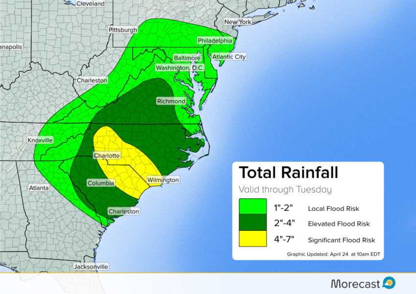
Models continue to depict a heavy rain “bullseye” over the South Carolina/North Carolina border, including the Charlotte area. The bulk of the rain for the Carolinas and western parts of Virginia will fall on Monday, with lingering but lighter showers for Tuesday.
Flooding potential will be high, especially on roads with poor drainage.
The heavier rains will shift into eastern Virginia Tuesday morning, continuing up through Delmarva, Delaware and into southern New Jersey and the Philadelphia area by Tuesday afternoon. The good news is that the system will pick up some speed, which will lead to lower rain totals compared to the Carolinas. That said, localized downpours will still be possible.
It’ll also be a dreary couple of days for the Appalachians and Mid-Atlantic, though these areas will escape the highest flooding risk. Keep an eye out for standing water on roads as isolated downpours will be likely.
As always, we’ll be keeping an eye on the situation. You can always access our latest updates via Twitter and Facebook, or using the scrolling ticker on your Morecast app.